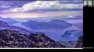
so it's today it's my pleasure to welcome dale lackey to our uh graduate seminar uh this is gonna be a great lecture so i'm gonna keep my introduction extremely short so they'll have lots of time for this talk and we will have lots of time for question and answer after the talk so for question and answer please type in the chat chat box we'll monitor the chat box and cure the answer the questions from there you are also feel you can also feel free to speak up yourself but we will give priority to the questions
that are typed in the chat box first after the presentation so dale uh has his bachelor and master in geography i believe from university of alberta is that correct though yeah the bachelor's is yes that's correct that makes up that makes us very proud and he's from in geology from mcmaster uh university he's a he was a practicing geologist and worked at both in the public and private sectors and he is also a junk adjunct professor at the university of calgary and right now he has just published a book called the scenic geology of alberta
or roadside touring and hiking diet i believe it's just published this april and i have not yet seen the book in our library yet but i believe it's coming so so just keep keep uh keep an eye out on that it's a it's a very good book i have uh i have one myself uh in my library so highly recommend it uh so without further delay i will give the podium to dale and welcome dale thank you very much tony thank you for to the group for organ or for inviting me and organizing this i
love it hey so what i want to talk to you about today is the scenic geology of alberta and i'm a geologist a professional geologist i have been all my career and i've always been teaching people i've been been scientific meetings taking people across the prairies into the mountains then i decided it was time to inform the public about how geology has made this phenomenally scenic landscape that we have in alberta and i've done that through two books and this is the second book so we'll step through alberta towards the end we're going to get
to a section that could interest this group when banks fail again from a high level touristic perspective so alberta just doesn't matter where you go in this province it's just so spectacular here's dry island buffalo jump and on the right hand side these are all landslides wherever you go along our river valleys um in alberta they're these large to small to giant landslides so how we're going to address the talk today is the scenic geology of alberta is a story about unbridled power it's a story about drama it's a story about glaciers long past and
it's a story about when banks fail so some of the scenery of alberta if you go west of edmonton to sulphur gates provincial recreation area near grand cache here's a water gap a treme an amazing amount of water and power of water is required to form this erode this ah southwest alberta pine ridge lookout rocky mountains rocky mountain foothills in the foreground and then the glaciated landscape southwest alberta game looking into the united states chief mountain police outpost provincial ephraim as viewed from police outpost provincial park just beautiful stunning scenery riding on stone provincial park
ice and ip national historic site in south central alberta right up on the border here in edmonton uh to willagar park there's oleski river valley park a meandering river point bar erosional um cut banks on this side in the foreground right in front of you and a flat flat flat glacial lake surface dinosaur provincial park scabland and badlands creates this unusual and beautiful topography milk river canyon southeast alberta um probably probably in my mind one of the prettier places we have in alberta might even rival the ice fields parkway between banff and jasper red rock
coulee south of medicine hat has been called a moonscape a little bit east to elk island national park and it's a glaciated terrain to give you these potholes um and that's what we cover in let's just bear with me here that's what we cover in the book that's it's it's places like that in the scenic in alberta that we cover in the scenic geology of alberta so i cover most of the province where those red dots are are places that i take people uh this photo of the giant dinosaur bone um was taken was taken
right there in edmonton just think of an animal that had bones like that in the book i also included art um acrylics um on canvas by the artist brent laycock and he put a bunch of his books into a bunch of his paintings into my book oh jesus sorry my mouse is messing up on me um also there's watercolors lucy kelly carry you lc carry you so put on your hiking boots fill your car with gas it's time to explore and learn how alberta's most scenic sites were created so we'll start the scenic geology of
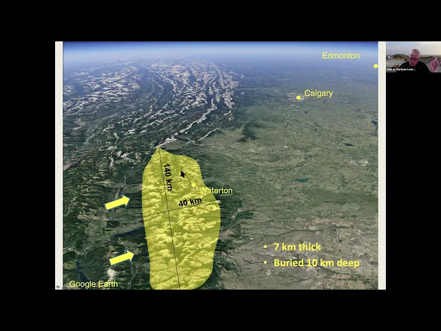
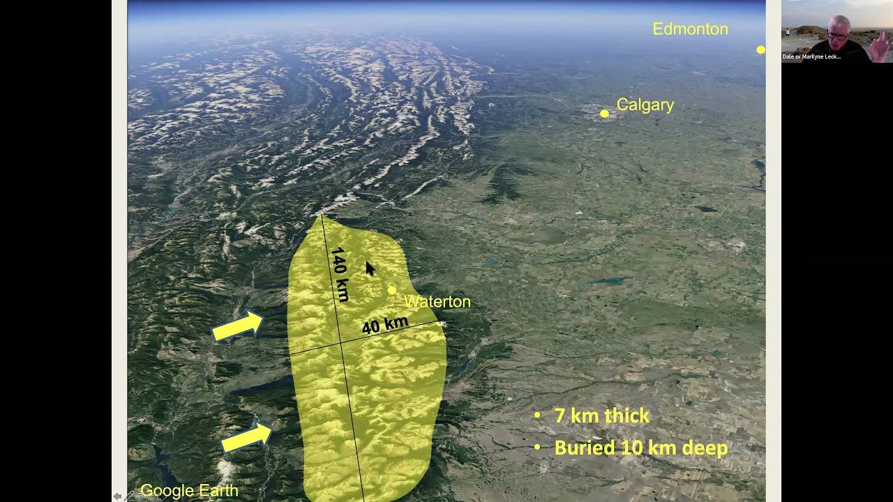
alberta is about unbridled power so we're going to start here in southwest alberta we're going to go to waterton lakes national park and this viewpoint which you see at this viewpoint you can see these mountains they've been thrust from 140 kilometers away and then they've been eroded there's been 10 kilometers of material eroded from the tops of these then you've got the rocky mountain foothills in the foreground that have been glaciated waterton the sediments at waterton are 1.5 billion that's with the b years old at the time southern alberta was south of the equator it
was a hot and harsh environment and there was much less oxygen in the atmosphere than we have today there was virtually no life on earth except for algae so i say that algae ruled the world at the time and these algae they lived in the sea there was nothing living on land at all it was just algae in the seas algae are slimy they've got a sticky surface so sand and silt and clay are deposited on the surface and the algae build up like this to form to to to to form um oh sorry to
form certain certain type of mass called as a stromatolite and that's what you see here um here's a larger stromatolite from waters and lakes but in on the internet on the right hand side is an example of a stromatolite or stromatolite field from east western australia there it's on the coast lots of evaporation uh the water evaporates the water that remains gets saltier and saltier and this becomes a very harsh environment there's no snails there's no gastropods living here that would normally eat the algae think of a fish tank how do you clean the algae
away from your fish tank you algae or sorry snails do it so here's a modern example of these 1.5 billion year old cabbage shape features so why am i showing you that well those stromatolites those algae create the cliffs that we see throughout waterton lakes national park 1.5 billion years old and boy so that sets the stage for waterton so now we're going to talk about the unbridled power here's a google earth image of waterton lakes national park area in through here and you can see that these mountains are markedly different than the mountains to
the north towards banff further north to jasper so let's take a look at those so that massive rocks originated 140 kilometers to the north to the southwest mountain building pushed this massive rocks from west to northeast when the rocks were deeply buried and these rocks are about seven kilometers thick so just think about that seven kilometers by 140 kilometers by 40 kilometers just think of the powers that are involved so those rocks came from the southwest 140 kilometers away they were pushed here and then from about 60 million years ago to now the mountains were
eroded to give you the shapes that you get so remember they were deeply buried they moved at millimeters to centimeters per year to get this position and then there was 10 kilometers of erosion this erosion is going to keep coming back as a common theme as the talk progresses and as a result you get this beautiful spectacular scenery at waterton lakes so remember those mountains 1.5 billion-year-old sediments they were buried probably 10 kilometers deep and then they've been eroded and uplifted that is power consider the forces that were involved to do that here's the google
earth image again let's take a look here at the waterton river valley and so we're going to go south of the valley and look north and i want you to imagine that thrust sheet that's how that thrush sheet was put in place and then remember there was 10 kilometers of material above this that was eroded and we get the landscape that we have today so go around the corner and there's the front of that thrust sheet rocky mountain foothills completely eroded away here a different type of foothills than you have in the jasper and the
banff area or east of those places more on bridal power let's go to edmonton you recognize this bridge it's the low-level bridge 1915 there was a flood and the flood went to the base of the lo of the level river bridge at that time the city was so worried that the bridge was going to be wiped out they had the canadian national railroad put a fully loaded train car box car on it to help it from not being eroded that's extremely impressive think of the power that's going there and we'll come back and visit the
north saskatchewan river a few times along this theme um think about unbridled power but this is the other extreme in edmonton at the park here's hudson's bay edmonton house the other extreme you had floods 1915 well in 1796 dodson's bay journals tell us that the rivers were so low that canoes couldn't were damaged the canoes couldn't be used to transport furs and supplies there being no water in the river beaver and buffalo populations were down um that year due to the dry weather and there were fires all around edmonton house on both sides of the
river so just the other extreme of that flood event had occurred about 120 years before the flood the scenic geology of alberta is about drama here we're going to go and we're going to go into the rocky mountain foothills south of calgary south of bragg creek and there's in the mountains a lot of these gravel ridges and these gravel ridges i believe are related to the legend of the lost lemon gold mine a story of murder and madness so and these this gravel um cemented gravel called a conglomerate it's called the mcdougall seeger conglomerate if
you go to the crow's nest pass um highway 3 and there's a great place you go to the parking lot and you can scramble up to the northeast right above the parking lot is this gravel this conglomerate there's a hike around the interpretive center and it takes you right in the middle of these gravels and there analyze the story of the lost lemon gold mine there were two trappers um mid to late 1800s black jack and lemon well blackjack was killed by lemon lemon became unstable he wandered out of the mountains he went into montana
to an area called the tobacco plains he told a story um to a priest and then after that the priest and other colorful people with or people with colorful names like lafayette french king bears paw john mcdougall and the blackfoot woman claude walker they all searched in vain for the gold sometimes they took lemon with them sometimes not they never found it found the gold they never found what they discovered there's said to be a curse discovered with those that explore for the gold mine tragic deaths fires storms serious illness so if you look at
the legend some of the names that are mentioned are dutch creek racehorse creek highwood river gold river old man river and up and down the rocky mountain foothills is where those rivers and streams occur well we've been able to identify a series of 100 million year old river channels which drained from west to east and that's where these gravels that you see in the pictures are from and in those gravels and the details don't really matter except they relate to the gold story there's volcanic pebbles there's igneous pebbles so volcanoes up above the igneous rocks
where'd they come from east central british columbia and associated where the igneous rocks are in outcrop are gold occurrences this was the site of the caribou gold rush in the 1800s so the story is the interpretation is these volcanoes these plutons were being eroded and the gold was being eroded and carried about 400 kilometers from the west to the east to be deposited in these ancient river deposits up and down the foothills is there gold there we've assated if you go to the base of a cliff and you grab some of the material that's weathered
out over time from the base put it in a bag take it down to the river and you can find anywhere from five to twenty colors in every pan they're not very big you're not going to retire but it's fun to explore for more drama the geology of alberta and drama the neutral hills destruct disruption in the prairies northeast to calgary southeast of edmonton are these ridges that really shouldn't be here you would think it looks like rocky mountain foothills if you look at a google earth image you can see these hills they extend for
70 kilometers from west to east they're 120 meters high one of alberta's early explorers in the 1700s he noticed them john captain john paliser and put them onto his maps and in his report so why are they there glaciers from the north glaciers pushed and thrust bedrock to create these ice thrust reaches ridges the ice would advance and then it would recede it would melt back when it melted back there was other block abandoned blocks of ice were left there and that was reincorporated into next time the ice moved forward and when the ice melted
out it left these lakes that we see here there are the ridges there are the ridges there there are these old ice blocks that melted out and if you're ever exploring this part of alberta gooseberry lake provincial park is a beautiful park why do i call this drama well the neutral hills where did the name come from it was a territory to be shared by the crow and the blackfoot people first nations people um the area was great for buffalo there were berries there winter protection from wind lots of firewood poplar trees um however the
crow and the black foot were constantly skirmishing fighting the great spira was upset by that one day one night it was said that he put his finger down on the earth and lifted up those ridges the two tribes woke up in the morning and there was a ridge separating them they walked on either side of the ridges to this gap between the ridges they met and then they made peace and therein lies the name the neutral hills that's an unattributed story on the origin of the neutral hills let's go back into southwest alberta wally's beach
a hike within a lake place to seen landscape so northeast of waterson lakes national park if you know alberta southwest of mcgrath st mary's river um has they damned it and it's created a reservoir so way in the distance here is the reservoir during the summer the water is high as the bottom of the slide and it's a beautiful little beach and it's another beautiful little park you can see the reservoir you walk out there a kilometer or two and what you can find are mammoth tracks that's what these are woolly mammoths they're up to
50 centimeters across they found the archaeologists up to 500 of them there are camel tracks there are now antique horse footprints there's musk tracks there so the interesting part about this besides the tracks and the bones is the the archaeologists have also found butchered horses butchered camels they found stone tools with proteins on them and those have been dated at 13 300 years ago so early north americans were hunting these large fauna at the time here's some of the bones some of the tools that would have been being used it was bleak at the time
it was a very bleak landscape the ice had just from the large laurentide ice sheet had just melted back and this area was ice-free but there were valley glaciers here it would have been harsh and cold windy all the time glaciers like i say here in the distance very few trees it was step like low vegetation and shrubs here's lucy carrier's rendition of that her painting and i think she's captured the bleakness of it very nicely more drama dinosaurs perish meteor impacts and never-ending floods let's go to the red deer river valley dry island buffalo
jump for this and dry island buffalo john jump you'll go to one of these knolls that's like this down towards the river and the paleontologists have found bone beds in this instance of albertasaurus a mediating dinosaur that eventually evolved into tyrannosaurs they found 26 specimens um in the bone beds there they ranged in age from two to 24 years and old and they they from that the paleontologists suggest well perhaps this giant carnivore hunted in packs which is really a scary situation so why do we have these concentrations these bone beds of these fossils well
if you go to africa today and here's kenya this is wildebeest trying to cross a river wildebeest they're herbivores they're not carnivores like albertasaurus but it shows you kind of how these concentrations would have occurred they will try to cross the river they will drop they will quite they will drown and you can see the carcasses of the wildebeest here you can see the animals that are care that are eating the carrion um and that is what would have happened with the albertosaurus keros um carcasses and then the next flood comes along picks up all
the bones and carries it downstream to be deposited to be deposited in a point bar and that's how the alberta saurus bones would be concentrated more drama 66.5 million years ago on meteorite hit the earth 20 kilometers across it created a crater in the yucatan peninsula 200 kilometers across and if you go um up and down the red jay river valley you can see that instant in time where the dash yellow line is when the meteor hit the earth if you go downstream a few kilometers there it is right there where that color change occurs
in the photo in the lower right and geologists have recovered iridium which originates from space as well as shocked quartz from this interval right here now a meteor hitting the earth is probably the most cataclysmic thing that can occur when this one hit there were giant fires just instantly darkness prevailed from the ejected debris and soot from those fires there was nitric acid rain and then sulfuric acid aerosols um from the impact cooled the air the earth it was nuclear winter and then that was followed by extreme co2 levels causing intense global warming when the
meteorite hit 76 percent of all species died it was a cataclysm let's look at glaciers the scenic geology of alberta is about glaciers long past here's ice thickness map of alberta and across alberta the ice was up to four kilometers thick 3.8 in 3.8 kilometers up in the north thinning southward in edmonton about three kilometers of ice covered the city if you run a cross section from north to south you can see the ice being thick in the north thinning southwards to the alberta montana border you can see the topography the landscape rises from north
to south the ice actually flows uphill because of the profile shape on top which is kind of interesting so the ice started to was at its maximum we'll say 22 000 years ago all of alberta was covered except for these areas here which are called nude attacks they would have just been sticking up above the ice and the ice started to melt about 15 to 17 000 years ago 14 000 years ago there was an ice free corridor here and edmonton is just about to be deglaciated remember this we'll come back here 12 13 000
years ago by 10 300 300 years ago the ice was gone so what did that ice do well south of calgary and along the rocky mountain foothills south of hinton to the montana border are these giant glacial erratics what happened why are they there so this is the ocotoceratic south of calgary city of okotoks just a little bit west of okotoks is where this giant block is and it is truly block a giant so what happened in jasper on mount edith cavell there was a landslide a landslide um took place and deposited probably hundreds of
millions of tons of debris onto a valley glacier that valley glacier flowed north out to the foothills bumped into the lauren tied ice sheet which was up to three kilometers thick therefore the valley glaciers were deflected south and debris was transported all the way south to montana and that's what gives us those giant blocks there's mount edith cavell and those blocks are a distinctive type of quartzite that's about half a billion years old and and we know that it came from maunita cavall based on the based on the rock type and and tracking them back
up into the valley does that occur today yes it does here's an example of the alaska range in alaska big landslide probably because of earthquakes onto the glacier another one here and then that debris is carried out just like it is here in this example i'm showing here glaciers long past let's look at edmonton here's a google earth image of edmonton it's dissected it's dissected by the north saskatchewan river well edmonton is built on a glacial lake bottom it is such a flat flat flat landscape that's because it's this old glacial lake with up to
about 15 meters of silt because of this silt it's great for building tunnels and the rapid transit system in edmonton i think that's so impressive compared to our other cities and then the city the river the city the area is dissected by the north saskatchewan river meandering and deep um so why is the has the river so deeply in size well remember there was about three kilometers of ice here the ice melted that's a tremendous weight on the prairie landscape the landscape lifted up and as the landscape lifted up the river down cut that's much
like the erosion that takes place in the rockies when i told you that waterton was there was 10 kilometers of erosion it doesn't mean that waterton was 10 kilometers sorry the mountains at waterton were 10 kilometers higher no when the erosion takes place isostatic rebound lifts lets the mountains lift up just like a melting iceberg off the east coast of canada as the top of the iceberg melts the land the iceberg rises up the same thing with our prairie landscape here when the ice was starting to melt back there was ice on three sides of
the city at least and it was just pouring water into here glacial lake edmonton formed and then the lake started to drain initially south of the city gwyn channel towards the airport and then that became abandoned and the city started to drain northwards taking its present position oh sorry the lake the drained northwards creating the valley where we get the north saskatchewan river valley now go to twilight park and you can see this flat flat landscape that's your flat landscape here's the entrenched river valley from the glacial uplift before the edmonton river valley had been
cut there were older river valleys here's an old river course at least 60 to 25 000 years ago the north saskatchewan river occupies that river course in part for part of its course but a lot of these gravels provide the the aggregate of sand and gravel that's mined taken out of the ground in the edmonton area so this is a pre-glacial river valley that flowed in edmonton again you go to twilight park go to the end of the little point bar and look across the river and you can see bedrock you can see the sands
and gravels from that old river system pre-glacial river system and then there's the glacial deposits there at the time and after the ice melted there were these large panthers that were migrating not migrating that were hunting in the edmonton area edmonton was covered by three kilometers of ice deglaciation and uplift took place in the last 21 21 000 years um and the ice probably left edmonton by about 14 000 years ago let's go a little bit we'll come um we'll come back there in a little bit let's go to elk island national park um east
of edmonton and it's got these low-lying hills shallow wetlands shallow lakes lots of wetlands during the last glaciation ice would stream a little bit faster on either side of the area where elk island national park is this was a subtle little highland so there's elk island national park eastern east of elk island the ice would stream and in the sherwood park area and if you run a cross section from southwest to northeast across that area you can see elk island national park is built on a subtle little high and then when the ice was melting
a giant block became isolated and stagnated right there and after that ice left we had this terrain the cooking lake moraine this glacial moraine all through here which is markedly different from the landscape to the east and to the west geologists have all sorts of different names prairie mounds rimmed ridges ice wall lake plains prairie donuts the names don't matter but they're descriptive and it's great waterfowl terrain and beavers love it briefly let's go to cole lake northeast of edmonton 93 99 meters deep it was covered by three kilometers of ice during the last glaciation
the ice actually pushed and excavated debris once when it was flowing in this direction and another time in this direction to create that extremely deep lake the next photo is from 30 kilometers south a lake called muriel lake and you can see the debris that's been pushed from cold lake 35 kilometers to form this landscape this hill here and muriel lake in itself is another ice thrust lake characterized you can tell them they've got long straight shorelines very very very very steep banks there's a few other criteria but those jump out at you so let's
deal with when banks fail we're going to go to edmonton again north saskatchewan river valley we talked about how d how it floods we talked about how it dries up we talked talked about how deeply incised it is well it's the incision which is important for this part of the story the north saskatchewan river is a meandering river so it erodes on one side shown here where i've labeled erosion and it deposits here these point bars sand and gravel point bars historically they were gravel pits then they were made into municipal parks they've been made
into golf courses and again parks that we see in through here so the story here is you get erosion on one side you get erosion here you get erosion here deposition here so what happens is the river the north saskatchewan river flowing in the easterly direction undercuts the this deep steep banks there's volcanic ash in the bedrock volcanic ash is extremely slippery basically everything will slip on it so easily when it gets wet um there's groundwater seepage has weakened the hill slopes as well as the undercutting residential development so homes people watering their lawns water
in percolates down there's old coal mines there's more than 100 coal mines along the red edmonton river valley and that's allowed access for water as well as to weaken the bedrock so an example of that well here's some bentonite it's not a very thick one but thicker ones like this would be that could be and are attributed to be the slip surface for some of those landslides the one that i like and talk about but there's several of them in the city is keeler point here is keeler road this used to be a road which
went right through here we've got bedrock and glacial thrust bedrock river erosion because of the undercutting there was a down drop block here 1989. there's another down drop block that took place here in 2002 the city tried to remediate prevent the damage so they put in these great pylons well it didn't do the job keeler road is gone there's the pylons there's old keeler road and you know sometimes you just can't figure out microsoft um you can walk down there's in belgravia nice little park and this is built on those pylons and you can see
a lot the slump you can see the slides you can see the point bar across the river go a little bit further east let's go to downtown edmonton so there's downtown edmonton louise mckinney waterfront park why would the city make such a large park um in in such an inexpensive potentially expensive area well that's all landslide in through here nineteen hundreds um nineteen hundred more or less cracks started to develop at the top of the red deer at the edmond north saskatchewan river valley and then 1910 there was major displacement dawn drop block and all
all these slump blocks in through here the city back filled this hole they backfilled with the green material in through here today um and then they put erosion prevention material in the park there so basically that part of the city is at high risk to landslides the city built this beautiful park because if damage occurs here there's not it's not going to be extensive this is to be a movement tolerant building here's the extensive riprap in through here let's leave edmonton and go north ver just show you a picture here's the peace river i worked
extensively along the peace river valley throughout my career and it seemed wherever you went along that river valley wherever the cretaceous marine shales were we always had slumps this is at the town of peace river on the peace river the smoky river is here and wherever i label this is a slump it's a landslide it's just absolutely amazing i i always described this river valley as being in motion on its erosional side and there's just a cartoon from the alberta geological survey showing some of the slumps and they take place either in the cretaceous marine
shales or glacial equestrian deposits um that are within the river valley crow's nest pass not really bank failure but still fits the theme april 29 1903 canada's largest landslide it took place it blocked the railroad it blocked the highway half the town of frank was destroyed and at least 90 people were killed the reason it took place was folding off of devonian and mississippi and bedrock so if you fold rocks bend them in half they weaken basically tension occurs on top weaken those rocks and then there was thrusting where those red lines are there is
potential that coal mining at the base of the mountains contributed to the turtle mountain search or the frank slide on turtle mountain and this area has been glaciated many times in the last two and a half million years which would have over steepened the mountain as a result you get the frank slide um did you know that mountain building in the rocky mountains has come to an end those majestic mountains that we know and love uh they're wearing away um why are they wearing away what's happening um there's been multi multiple glaciations in the last
two and a half million years rock falls tailless slopes landslides debris flows at least 20 kilometers of material have been eroded from the tops of the mountains in yoho national park in banff in jasper it's about seven kilometers let's go to yoho here's cathedral craigs remember 20 kilometers of erosion here from rock falls tailless debris flows glaciation and what happens is we get this debris eroding coming down into the river valley at the base of the slide and we get isostatic rebound we get uplift it's just unstable precipitous cliffs there into the river and into
the pacific ocean so the erosion of these mountains creates natural hazards so let's take a look at the debris flows in the kicking horse pass so two debris flows coming off cathedral mountain cathedral crags as well as the one coming off mount steven next photo we're going to deal with the one coming off cathedral crags and what you can see there's cathedral crags right at the top of the slide is a glacier you can see a gulch where the debris flow debris comes down comes plummeting down crosses the railroad at the spiral tunnels crosses the
railroad here as well sometimes if it's a big debris flow it crosses the highway what happens at the top well there's the glacier and you can see the vertical cliffs you can see the loose debris you can see how unstable it is up there so the story the interpretation here put together is that during summers snowmelt glacial melt there's lakes that build up on that ice on that glacier eventually there's so much water builds up that the ice lifts off and the water escapes and you get a large volume of water taking that debris downslope
it takes it down the mountain side of cathedral mountain crosses the tracks a couple times the train track of the transcanada maybe and maybe even the third tracks let's take a look at another debris flow there let's look at the one coming off mount stephen so here's mount steven and the interesting thing here you can see a debris flow chute coming off the mountain you can see canadian pacific railway gray at grain cars and the trans-canada highway go to there's a viewpoint where you can see this and you can see cathedral craigs you can see
stout you can see mount stephen you can see the debris flow how the engineers have trained it with these artificial levees to keep it in past here and then the railroad has built this tunnel for further protection which is good sometimes it'll make it to the transcanada highway sometimes it will not so the scenic geology of alberta is a story about unbridled power it's a story of drama it's a story of glaciers long past and it's a story of when banks fail and that all contributes to see that spectacular scenery that we've got across the
province i'd like to acknowledge the canadian geological foundation and the alberta government i received a grant from both of those um organizations government to prevent the book or to publish the book if you're interested in the book it is you can buy it locally it's in audrey's books downtown jasper avenue it's in the bookstore in perron in saint albert and chapters indigo's covers it so thank you very much for your time hey thank you death the presentations very interesting and we have a a good flow of questions coming in um so the first question is
uh based on the variation in the cover thickness of the laurentine ice sheet over 10 or 20 000 years ago well this explains why the clay or fines or even the organic content in the glacial tl deposit increase the more north and the more east you had in alberta i want to take a look at uh chat i got to make sure sorry i'm just reading that chat yeah i don't have for sure the answer to that but i'm gonna as you go in the northern half of alberta we are covered by um a lot
the cretaceous bedrock is mostly marine shale i showed you a bit of that marine shale when i took you to peace river so that marine shale is easily eroded and that's what in that would contribute to the clay content in the till and as you go further south the clays are still there that it's still marine trails but we start to pick up more sands um and other types of deposits so again not my field in detail but i believe you know basically the content of glacial till reflects the material upstream and just upstream and
and that's why um there is that higher clay content so thank you dale um i guess the follow-up question would be on the iso static rebound especially for areas where you have multiple glacial advance and re-advanced retreat uh are we gonna see the isostatic rebound in those regions uh less prominent than the areas where there's only um maybe a single episode of uh a glacial retreat you know that's kind of interesting because edmonton might have been affected by two glaciations over time um calgary was only affected by one major ice age there was glaciers in
the east of edmonton as well as the laurentide ice sheet you know from the mountains and i'm talking over the last two and a half million years we don't have good evidence that there was two in edmonton so basically if you go to cole lake there is evidence for two icy glaciations but okay so the early glaciations would have caught and i don't know if i'm answering the question properly the early glaciations would have caused the subsidence it would have started to rebound again and then a subsequent glaciation would have caused the subsidence again and
it would have been cumulative alberta is still being uplifted from the last ice age and remember the glaciers left alberta 10 000 years ago there are parts um parts of alberta are still uplifting and in the southern part because it's on the amount of uplift is is is varies there's actually substance going on uh so we've got uplift we've got subsidence it's an extremely complicated stories which the geophysicists work to uh understand and help us with and i got those thickness maps based on work coming out of the university of toronto where this is the
indi the scientists were trying to understand the amount of isostatic rebound that took place good great question yes uh i guess my my follow-up to that is a question is that uh you it's very difficult to fact to find any outcrops or were even from the bro holes to to kind of understand this rebound with a little bit more extensive studies i guess it is so difficult to do um because you can understand you can stand study um glacial rebound isoscele in the arctic by finding ridges and beet ridges and dating them with bones and
stuff but in the prairies in southern canada we cannot do that and so it's up to the modelers largely the geophysical modelers uh we have more questions uh so this question from kevin so he went to uh waterton lake national park uh this year and he was surprised by how quickly the mountains just sort of pop out of the ground so could you touch a little bit more on their formation being pushed in from the west toward the northeast is this due to a tectonic plate from the north pacific ocean i got to think about
how to answer that so just just let me think just just give me a meant a thought yeah they do sort of pop out and it's just like when you go west to calgary um and you see mount yam naska and it's like when you go west of edmonton into jasper they just kind of pop up but you but that's where where that's occurring and i'll say where those pop-ups are that is where the older bedrock in the case of waterton it's the 1.5 billion year old resistant erosional resistant ridges remember there's been 10 kilometers
been taken off the top of that in front of those ridges at waterton it's cretaceous shales marine shales which are very easily eroded and that is why it seems that i really like what you just said looks like they popped up but actually they would have been almost the same but because of the differential erosion of the marine shales that it looks that way so it's largely related to erosion i hope that answers your question kevin can i feel free to speak up if you want to follow up no i think that was that was
great i think that his other right to hit the nail on the head there thanks still okay uh so next question uh it's about the those glacial lakes formerly edmonton um cherry asked i wonder why those lakes from the edmonton did not dry out three evaporation after the ice sheets receded i think that's the question and it's going to be two words and it's not the ones you're thinking of it's too cold you know basically the ice is melting back um you could see if you remember that map i showed you ice all around all
around the lake and and it's so cold there those of you who have been to um the columbia ice fields and walked out taken taken the hike you can feel the cold catabatic winds blowing off the glaciers and and the blowing winds would have contributed to some to evaporation but it was just too cold to have high rates of evaporation and so one of our story for alberta is that is that a lot we all across alberta when the ice was melting back glaciers formed up against sorry lakes formed up against the glaciers and those
lakes catastrophically drained to cut deep valleys you know if you're driving across the prairie and you come across a big deep valley and there's no river in the bottom of it it was probably cut by a glacial melt water channel from when these lakes catastrophically drained so too cold i would say for the evaporation you're suggesting great question dale when you say uh catastrophically drained are you talking about a one day event that sort of event uh just the the the dam bridge and uh outburst and or is it difficult to tell days to weeks
probably days two weeks yep you know you would start and then just sort of you would build up intensity the lake would be filled with all sorts of giant coarse ice crystals you know material calving off off the glacier floating in the water and then that would all contribute to erosion so i'm going to say days to a few weeks that's very fastly geologically speaking i think it's instantaneous yes okay i i uh i asked this question during your talk in uh at the edmonton public library but i i just want to ask again so
everyone can hear it uh for the uh you know the cretaceous uh uh the kt boundary where the um where that extinction event happened possibly through a meteorite uh all that don't say possibly possible okay so my question is uh uh can you suggest any uh outcrops we can easily hike to or visit to actually perhaps touch that with with our hand or just instead of going to the drum helder museum and and see that from there where because i saw a photo of uh of that kt boundary in your presentation slide with the yeah
so the scale and is there it's so difficult to go put your finger on it the two pictures i showed in my talk you can see it and you know it's at the base of the coal but it's very difficult to climb up there at least you know depends it is it's hiking in badlands terrain or topography can be pretty difficult that's a steep cliff the other one was on private property it was a farmer's field and so we had to get permission to go on there and to go see it and so did the
geologists that had done the research there is one place that i remember seeing about 20 years ago along the old man river valley and i've never never been able to find it again and it's where the old man river reservoir is uh and i and a friend of us friend of ours took us there on a field trip those are about the only places i know there most of them tony are inaccessible in the province the best one is to go to that one at dry island buffalo jump hike in and find that spot i
show in the book and say there it is there if you're feeling brave you might be able to yeah i say it tongue-in-cheek um you might be able to find a way to get up and you right at the base of the coal you look for that and if you and dig away with a shovel no you're in a park don't dig right you get in trouble but look for that color change and that's it so it's very uh it's not that easy it's not something that you can identify with the binocular uh maybe not
no okay so you have to either peel away or look really really close yeah okay i i love your interest in asking that question because it is so important to our history that's right because i i saw every time i i've been to drumheller museum couple times and i always see that kt boundary uh display yeah it does seem very obvious from the display but i always wonder where i can find that uh sort of institute in the field it's it's really difficult it's really right and i'm not trying to hide it if i could
find you a spot where you could go i would tell you where you could update the book yeah yeah well i i if it was there i'd yeah awesome thank you okay i i don't see any other question in the chat box uh i think that's that's a wrap and this is a great talk again thank you very so much for the presentation thank you very much to the group thank you and uh this is our last graduate seminar uh for the semester so um we'll start again uh next year so thank you everyone for
uh attending those seminars and we appreciate your uh your support thank you dale thank you guys for joining us during the semester and see you guys next year uh have a joyful holidays see you guys bye bye take care bye bye bye