another record shattering weather pattern will be coming to the United States over the next few days and this is going to bring record-breaking high temperatures across a large chunk of the United States all the way from the southwest and the Southern Plains back into the Midwest in the Ohio Valley in addition to this we are watching for the potential of several different large storms as we go into the end of October and into early in mid November and those could actually bring some severe weather and as well as some Colder Weather and lastly we're going
to update you on the ICS as we now have a new area of development in the Caribbean Sea which may end up impacting land as we go into November so let's begin with what's happening across the United States this morning which for the time being things are looking relatively nice not really much happening across the lower 48 it's been a pretty quiet weekend for the most part The Only Exception being back up in the Pacific Northwest which is actually where we have an atmospheric River Event occurring which is basically a big plume of moisture that
is continuing to dump several inches of rainfall across areas like Washington Oregon and as well as Northern California for the time being things look relatively quiet in the tropics but we are again looking at an area of development just down to the south of Cuba that could actually become our next tropical storm or hurricane as we go into early November and there is a low chance it could even impact the United States so we'll be talking more about that here in just a few minutes now one of the biggest changes that is going to be
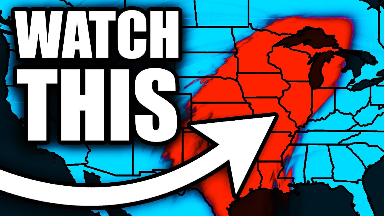
happening over the next few days is going to be related to the jet stream and our overall weather pattern what we're dealing with right now is a large ridge and this is really just dominating across much of the Great Plains in the Eastern here of the United States what this essentially is is it's basically a wall that is preventing any sort of large scale troughs from bringing tons of cold air into the United States you'll notice where the jet stream is right now it is lifted all the way back up to the north this is
not very typical by the way for this time of the year the jet stream is usually further down to the South which usually leads to more snowall events and also Colder Weather but we're not really seeing that right now because all that heat is just building up here AC Ross the Southern Tier of the United States and that's going up into areas like the Midwest in the Ohio Valley however we do have some troughing back over in the Pacific Northwest and a lot of that is coming from this atmospheric River Event we're actually going to
see this trough move across the Rocky Mountains as we go into Tuesday into Wednesday and though this is not expected to be a big severe weather maker it is actually expected to bring some very beneficial rainfall across the Midwest the Southern and Central Plains and back through the Ohio Valley and for those that live in those areas there is a major drought happening across a very large chunk of the Great Plains in the midwest so this is definitely going to be something that is very beneficial as we go into the middle of the week and
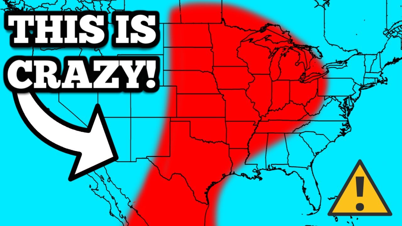
luckily the severe weather probabilities do remain low at least for now as we go into Thursday and Friday that trough moves out but look at this as we go into next weekend we are likely going to get another big dip in the jet stream and this is going to do one of two things one of which it'll bring up potential for more severe weather this one will probably be a higher chance I would say if this does eject over the Rocky Mountains the second thing thing is that it will likely bring colder weather as well
to a large chunk of the Great Plains so you'll see this as we go into the following week around November 5th and 6th that trough will move across parts of the Great Plains the Midwest and eventually it's out of here sometime as we go into the second week of November now here's what it looks like on the future radar over the next few days so again look at the Pacific Northwest dealing with several inches of rain and even some snow in the higher elevations through the rest of this weekend as and then as we go
into early this week we're going to be dealing with that one F trough that's going to move over the Rocky Mountains around Tuesday night this is actually going to bring two things one of which will be rain across much of the Midwest and the Great Plains you'll see that in a moment it's also going to bring our first snowfall of the Season across parts of the Northern Plains and also the Rocky Mountains so our first snowfall is coming right around the corner it's not looking like a full-blown blizzard but there will at least be a
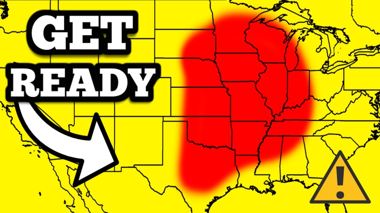
few inches of r or snow excuse me across North Dakota South Dakota and then back through areas like Colorado this is by Wednesday morning look at this TR start to actually intensify just a little bit when it comes to moisture we are eventually going to see showers and thunderstorms on Wednesday from the Midwest back through the Southern Plains there is a low-end risk for severe weather on Wednesday and I do think our greatest chance for that will be in the Central and Southern Plains if things look concerning we'll be live here on the channel so
make sure you're subscribe down below for the time being though it does look like a Rel relatively low chance for Wednesday as we go into Thursday that rain will start to move to the east into the Ohio Valley which desperately needs rain especially for Ohio and West Virginia and it'll also move back down into the Dixie Alley and those areas don't really need as much rain as the Ohio Valley as we go into Saturday into Sunday again we're going to start to see a really impressive weather pattern take place where a strong southerly pole will
come out of the golf of Mexico leading to plenty of moisture across the Great Plains in the midwest this should bring additional inches of rainfall as we go into the weekend and early into the following week before we probably get something a bit more organized and again whatever becomes more organized as we into the uh first full week of November we'll have a better chance of producing the threat of severe weather at least for right now things remain pretty uncertain I kind of went ahead a little bit too far but I'm going to just point
this out yes the GFS model is showing a major hurricane east of Florida on November 7th I'm just going to point this out right now there is no signs in forecasting something that far out especially in the tropics but we are going to be talking about that possibility here in just a few minutes here's what the rainfall accumulation looks like over the next several days this is all the way through Friday of this week again anywhere in the green purple or even some of those red areas is anywhere from about a tenth of an inch
of rain which is that green color all the way up closer to 1 to two inches of rain in the Blues and purples and even back down in the Reds that is where you could see anywhere from 3 to 6 Ines of rain so very beneficial rainfall here across a large chunk of the United States and also look back up here in the Pacific Northwest Washington and Oregon getting anywhere from 3 to 6 Ines of rain over the next few days and then as we go into the following week again more and more rain is
going to be falling for those that that need it in the midwest in the Ohio Valley and overall you know October has been a very dry month for most of the United States so we will definitely take any rain that we can get and this is the drought monitor that has just come out and this is going to give you an idea of where the drought exists and it really exists across almost the entire country over 50% of the United States has some level of drought and look at the Midwest every area at least in
an abnormally dry patch if not in a moderate to even severe drought even back over in the Central and Southern PLS several areas now in an extreme drought we also have some areas in an exceptional drought which is the highest tier that you can get that's in Ohio West Virginia back up in Montana Wyoming and also back down over in uh West Texas so this is a very serious situation we need rain and the drought just continues to get worse as we continue to have a high pressure system dominating but again as we go into
November I think things are going to start to change at least a little bit now I know many of you are hoping for snow as we go into November and at least for the first week we're not really looking at much the only areas that are going to see much of any snow in the first week of November or even in the end here of October will be mostly in the Northern Plains in the Rocky Mountains a few areas there will pick up anywhere from 1 to 5 Ines of snow again nothing really too crazy
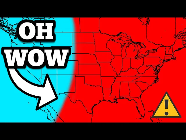
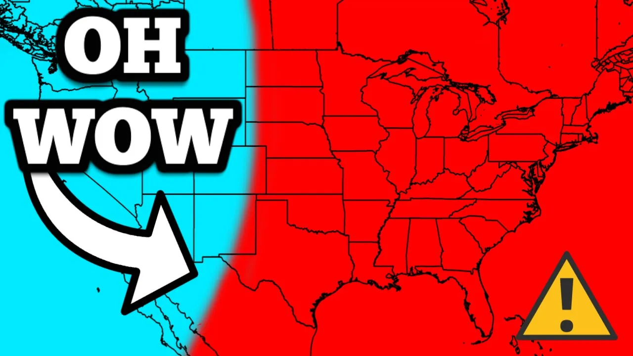
there in terms of precipitation though over the next 6 to 10 days above average rainfall expected for a large chunk of the United States as we go into the first week of November so very good news there now the temperatures over the next several days they are going to be shattering records across much of the country a very large area of a warm air mass is going to dominate the Midwest the Great Plains and even back through the Ohio Valley many areas will'll be dealing with record-breaking high temperatures through the early and mid portions of
this week then eventually by the end of the week we're going to go back to round average or just below average temperatures in many areas and then by the weekend things are going to warm right back up again so it is very warm across much of the country for this time of the year this is a little map to show you where record-breaking high temperatures are forecasted for the next few days this is today so notice again many areas in the southwest and also in the Southern Plains in some ballpark of seeing record-breaking high temperatures
tomorrow is where we're going to see the most widespread record-breaking high temperatures especially across the Central and Southern Plains even Minneapolis expected to be 72 degrees tomorrow and again we're in the end of October right now as we go into Tuesday this is going to spread across the Midwest and the Southern Plains Wednesday it's going to be anywhere from the Northeast back into parts of Texas and even Thursday back up in the Northeast almost everywhere up there we'll be dealing with record-breaking high temperatures again this is just shocking for this time of the year might
be wondering are we going to see any record-breaking low temperatures well not really none are forecasted really this week the only thing that's currently forecasted is a record-breaking low maximum temperature back over in San Francisco just a quick update on the tropics we do now have a new area of development in the Caribbean Sea this does have a 20% chance of development over the next 7 Days however it is likely to become our next tropical Cyclone some time as we go into early November now let's talk a little bit more about where this could go
and how intense it could get it's very hard to predict a system like this since it hasn't even developed a core or a low pressure center yet as we go though into later this week around Friday or Saturday that's when we're starting to expect at least some sort of low pressure center to form in the Southern Caribbean Sea and then from there we're not really sure where this will go but about half of the Ensemble members bring this to a hurricane status sometime by early next week so around Monday or Tuesday that's November fourth or
fifth but about half of them still not really showing much of any intensification here's where things get a little bit confusing if something actually develops it actually could go towards Florida I'm not saying that's going to happen but a couple of these Ensemble members bring this close to Florida or even into Florida but here's the other thing the timing is going to be pretty critical because these Ensemble members here around November 5th and 6th really stall here in the greater in Tilly region and also in the northern Caribbean SE for a few days if that
happens that will throw a big curveball into everything so this is going to be something have to watch for closely it's hard to forecast though what's going to happen S Plus days out since nothing has even formed yet but if something does become a bit more concerning here especially for something like Florida we'll definitely keep you posted with the latest so again make sure you are subscribed to the channel just heads up there are only 4 days left to get 500,000 subscriber merch we still have our hats available t-shirts our beanies mugs and stickers they
are all available at shopmax velocity.net that is the top Link in the description below and also the 200 500,000 subscriber hats that we sold that are signed are all sold out and they've all now shipped out for the most part there are still a few that have not shipped out yet but you should get a tracking number by today in your email if you picked up one it was a crazy operation it took over eight hours to sign all these hats but it was a lot of fun and hopefully you guys enjoy your sign hat
if you got one thank you all so much for watching make sure hit the like button down below and subscribe if you've not already