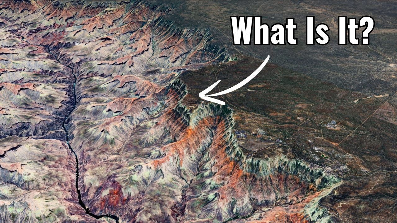
Nature's beauty is breathtaking with its towering mountains picturesque Landscapes and vibrant colored Rivers unfortunately many of us can't explore these wonders in person however thanks to the advancements in drone technology and highdefinition cameras we can now witness hidden marvels of the world that were once thought to be in accessible or non-existent join us on a journey to uncover 20 remarkable discoveries from the enigmatic blue eye of Africa to when a drone makes a chilling Discovery in a canyon that no one is supposed to see number 20 the giant blue eye of Africa the ree structure
sometimes referred to as the bluee eye of Africa or the eye of the Sahara is an intriguing geological feature that when viewed from above particularly with the aid of drone technology resembles a massive eye this amazing Landmark is visible from space because it is so large and distinct Drone footage of the peaceful Heights reveals the rot structure a cosmic work of art carved out of the baron Sahara Desert it is a fascinating and mysterious site with its almost perfect round structure and concentric Rings radiating outward from a central point Drone footage reveals the symmetrical patterns
that span the terrain highlighting the minute features of this enormous creation because of its round form some people initially believed it was formed by a meteorite impact While others believed it might be a volcanic formation nevertheless the volcanic explanation has been proven false due to the lack of volcanic materials in the formation nowadays the most widely accepted theory states that the rot structure was created by the gradual erosion of a prehistoric Granite Dome the regularity of the rishaw structures concentric Rings each precisely separated from the central Peak adds to its Allure the structure's attraction and
the scientific curiosity it arouses are enhanced by this exact geometric Arrangement which is challenged in to understand geologically speaking the rat structure offers a singular window into Earth's past the worn rock strata provide important information about the millions of years of sedimentation uplift and erosion processes that have produced this unique feature number 19 humanlike town without the help of a drone few would have realized the unique shape of century a town on the Italian island of Sicily when viewed from above centuripe astonishingly resembles the silhouette of of a person who might have had a bit
too much to drink a quirky yet beautiful perspective this new way of seeing familiar places is one of the wonders of aerial photography and photographer po Andrea Perry captured this in a truly remarkable way Perry a native of centuripe used his drone to photograph his hometown revealing a surprising feature that brought widespread attention to the small village while centuripe was already known for its Rich collection of Roman ruins and rare ancient sculp sculptures Perry highlighted its distinctive geography after spotting its unusual shape on Google Earth he decided to take his drone to the skies and
explore further what he discovered was that centur Up's five distinct points radiate out from a central Hub forming a shape that unmistakably resembles a human figure due to the limitations of his drone Perry had to stitch together multiple images to capture the entire Village when he shared these images online they quickly went viral earning centuripe the name the town that looks like a human and for those skeptical of Perry's work a quick glance at Google Earth confirms that this image was not altered the ancient town perched on a hill for strategic reasons dates back to
the 16th century and is home to about 5,000 residents today its tiny winding streets and terraced buildings add to its charm but the real mystery lies in its design was this humanlike shape the result of natural forces or did some Visionary Minds Planet centuries ago one thing is certain Mother Nature is always full of surprises number 18 the big face imagine soaring as high as a drone and suddenly spotting a large face carved into The Greenery of hail's Quarry Park in Edinburgh this mysterious image is said to be a tribute to a solitary man who
once made his home in the area during its days as a fully operational Quarry the Quarry itself has a rich history dating back to 1750 when it became a bustling Center of Industry at its peak it employed up to 150 men annually producing as much as 100,000 tons of stone each year according to local Legend a Hermit took up residence in a cave within the Quarry though some workers claim to have seen him his existence remained a mystery never fully proven the quarry's active days came to an abrupt end in 1902 after a severe flooding
incident which led to its closure following this the site was used as a dump until the 1970s plans to convert the Y into a public Leisure space emerged in the 1980s but financial difficulties stalled the project for several years it wasn't until 206 that the local Council supported by the Edinburgh and lothians greenspace Trust resumed efforts to revitalize the area in honor of the folklore surrounding the hermit the design of the face is meant to resemble what one might imagine this elusive figure would look like if the stories were true whether or not the hermit
ever existed one thing is certain he would likely be proud of the endurance Legacy his taale has left on the landscape number 17 the door to hell not quite what you might expect but perhaps even more astonishing this blazing Inferno is actually a perpetually burning crater in the remote deserts of Turkmenistan known as the door to hell this fiery pit is located in a vast natural gas field and has been burning continuously for decades the story of how it ignited dates back to 1971 when a Soviet oil rig reportedly collapsed into the crater in an
attempt to prevent the spread of poisonous gases a geologist decided to ignite the gas hoping the Flames would burn out within a few weeks instead the gas-fed Flames have been roaring ever since creating an otherworldly spectacle though some experts have cast doubt on the exact origins of the Pit's fire one thing is certain the crater which spans about 76 M wide is real and undeniably awe inspiring resembling a volcano in the middle of the desert it burns with an intense Relentless Heat visitors describe the experience as both mesmerizing and overwhelming with the Flames creating a
tremendous Roar that can be heard from The crater's Edge day or night the fire never ceases and the heat is so intense that standing Too Close feels like peering into the depths of Hell itself the edges of the crater are lined with thousands of small Flames while two large Flames burn at the bottom likely marking the spot where the drilling rig once stood this unearthly Blaze has earned its nickname for good reason it's a sight that feels as if you're standing at the Gateway to the underworld number 16 Nazi bunkers drones flying over Poland's deep
forests especially in the lower cesia and murrian Lakes regions have revealed World War II Nazi bunkers that were hidden these bunkers offer a glimpse into one of the worst eras of human history having been hidden for a long time by overgrown vegetation and the passage of time several of these bunkers were erected as a part of the massive OST wall also known as the East wall a system of defenses built to keep Soviet forces from advancing into Nazi occupied territory drones have found a plethora of wartime artifacts and antiques including Weaponry personal items and documents
inside these crumbling buildings detailed maps tactical plans and coded messages that provide insight into the Strategic and logistical workings of the Nazi system are some of the most fascinating discoveries the Interiors depict the brutal reality of battle and the lives of the troops who formerly lived and fought in these rooms with their Rusty machinery and Faded propaganda posters these locations provide historians and archaeologists with a unique palpable Link to the Past we are better able to comprehend the intricacies of this turbulent age thanks to the objects and documents that have been Unearthed these artifacts and
documentation offer Priceless insights into the tactics and daily operations of the Nazi military system number 15 Secret Pink Lake imagine a world where water isn't blue but a mesmerizing shade of pink this dreamlike scenario becomes reality at Lake hiler a secluded gem nestled on Middle Island off the coast of Western Australia from Above This extraordinary body of water appears as a surreal splash of cotton candy against the deep blue canvas of the ocean the secret to Lake hillier's enchanting Hue lies in its unique ecosystem a high concentration of salt created by the Island's Aid climate
and Rapid evaporation provides the perfect conditions for a colony of microorganisms to thrive these tiny organisms including dunaliella Selena algae and halab bacteria produce a reddish pigment that infuses the water with its distinctive pink color remarkably this vibrant tone remains constant throughout the year regardless of whether the water is in the lake or a glass scientists are captivated by this natural phenomenon studying the microorganisms that call Lake Hill your home to better understand their adaptations to extreme environments some even believe that researching these organisms could provide insights into the potential for extraterrestrial life While Lake
hiler is a protected area inaccessible to most visitors drone technology has offered a unique perspective on this natural wonder soaring above the island drones capture the breathtaking contrast between the Pink Lake the emerald green forests and the endless blue ocean it's a sight that truly defies belief number 14 giant sinkhole beneath the seemingly Solid Ground we walk on a silent threat can lurk the sinkhole these ominous chasms emerge when the Earth's supporting structure often composed of soluble Rock like Limestone or salt gradually dissolves due to underground water flow the result is a cavity that can't
bear the weight above causing a sudden and dramatic collapse sink holes are particularly prevalent in regions underlaying by susceptible rock formations Florida known for its Limestone Bedrock has experienced numerous sinkhole incidents with homes roads and even swimming pools disappearing into the Earth without warning however these geological hazards aren't exclusive to the Sunshine State one of the most astonishing examples of a sinkhole is the Siberian crater that mysteriously appeared on the yamal peninsula in 2014 this colossal hole measuring over 100 ft wide and 150 ft deep is believed to have formed due to the melting of
permafrost and the subsequent release of underground gas despite the danger the site has become an unintended tourist attraction with people risking their lives to get a closer look at this enigmatic natural phenomenon the presence of a wooden ladder at the bottom of the Siberian sinkhole adds an extra layer of intrigue to this already mysterious site how it got there remains a baffling puzzle number 13 hidden chambers of Mount Rushmore behind the carved presidential faces of Mount Rushmore Goodson Borglum had planned an 18t tall door leading to an empty 75 ft long 35t tall chamber this
was intended to be borglum's artist statement a way to provide deeper context and meaning for the monument for future generations and even potential extraterrestrial visitors boram's original grander plans included a massive 80 by 120 ft inscription detailing key events in US history as well as an 800 ft staircase leading to a Hall of Records to preserve important American artifacts and documents however funding constraints forced him to abandon these plans borgland was unable to complete even the initial doorway before his death in 1941 his son Lincoln finished carving the presidential faces but borglum's full vision for
providing historical context to Mount Rushmore remained unfinished the monument was deemed complete despite the unfulfilled plans for the hidden chamber and Hall of Records number 12 human skeletons a tomb holding the mummified bones of 72 corpses thought to belong to the Guan people a vanished prehispanic civil ization was recently discovered by a drone this remarkable discovery which took place in a burial cave in the guade Ravine on the island of grand Canaria one of the Spanish Canary Islands contained the skeletons of 62 adults and 10 infants experts dated the cave to between 800 and 1,000
ad and proved the connection to the Guan civilization the Guan people are believed to have originated in the Canary Islands and may have migrated there from North Africa historians think that after the islands were colonized Spanish settlers eventually absorbed the Guan people both ethnically and culturally although Gran Canaria is known to have burial caverns of this type the significance of this particular Discovery lies in the presence of infant remains which were not frequently discovered in earlier digs archaeologists have been forced to re-evaluate the guane people's burial Customs as a result of this discovery which has
confirmed that infants were interred in these cave burials archaeologists also highlighted the cultural traditions of the guanche civilization by discovering traditional funeral shrouds constructed from vegetable fibers and animal skin during the Dig these shrouds reveal the deeply ingrained customs of the prehispanic people who lived in the Canary Islands indicating that they prepared their deceased for burial in a constant and ritualistic manner number 11 the appenine Colossus looming over the landscape the appenine Colossus is a formidable site this colossal sculpture carved from Stone is a personification of the appenine mountains themselves its imposing figure crafted by
Renaissance Master jalona dominates the landscape with a raw primordial power Legend has it that the appenines once a formidable foe were subdued by the legendary anas and his Roman army this ancient battle is said to be the inspiration for the Colossus a symbol of both conquest and reverence for the mountain range gamb balona drawing inspiration from the Titan Atlas sculpted the figure as a wise ancient Guardian watching over the land Standing Tall at 35 ft the Colossus is more than just a statue it's a testament to human Ingenuity and a celebration of Nature's Grandeur its
weathered face and imposing stature evoke a sense of awe and respect making it a truly Unforgettable sight number 10 Confluence in Geneva in Geneva Switzerland land the convergence of the ran and arve rivers creates a breathtaking natural display the ran flowing from the pristine Lake Geneva showcases its clear turquoise Waters in sharp contrast the arva which rushes down from the Alps carries a significant amount of sediment giving it a muddy Brown appearance when these two rivers meet their distinct colors blend yet remain visibly separate for a remarkable distance crafting a stunning visual contrast of Blues
and Browns the arrival of drone technology has revolutionized our ability to capture and study this spectacular phenomenon drones provide a unique aerial perspective capturing the Confluence with remarkable Clarity and detail the high resolution images and videos not only offer a mesmerizing view but also serve as essential tools for scientific investigation researchers use Drone footage to explore the hydrodynamics of this meeting point they analyze how the river's varying temperatures sediment levels and flow rates interact and what effects these factors have on the local ecosystem this information is vital for environmental monitoring conservation efforts and enhancing our
understanding of river Dynamics and their impact on surrounding habitats number nine primitive tribe discovered recently a drone has made a stunning find deep beneath the Amazon rainforest a remote prehistoric community that lives completely away from the Contemporary world the FI Brazil's indigenous Affairs agency made this surprising discovery while on an Excursion close to the juru aino river this group is committed to locating these remote Villages and defending their autonomy and cultural Integrity the discovery of the Drone has greatly Advanced conservation and anthropological study what precisely did the Drone find before this trip archaeologists had discovered
artifacts that seemed to point to the existence of a solitary tribe like Stone axes and traditional canoes still the Drone offered the first first thorough aerial photograph of their Community pictures taken from the drones memory card showed that the tribe had cleared an area chopped down trees and Built Homes and grown vegetables there the images suggest that the tribe is happy and self-sufficient in their seclusion deliberately avoiding contact with others to protect themselves from harmful influences and illnesses there are perhaps 70 such tribes in Brazil where this one is just one of many isolated groupings
every new finding deepens our understanding of these distinct cultures and emphasizes the critical role that technology like drones plays in protecting them and their way of life number eight hiker rescued from cave in Bell Canyon a drone makes a chilling Discovery in a canyon that no one is supposed to see in Bell Canyon a hiker found himself trapped in a narrow dark cave after a sudden rock slide fortunately a drone surveying the area spotted the hiker's movements near the cave entrance realizing the hiker was in urgent ENT need of assistance the Drone operators quickly alerted
the rescue team equipped with ropes and climbing gear The Rescuers utiliz the Drone footage to navigate the difficult terrain and reach the trapped individual the team carefully assisted the exhausted hiker out of the cave ensuring their safety this incident highlighted The crucial role of modern technology such as drones in emergency situations by providing real-time visuals and aiding in navigation drones proved to be an invaluable tool for locating and res resuing individuals in remote and challenging environments the hiker was safely brought to Medical Care and Recovery number seven mishan Grotto the mishan gratos in China's Gansu
Province are ancient cave dwellings adorned with intricate Buddhist sculptures and murals preserving the 1,600 years old treasure has been a challenge due to their remote Cliffside location in recent years drones have become an invaluable tool in protecting the mesan grados these unmanned are Vehicles can access hard-to-reach areas and capture highresolution imagery enabling experts to closely monitor the site's condition drones have helped detect early signs of erosion and damage as well as assess the impact of external factors like weather and human activity a notable example occurred in 2018 when a drone detected an impending Landslide triggered
by heavy rainfall thanks to the drone's timely intervention a potential catastrophe was averted number six the spring that breathes the spring that breathes is a remarkable natural wonder near Afton Wyoming distinguished by its unusual sporadic flow it is the biggest spring in the world and enthralls with its breathing cycle which involves flowing and stopping every 15 to 20 minutes a sophisticated subsurface plumbing system that produces a siphon likee effect and periodically releases water spurts is the source of this fascinating phenomenon the siphon effect is activated when water levels in a Subterranean Reservoir reach a certain
height starting the process this results in a powerful spring eruption that showcases the power of nature in a inspiring fashion the flow ceases when the water level drops below this point and then restarts when the reservoir fills up producing an endless and captivating cycle in order to fully convey the breathtaking Beauty and dynamics of the spring that breathes drones are becoming a necessity in addition to showcasing the breathtaking scenery of Wyoming aerial film sheds light on the Spring's rhythmic flow this aerial perspective improves our comprehension of the geological processes and ecological significance of the spring
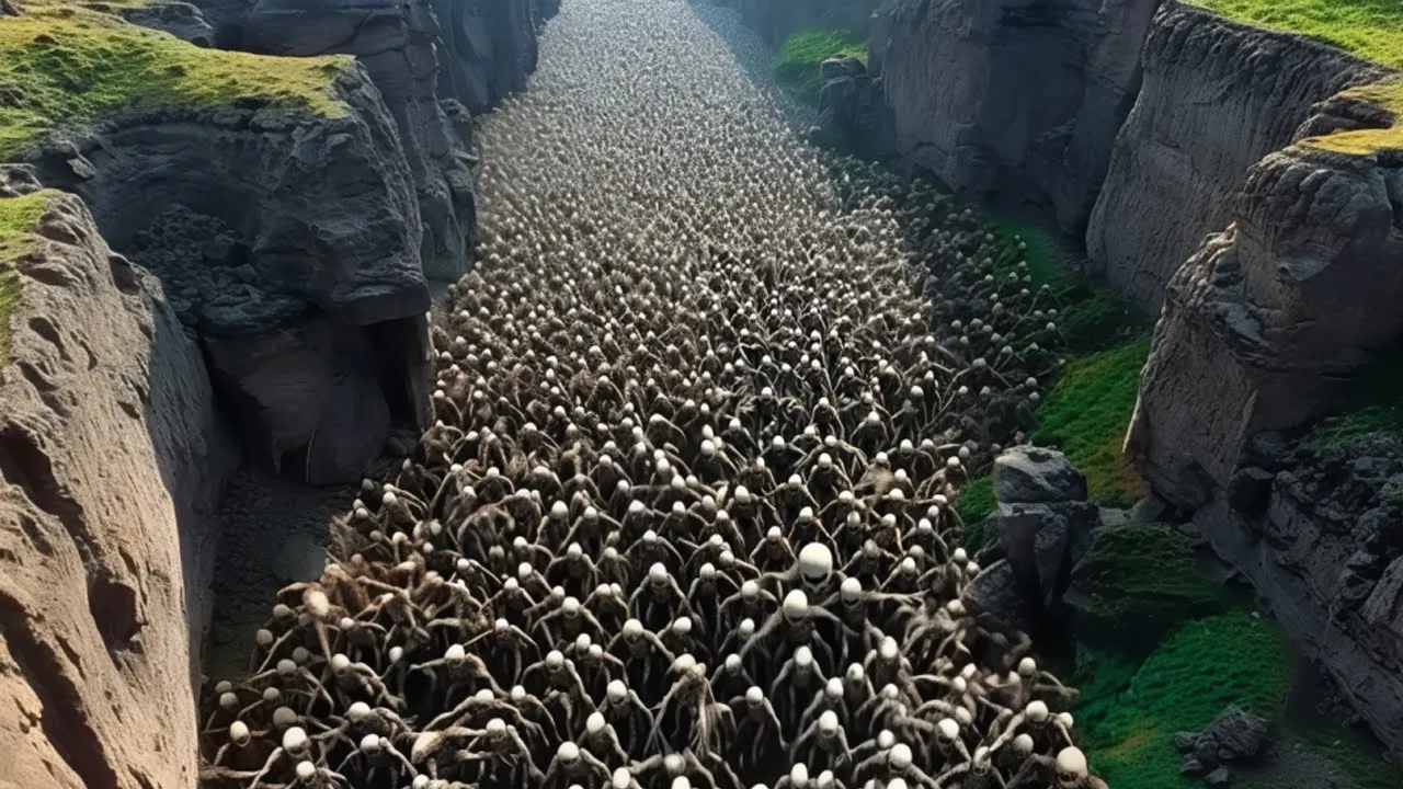
the spring that breathes is a must visit location for nature lovers because it provides a special Fusion of natural awe and scientific Fascination its remarkable Beauty and the Intriguing mechanics underlying its cyclical flow never cease to draw interest and Peak curiosity before we move on here's today's subscribers pick drone makes chilling Discovery in Canyon no one is supposed to see this this take a look at this astonishing image why are there so many skeletons and what catastrophic event could have caused this viewers what you see here are skeletons of animals and the sheer number is
truly astonishing The Remains appear to be those of sheep possibly decimated by a devastating disease most likely pneumonia we invite you our viewers to weigh into this mystery and help determine the exact species and the possible cause behind this haunting scene number five aramu muru portal aramu muru portal often referred to as the Gate of the Gods is a remarkable site that was recently taken by a drone in a remote area of Southern Peru close to the beaches of Lake tiaka this remarkable location comes up to its name offering a massive entryway carved into pinkish
Granite an incredibly unusual and mysterious site the aramu muru portal which is roughly 22 ft tall seems to be a work of old craftsmanship but its history is yet unknown the aramu muru portal is a spectacular example of precision cut rock with a rectangular shape and its absolute Grandeur has been brought to light by the Drone footage this structure's real creators are unknown and while some hypotheses suggest that extraterrestrials may have built it other theories provide more grounded answers some claim that the doorway was carved by the Inca or by pre- Ina societies like the
tiwanaku it is even thought that pachakuti the in Emperor may have traveled through it on route to Enlightenment furthermore myths about the area suggest that the portal is guarded by Supernatural entities or that it was formerly a place of shamanic ceremonies and may even be an interdimensional doorway though they are still theoretical these Concepts heighten the mystery surrounding the Gateway however in an effort to shed light on the aramu muru portal scientists have proposed that it might be a naturally occurring structure brought about by tectonic upheavals in the Earth's crust the aramu muru portal nevertheless
captures people's attention and piques their interest regarding its real Origins and purpose in spite of these scientific hypotheses number four Kalahari desert's fairy circles a recent drone survey of the Kalahari Desert has unveiled a breathtaking view of the enigmatic fairy circles that dot this Aid landscape these intriguing formations long known but only recently fully captured from above extend across 1,000 100 m of grassland the Drone footage reveals an astonishing pattern countless Barren circles surrounded by vibrant Lush rings of grass the fairy circles have sparked extensive debate regarding their origin for over 50 years two main
theories have emerged one suggests that termites are responsible altering the landscape in a way that creates these distinct patterns another theory posits that the circles are a result of the grass's evolutionary adaptation optimizing water in intake in the harsh desert environment in recent years ecologist Dr gutan has dedicated his research to unraveling The Mystery of the fairy circles with drone technology playing a crucial role his studies enhanced by aerial imagery suggest that the fairy circles are the result of a sophisticated water management system according to his findings the grass forms these circles as a way
to maximize water absorption through a natural vacuum system around its roots this new understanding offers a scientific explanation for the fairy circles Shifting the focus away from Supernatural theories and providing insight into the resilience and adaptability of desert Flora the Drone footage has not only showcased the Grandeur of this natural phenomenon but also deepened our understanding of the ecological mechanisms at Play number three a thousand-year-old village a recent thermal drone survey has uncovered fascinating details about the ancient Native American village known as blue jay in New Mexico this small drone equipped with thermal imaging technology
revealed structures that had previously eluded archaeologists although the village was first identified in the 1970s and is estimated to be around 1,000 years old this new data offers a fresh perspective on its layout and features located approximately 43 Mi south of chako Canyon blue jay was known to contain around 60 puebloan houses arranged around what was once a significant spring however The Village's ruins have have been challenging to study due to their burial under sandstone and obscuration by vegetation the recent thermal images may have uncovered AA a Subterranean circular structure used for ceremonial purposes this
is particularly intriguing as blue J does not feature the Monumental great houses or Subterranean kevas typically associated with Chakan AOS sites the presence of such a structure could provide new insights into the cultural and ceremonial practices of its inhabitants as archaeologists continue to study these new findings the thermal drone images are expected to shed more light on The Village's historical and cultural significance adding to our understanding of this ancient Community number two the gaju caves carved into the rugged Cliffs of the jundu mountains not far from Beijing the guahu caves stand as a remarkable Testament
to ancient Ingenuity this expansive network of over 110 interconnected Stone Chambers believed to date back more than a thousand years continues to Intrigue historians and archaeologists with its complexity and mystery the guyu caves feature a sophisticated arrangement of rooms windows and stone beds hinting at a well organized and potentially Advanced Society despite these insights the true purpose of these Cliff Dwellings and the identity of their Builders remain elusive some speculate that the caves might have served as a fortified military Outpost While others suggest they were a sanctuary for persecuted groups recent technological advances particularly the
use of drones have provided fresh perspectives on this ancient site high-resolution aerial surveys have revealed hidden Chambers and previously unknown Pathways offering a more detailed view of the Cave's structure and extent as research progresses these technological tools hold promise for uncovering the full history of the guahu caves and the enigmatic people who once inhabited them number one gunung Padang about 120 km from Jakarta on the Indonesian island of java is an ancient site called gunung Padang that has captured the attention of both residents and Scholars this location tucked up in the mountains might have Mysteries
that throw doubt on what we know about the past some people think that gunung Padang is proof of a highly developed culture that predates the Egyptian pyramid Builders gunung Padang has a modest appearance but it is a mysterious Mountain according to local tradition the rocks at this location have vitality and can even make music when struck these stories claim that striking specific rocks at the same time can produce a melodic concert of sounds the notion regarding What Lies Beneath gunung Padang surface is its Most Fascinating feature According to some researchers the mountain was created deliberately
over thousands of years by prehistoric people using volcanic rocks should this Theory be accurate the location may be as old as 20,000 years surpassing the age of the Egyptian Pyramids by more than 10,000 years Not only would such a finding be revolutionary but it would force a reassessment of the accomplishments and history of the early human race thanks for watching we'll see you in the next video in the next


![What We Discovered Buried Shocked The Whole World❌ [ Strange Treasure Hunt By Metal Detector ]](https://img.youtube.com/vi/69DWIyHfX3k/maxresdefault.jpg)