Imagine. A single door, not a symbolic door, a real physical gateway, 33 km wide at its narrowest point. And every single day, roughly 21 million barrels of oil pass through it.
That is about 1/if of the entire [music] world's daily energy consumption, squeezed through a gap barely wider than the English Channel. If that door slows down, fuel prices spike within hours. Economies feel it within days.
Supply chains that the modern world depends on begin to strain within weeks. We are talking about the strait of Hormuz. the most consequential strip of water on the planet.
A place where the world's [music] largest tankers navigate shipping lanes only 3 km wide. Where the balance of global energy markets can shift in a single afternoon. And where some of the most extraordinary geology [music] and most overlooked cultures on Earth exist almost entirely unknown to the outside world.
But here is what most documentaries about Hormuz miss entirely. Behind the tanker traffic and the energy economics, the straight of Hormuz is one of the most geologically extreme and culturally fascinating places on Earth. Islands with beaches of blood red sand.
A salt cave that stretches for 6 [music] km underground. ancient villages so isolated that their inhabitants speak a language found nowhere else on the planet. Mangrove forests that appear to float on the sea.
And a ship building tradition so [music] old and so precise that craftsmen still build massive oceangoing vessels from memory without a single blueprint. This is the straight of Hormuz, the world's most important waterway [music] and its most overlooked natural wonder. The fragile passage that powers the global economy.
Let's take a closer look. Pull up a map of the Middle East and find the Persian Gulf. It is that long narrow body of water stretching roughly 1,000 [music] km between the Arabian Peninsula on one side and Iran on the other.
Now follow it to its southern end. Watch the Gulf narrow. Watch the [music] two coastlines press toward each other.
Iran to the north, the Musandam peninsula of Oman to the south until the gap between them is only 33 km across. That is the straight of Hormuz. The numbers associated with this place are difficult to fully absorb.
Every day roughly 20 to 21 million barrels of crude oil transit these waters. That accounts for approximately 20% of global oil trade and about 25% of total liqufied natural gas trade. Saudi Arabia, the United [music] Arab Emirates, Kuwait, Iraq, Qatar, and Iran all depend on this single passage to [music] reach international markets.
There is no viable alternative route that can handle anything close to these volumes. If the straight of Hormuz were to close, the global economy would not simply slow down. It would seize.
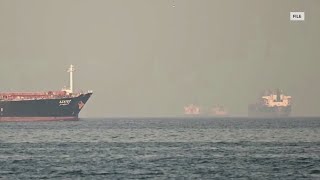
In practical terms, this means that the tankers passing through Hmuz every day are not just ships. They are a continuous financial lifeline. giant vessels, some of them among the largest moving machines ever constructed by human beings, carrying enough crude oil to power cities for weeks.
These super tankers, [music] known as VLCC's, or very large crude carriers, are up to 330 m long, [music] longer than the Eiffel Tower laid on its side, and they navigate shipping lanes that are at their narrowest only 3 km wide. 3 km in a straight that is 33 km across. The corridor through which 1/if of the world's energy flows is [music] by any measure remarkably narrow.
To understand just how concentrated the dependency [music] is, consider the individual countries whose economies depend on this gap. Japan imports approximately 90% of its oil through the strait. South Korea imports over 70%.
India, the world's third largest oil consumer, relies on hormuz for the majority [music] of its crude imports. China, now the world's largest oil importer, sends a significant share of its supply through these waters. The European economies increasingly reliant on liqufied natural [music] gas from Qatar route that gas through the strait.
This concentration of dependency [music] is not an accident. It is the result of 70 years of infrastructure investment built around a single geographic assumption that the straight of Hormuz would remain open. Refineries were built [music] to receive Gulf crude.
Pipeline networks were constructed to distribute it inland. Industrial economies were organized around energy pricing that assumed reliable access to Gulf supplies. The entire [music] architecture of global energy supply took the straight for granted.
There are alternative routes. The Petroline pipeline crosses Saudi Arabia from its eastern oil fields to the port of Yanbu on the Red Sea, bypassing the Gulf entirely. Its current capacity is approximately 5 million barrels per day.
The Abu Dhabi crude oil pipeline runs from interior oil fields to the port of Fujira on the Gulf of Oman. Its capacity is roughly 1. 5 million barrels per day.
Together, these alternatives can handle around 6 to 7 million barrels per day. Current daily transit through the straight runs at 20 to 21 million barrels. The gap [music] between available alternatives and actual traffic tells you everything [music] about how dependent the world remains on this one passage.
The International Maritime Organization maintains a traffic separation scheme in the straight. The maritime equivalent of lanes on a highway. Inbound traffic uses the Omani side.
Outbound [music] uses the Iranian side. Each lane is 3 km wide, separated by a 3 km buffer zone. Every major maritime nation has [music] agreed to these arrangements, and the system functions with remarkable efficiency given the volumes involved.
Hundreds of vessels transit every week. The logistics [music] of coordinating that traffic, preventing collisions between vessels the size of small city blocks and managing the complex tidal and current conditions of the strait is itself an extraordinary feat of international maritime cooperation. The straight of Hormuz [music] has been a critical trade gateway for far longer than the oil era.
For centuries before the first well [music] was drilled in the Gulf, these waters carried pearls, spices, textiles, incense, and timber between the civilizations of the Arabian Peninsula, Persia, India, and East Africa. The Dow trade that developed in these waters [music] was one of the great commercial networks of the pre-industrial world using the predictable [music] monsoon winds to move goods across the Indian Ocean on a seasonal schedule that merchants planned their entire year around. The oil trade is in that context the latest chapter in a very long story of commercial dependency on this geography.
This is the gateway that powers the world and it sits in one of the most geologically extraordinary places on earth. Now zoom in on the Iranian side of the straight [music] roughly 8 km from the port city of Bandar Abbaz. There is a small island there about 42 km population roughly [music] 6,000 people by all conventional measures unremarkable.
But step onto its beaches and your brain refuses to process what it is seeing. The sand is red, not orange red, not reddish brown in a subtle geological way. red, the color of brick dust, of something that should not exist on a beach.
Where other coastlines offer white or gold or gray, Hummus Island offers crimson. And when the waves [music] crash against that red shore, the water itself takes on the color, turning the surf a deep rust that looks in certain light almost otherworldly. The explanation [music] is geological, but no less extraordinary for that.
The island sits on a massive salt dome that has pushed upward through the Earth's crust over millions of years, carrying with it an extraordinary concentration of iron oxide [music] and dozens of other minerals. The soil contains up to 70 distinct mineral types. The iron oxide is so concentrated in the ground that it stains the water, the sand, the waves, and if you swim here, your skin for days afterward.
Locals know this ironrich red soil as golak, and they have been eating it for generations. [music] That is not a figure of speech. The red soil of hummus is genuinely edible.
Mixed with oil and spices, it is used as a flavoring in local cuisine. It is probably the only place on Earth where you can literally taste a [music] mountain. The same mineralrich earth that stains the beaches is also [music] used to produce cosmetics, ceramics, and fabric dyes.
It is an economic resource, though one that is becoming increasingly scarce as surface deposits are depleted and export [music] restrictions are tightened. Walk inland from the Red Beach and the landscape shifts constantly. The island is sometimes called Rainbow Island for good reason.
Within a few kilometers, the ground transitions through deep reds, bright yellows from sulfur deposits, patches of white [music] and purple and gray, as if a painter had spilled an entire palette across the [music] terrain. The colors change with the light. At sunrise, they are muted and complex.
By midday, they are almost violently saturated. At sunset they glow. This is Rainbow Valley, a natural [music] salt dome terrain that has no equivalent anywhere else on Earth that is quite so accessible, quite so visually extreme, quite so geologically [music] concentrated.
Artists who visit here during festivals use the colored sand to paint enormous ground murals that are visible [music] from above. Nature provides the pallet. They provide the pattern.
If Rainbow Valley is the island's painter, then the Valley of Statues is its sculptor. Wind and water have been working on the soft rock formations of Hormuz for millions of years, producing shapes that resist rational description. Columns that look like they are about to topple.
Arches that should have [music] collapsed centuries ago. Formations that, depending on the angle and the light, resemble dragons. Crouching eagles, [music] the weathered face of an old man.
Creatures from mythologies that do not quite exist in any known tradition. On windy days, the air moving through the crevices creates sounds that locals have described for centuries as the valley whispering or singing. After dark, most people do not go there.
And then there is what lies beneath. Hidden within the salt dome that underlies the entire island is a cave that locals call the salt goddess cave. It is formed entirely [music] of salt, a fact that makes it immediately unlike any other cave system most visitors have encountered.
The stallctites hanging from the ceiling are not limestone. They are crystalline white salt, sharp and luminous, catching any available light and scattering it [music] in all directions. The walls are dense and salt absorbing, which means the cave is acoustically almost dead.
No echo, no ambient sound. Only your own heartbeat and your own breathing amplified by the [music] silence around them. The air inside is extraordinarily pure, saturated with negative ions from the salt concentration.
People with respiratory conditions come here specifically to breathe. In a world of shipping lanes and energy markets, this cave is a different kind of place entirely. Dark, still indifferent to everything happening in the water above it.
There is also the [music] western salt cave whose walls are not white but multicolored. layers of salt stained by the same mineral diversity that colors the surface above. Red and orange and purple and ash gray.
A cross-section of the geological history of the island [music] rendered in underground crystal. The Portuguese fort on the island's northern edge stands as a reminder that Hormos was a critical trade gateway long before oil. For 500 years, it was defined by commerce of a different kind.
The Portuguese built this fort from local coral in the 16th century when controlling Hormuz meant controlling the maritime trade routes between India [music] and Europe. Inside the fort, a church was built below ground level to escape the island's brutal summer heat. Its arched vaults [music] and Gothic stone columns creating a space of improbable coolness and formality in the middle of one of the hottest places on Earth.
Bronze and iron cannons rusted by centuries of salt air [music] still point toward the sea as historical artifacts. They remind you that this straight has always been coveted by those who understood its economic importance. A few kilometers north of Hormuz Island, still within the waters of the strait, lies a much larger piece of land, Keshim Island.
1,500 kilm, over 130 km long, the largest island [music] in the Persian Gulf, home to roughly 150,000 people who live primarily from fishing, maritime trade, and a growing ecoourism industry that is only beginning to receive the international attention it deserves. Cheshum has [music] never tried to compete with the glittering modernity of the Gulf's larger cities. What it has instead is something considerably rarer.
A landscape that looks like it was designed by a geological process with no interest whatsoever in human expectations. Start with Chaku Canyon. From the surface, there is almost no indication that it exists.
You are walking across a flat, arid plane, and then the [music] ground simply opens. Vertical walls drop away on both sides, shooting up 30 m or more. Carved from limestone by wind and water over millions of years into formations that look like melted wax, [music] like fabric rippled by a breeze and then frozen.
The walls are so close in places that you can reach out [music] and touch both sides simultaneously. The canyon is cool in the shade of its own walls, even when the desert above bakes. Local tradition says the name means four [music] wells and the ancient watercatching holes carved into the canyon floor by generations of inhabitants are still visible.
This was not just a geological curiosity. This was a survival technology, a place where rainwater could [music] be stored against the brutal dry seasons. The people who built these wells understood their environment with an intimacy that modern engineering can recognize [music] but rarely match.
Then there is Stars Valley. Local legend holds that a star fell from the sky and struck the island here, throwing earth in every direction and leaving behind the bizarre landscape [music] of towering pillars, jagged spires and improbable arches that you see today. Geologists offer a less dramatic [music] explanation involving millions of years of differential erosion in soft sandstone.
But when you stand among the formations as the wind picks up [music] and the rock begins to produce its characteristic eerie whistling, the legend feels [music] more emotionally true than the science. The rock here is soft enough that every significant storm reshapes it. Visit today and the valley looks different from how it looked a decade ago.
It is a landscape perpetually in the process [music] of becoming something else. Go deeper into the island's southern reaches and you find something on an entirely different scale. The Namakdan Salt Cave, the longest salt cave on Earth.
Over 6 km of passages, chambers, and galleries formed as salt has pushed up through the island's geological layers over thousands of years. Walking into it means walking into a world made entirely of a single mineral. The walls are marbled [music] with red and purple and white.
The formations are salt stelactites hanging from the ceiling like white icicles. Salt rivers that look like frozen waterfalls, columns built by millennia [music] of mineral accretion. The air is considered therapeutically pure.
Some visitors come specifically for the respiratory benefits [music] of breathing salts saturated air deep underground. Others come because there is simply nothing else like it anywhere on the planet. High on a vertical cliff face above the sea, carved partly by nature and partly by human hands over 2,500 years, lies a maze of caves and tunnels that generations of island inhabitants [music] used as a refuge and lookout point.
The carvings on the walls span multiple cultures and multiple centuries. From one of the narrow openings, [music] you can look out over the straight and see the water below. The same view that communities here have maintained [music] for millennia, watching the shipping traffic pass in every era, from ancient Dowo trade to modern tankers.
At the Langanger shipyard, [music] enormous wooden vessels are rising from the sand as they have for over a thousand years. These are lingers, traditional Gulf sailing boats, some of them more than 30 m long. The craftsmen who build them carry no blueprints.
They consult no computer models. They work entirely from knowledge accumulated over generations, passed from father to [music] son in an unbroken transmission that UNESCO has recognized as an intangible cultural heritage of humanity. The wood is teak brought from India and Burma.
The tools are basic. The sound of the yard is a constant rhythmic percussion of wood on wood. These boats are built to last a century in salt water.
In a world of steelhulled container [music] ships and satellite navigation, wooden boats built from memory still work the waters of Hormuz. The village of Loft at the western end of Khim offers a different kind of wonder. It is one of the oldest continuously inhabited settlements in the Persian Gulf and its skyline is unmistakable.
Dozens of wind towers known as bad rising from the rooftops like a forest of rectangular chimneys. These are not decorative. They are an ancient air conditioning [music] system designed to catch the prevailing sea breezes and channel them down into the interiors of the houses below, dropping temperatures by several degrees without a single watt of electricity.
Loft has the highest concentration of wind towers in Iran. The technology is at least 1,000 [music] years old and still works perfectly. Behind the village, the ruins of Nadiri Fortress look down over the rooftops.
The towers, [music] the wooden boats anchored in the harbor, the deep blue sea beyond. And next to the fortress, a water management system of remarkable ingenuity. 366 wells, one for each [music] day of a leap year, dug by the ancient inhabitants of Loft and used in strict rotation.
Each day a single well was opened. By never drawing from the same source twice in a row, the community ensured that their freshwater supply was managed sustainably across the entire year. A water rationing system built without modern hydrarology operating on pure observational intelligence about resource depletion.
The women of loft wear masks called burka though these have nothing to do with the religious garment of the same name found elsewhere in the Islamic world. These are fabric face coverings originally designed to protect against sun and sandstorms. often brightly colored and intricately embroidered.
Some versions are styled to resemble a mustache, a tradition that originated as [music] a way to project a more formidable appearance to strangers. Whether or not the tactic ever worked, the masks remained. They are cultural identity made wearable.
Near Keshum, the small island of Hangam offers something different again. No cars, two small villages, crystal clear water, and dolphins. Not the kind you wait for, [music] the kind that find you.
A short boat ride from the pier and pods of Indo-Pacific humpback dolphins materialize alongside bow [music] riding, spinning, apparently as curious about you as you are about them. At night, when conditions are right, bioluminescent plankton light up the shallows, and the movement of a swimming body through the water leaves a trail of cold blue green light. Hangam is one of those places that remains for now largely unknown outside the region, which is precisely why it is [music] still like this.
Between Keshum Island and the Iranian mainland, in a region of shallow tidal flats that most people would pass through without stopping, there is a forest. This description does not adequately prepare you for what you actually find. The Har forest covers approximately 8,000 hectares.
It is classified by UNESCO as a world biosphere reserve. It is a mangrove forest. The dominant species being Avachenia Marina, the gray mangrove named after Ibansena, the legendary Persian physician and polymath by biologists who wanted to honor a tree as extraordinary as the scholar whose name it carries.
Twice a day, the Hara Forest performs what looks from a distance like a magic trick. When the tide rises, the sea advances through the root systems and the lower trunks of the trees disappear beneath the surface. The forest appears to float.
A dense canopy of green suspended above open water reflected in the still surface below. The boundary between tree and sea dissolved entirely. From a boat moving through it, you look up at leaves and sky and look [music] down at their perfect reflection in the water below.
And for a moment, the world has no floor. When the tide falls again, the water retreats and reveals what was always there. An intricate tangled architecture of roots deeply embedded in the salt mud.
The roots arch and twist and interlock like a natural sculpture, gray and wet and alive. Covering the tidal [music] flat in a network of organic engineering that stabilizes the sediment, breaks the force of waves and protects the coastline behind it from erosion. The trees survive in conditions that should kill them.
Their root systems are submerged [music] in salt water twice daily. Normal plants would die within days. Aviscenia Marina has evolved what is effectively an internal desalination system.
The bark filters out salt [music] as water is absorbed, allowing only fresh water to enter the treere's vascular system. Excess salt is then secreted through the leaf surface, leaving a faint crystalline residue that you can taste if you touch a leaf to your tongue. The tree drinks the sea and expels the salt.
It is a biological process so elegant and so effective that environmental engineers have studied it seriously as a model for artificial desalination technology. A tree that [music] has been doing what expensive modern infrastructure tries to replicate reliably for millions of years. Beneath the surface of the water, threading through the root systems, the Harra forest functions as a nursery for fish, shrimp, and sea turtles.
The tangled underwater architecture provides shelter and feeding [music] grounds for juvenile marine species that will eventually move out into the wider Gulf. The roots trap organic debris and sediment, creating nutrientrich conditions that support the base of the food chain. Researchers have documented that mangrove forests globally [music] produce fishery yields far beyond what their surface area would suggest because so many commercial fish species spent their early life stages [music] in exactly this kind of habitat.
The Har forest is in a very direct sense producing the fish that the people of Khim and the mainland coast have been eating for generations. destroy the forest and you destroy the productivity of the surrounding sea. The two are not separate systems.
They are the same system. Above the waterline, the forest is a critical stopover for thousands of migratory [music] birds traveling south from northern Asia each winter. Flamingos arrive in flocks large enough to turn the shallows pink.
Greater and lesser flamingos feed side by side in the tidal zone. Egrets and herand stand motionless in the channels waiting. Pelicans patrol overhead.
Rare species of raptor nest in the upper canopy. And at night in certain seasons, the water glows. Bioluminescent phytolanton bloom in the nutrientrich tidal [music] channels.
And the movement of a boat through the water produces a trail of cold blue green light. A paddle stroke lights up. Fish darting away leave luminous wakes.
When conditions are right, the har forest at night becomes something almost impossible to describe. The canopy dark above, the water [music] glowing below, reflections making it impossible to tell where the light ends. You can only [music] enter the Hara Forest by boat.
Narrow wooden vessels navigate through the channels between [music] the trees, the canopy closing overhead in places, the sound of the open sea replaced by bird song [music] and the soft sound of water against the hull. It is one of those rare experiences that is genuinely difficult to reconcile with the geography surrounding it. A UNESCO biosphere reserve of extraordinary ecological complexity.
A few kilometers from [music] one of the busiest shipping lanes on Earth. The tankers pass. The mangroves grow.
The tides come and go. The flamingos arrive in November and leave in spring. The forest does not know about the oil.
Shift perspective now. Cross the straight to the Omani side. The Musandam Peninsula is the piece of Oman that juts northward into the straight of Hormuz, separated from the rest of the country by the United Arab Emirates.
It is a landscape of vertigenous limestone cliffs, deep fjords that look imported from Scandinavia, and communities that have had almost no contact with the [music] outside world for most of their history at the very tip of the peninsula. Accessible only by boat or [music] helicopter, no roads reaching it through the mountain ranges that surround it on every side is a village called Kumza. About 2,000 [music] people live here.
Their houses are packed tightly together because flat land is almost non-existent. The village is a thin strip of settlement [music] wedged between cliff and sea with houses built up the slope wherever footings can be cut into the rock. The narrow [music] alleys between buildings are cool even in summer because the walls are close enough to block direct sunlight for most of the day.
From the waterfront, the giant oil tankers passing through Hummus are visible on the horizon as enormous slowmoving structures. A surreal juxtaposition of one of the most isolated communities on the planet looking out daily at one of the central arteries of the global economy. Kumzar's most extraordinary feature is its language.
The people here do not speak standard Arabic. They speak Kumari, a language found nowhere else on the planet. Linguists who have studied it describe it as a blend of at least 10 different languages, including Arabic, Persian, Portuguese, [music] Hindi, Baluchi, Swahili, and several others that reflect centuries of maritime traffic through these waters.
Every time a trader, a sailor, a merchant passed through Hormuz and made contact with Kumza, they left a small deposit of vocabulary, a Portuguese word for a type of rope, a Hindi term for a spice, a Persian construction for expressing time, a Swahili phrase that traveled 3,000 km north [music] on a Dao. Over generations, these deposits accumulated and fused into something that is not any [music] of its source languages, but is all of them simultaneously. Kumzari is a linguistic fossil of the straight of Hormuz itself.
A living record of every culture that has passed through this water over the past 5 centuries, preserved in the mouths of 2,000 people who live beyond the reach of any road. Linguists consider it critically endangered. The younger generation is increasingly exposed to standard Arabic through schooling and digital media.
The language that took five centuries of maritime history to assemble could dissolve in a generation. Life in Kumza [music] has always been organized around two realities. The sea and the heat.
The village faces the water because the water is everything. Food, transport, livelihood. And every summer when the temperature inside the village climbs to levels that the surrounding cliffs trap and amplify, the community does something remarkable.
It migrates entirely. From approximately June to September, almost the entire population of Kumzar closes its doors, [music] loads its families into boats, and travels to Casab, the main town on the Musandam Peninsula, to harvest dates and escape the heat. In the autumn, they return together as one community.
The migration has been happening for as long as anyone can remember. It is seasonal, collective, [music] and precise. A perfect example of a community that read its environment [music] and adapted rather than trying to fight conditions it could not change.
The Shihu tribe, the indigenous people of Musandam more [music] broadly, reflect the same orientation. They built their villages on cliff ledges accessible only by sea or by goat tracks. They developed their own dialect distinct enough from standard Arabic that Gulf Arabs sometimes need an interpreter.
And they carry the yuz a small [music] axe used as walking stick, farming tool and social marker. You can identify a shih who man by his jers identity compressed into a single object from the summit of Jebelharim, the highest peak in Musandam at approximately [music] 2,87 m. The full geography of the strait becomes visible.
The limestone mountains dropping to the fjords. The fjords opening to the Gulf of Oman. The straight itself in the haze at the horizon.
The tanker traffic just visible as slow shapes. And embedded in the rock all around you at 2,000 m elevation. Marine fossils, fish, coral, shells pressed into limestone.
This entire mountain was once the floor of an ancient sea. Tectonic forces [music] pushed it skyward over tens of millions of years. The fossils are a record of that transformation, preserved in stone at an elevation that makes their presence almost impossible to process.
In winter, temperatures at the summit can drop low enough for frost to form on the rocks. In a landscape that is desert at its core, at the edge of one of the most important sea routes on Earth, frost forms on the clifftops of a peninsula, jutting into the straight of Hormos. Deep in one of the Musandam fjords, a tiny island holds a curious piece of history.
In 1864, the British built a telegraph station here as part of the undersea cable network connecting London to India, the most ambitious communications infrastructure of the 19th century. The operators stationed on what became [music] known as Telegraph Island worked in almost total isolation. The fjorded walls trapped the heat.
There was nothing to do but transmit messages for an empire thousands of kilometers away. The station was abandoned after just 5 years. The ruins are still there today, small and crumbling on their rock.
The water around them is crystal clear, full of coral and fish. It is now one of the most popular snorkeling spots in the Muzam Fjords. The irony is complete.
The straight beyond oil. Here is a question that the energy industry has been quietly wrestling with for years. What happens to the straight of hormuz when the world no longer needs as much oil?
The energy transition is real and it is accelerating though unevenly. Electric vehicles are growing from a fraction of the global car fleet to a meaningful share. Renewable energy capacity is being added globally at a pace that would have seemed impossible a decade ago.
Major economies are setting legally binding targets for decarbonization that if met would require dramatic reductions in petroleum consumption within the [music] coming decades. For the Gulf States, this represents an existential economic [music] challenge. Saudi Arabia, the UAE, Kuwait, and Qatar [music] have all launched major economic diversification programs designed to reduce their dependence on oil revenues before the demand curve turns permanently downward.
Saudi vision 2030 aims to build a tourism industry, a technology sector, an entertainment [music] economy, and a manufacturing base capable of sustaining the country's finances in a post oil era. The UAE has invested aggressively in renewable energy, finance, logistics, and aviation. Qatar has used its [music] LNG revenues to build one of the world's most active sovereign wealth funds, positioning itself to generate returns from global investments rather than resource extraction.
These transitions are genuine, but they are also slow relative to the timelines that climate scientists say matter. For the foreseeable future, and foreseeable here means several decades, the straight of Hormuz will remain the most important energy corridor on Earth. The oil keeps flowing, the tankers keep moving, the dependency holds, but the nature of what [music] transits the straight is already changing.
Liqufied natural gas is growing as a share of total traffic. As the world's power sector shifts from coal toward gas as [music] a lower carbon transition fuel, hydrogen, which many energy analysts see as a critical component of a genuinely decarbonized economy, may eventually become another export from the Gulf. The region has the solar energy potential to produce green hydrogen at competitive cost and the existing port infrastructure to export it.
The strait that carried pearls and spices before it carried oil may eventually carry hydrogen and ammonia as the energy economy continues its slow rotation. Climate change is adding its own pressure to the region. The Gulf States are among the most heatstressed places on Earth.
Temperatures in summer already exceed what the human body can safely [music] tolerate outdoors without cooling. The combination of extreme heat and high humidity that characterizes Gulf summers is intensifying. By midentury, under current projections, conditions in parts of the region during summer months will present genuine challenges for outdoor activity and infrastructure.
The Gulf States are investing heavily in adaptation, desalination, energyefficient cooling systems, green building standards. But the underlying trend is toward a hotter and more challenging climate. For the natural environments around the strait, climate change is also a significant concern.
The coral reefs of the Persian Gulf are among the most heatstressed marine [music] ecosystems on Earth, having already survived temperatures that would bleach and kill reefs elsewhere, but facing increasing pressure as the baseline temperature rises. The mangrove ecosystems like the harra forest which provide critical ecological services are vulnerable to sea level rise and changing tidal patterns. The species that depend on these habitats, the flamingos, the sea turtles, the juvenile fish that grow up [music] in the root systems face uncertain futures.
The ancient geological [music] wonders of Hormuz and Keshum Islands will persist on any human [music] time scale. Salt domes take millions of years to form and millions to dissolve. The red beaches will still be red.
The salt caves will still extend underground. The mineral colors of Rainbow Valley will still shift with the light. These are features of deep geological time and human activity will not alter them within any time horizon we can meaningfully imagine.
But the human cultures of the strait, the [music] Kumzari language, the langanger ship building tradition, the wind towers of loft, the seasonal migration of Kumza, the masks of the women of Khim. These are more fragile. They depend on communities choosing to maintain them, on economic conditions that make traditional livelihoods viable, and on the kind of isolation that has historically protected small distinctive cultures [music] from being absorbed into larger homogeneous ones.
Connectivity, which the modern world treats as [music] an unambiguous good, can dissolve cultural distinctiveness as surely as physical change. The straight of Hormuz is changing. The region around it is changing.
The energy economy that made it famous is changing. And the extraordinary natural and cultural heritage that [music] exists almost invisibly alongside the tanker traffic is changing, too. Zoom back out.
Think about everything this 33 km gap contains. The blood red beaches of Hormuz Island stained by 70 minerals pushed up from inside the Earth. The longest salt cave on the planet.
Its walls [music] multicolored and its air acoustically dead. The Rainbow Valley where the soil is literally edible and changes color every hour. The Chaku Canyon, where ancient watercatching holes carved by hand into [music] the canyon floor, still tell the story of communities that survived here through ingenuity rather than abundance.
The floating mangrove forest that drinks salt water and expels it [music] through its leaves. That is simultaneously a biological wonder and a living ecological infrastructure on which the fisheries [music] of the surrounding sea depend. The ancient [music] village where people speak a language assembled from 10 others over five centuries of maritime history.
The fossil fish and coral visible in rock at 2,000 m elevation. The shipyard where massive oceangoing vessels are still built from memory without blueprints. And threading through all of it, the super tankers, 20 million barrels a day.
The energy [music] that keeps the lights on in cities from Tokyo to Toronto, passing through a gap that most of the people whose lives depend on it could not locate on a map. The straight of Hormuz is by any contemporary measure the most consequential stretch of water on earth. And it is simultaneously one of the most geologically extreme, ecologically extraordinary and culturally underexplored places the planet has to offer.
These two facts are not contradictions. They are the same reality described from different angles. The energy economy that makes the strait strategically important is approximately 70 years old.
The cultures that exist around it are thousands of years old. The geology that underlies it is millions of years old. The oil trade is the latest episode in a very long story and viewed on geological time, a brief one.
The salt goddess sits in her cave in the dark in absolute silence, entirely unbothered by the tanker traffic passing through the water above her. The mangroves drink the sea and grow. The flamingos arrive in November as they always have, and the Kumsari language carries its cargo of 10 languages and five centuries of maritime history [music] in the mouths of 2,000 people at the edge of the world's most important waterway, waiting to be heard by anyone paying attention.
The fragile passage that powers the global economy was here long [music] before the global economy existed. In some form, it will be here long after. The question is [music] what we notice while both are still running.