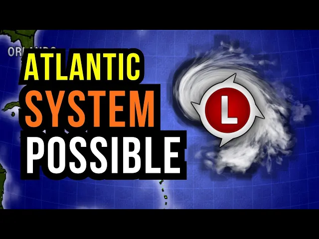
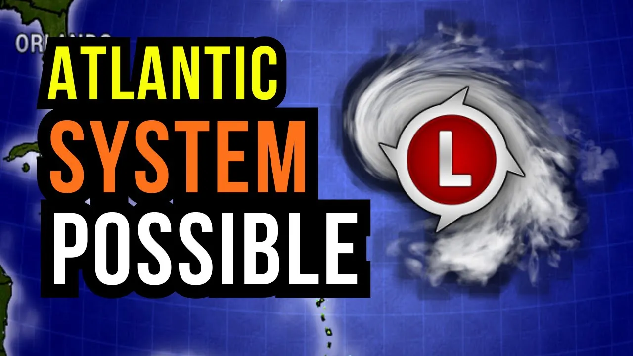
thank you very much for joining me I hope you're doing well I'm meteorologist Brian Shields an Atlantic spin up is possible there could be some development out there in the Atlantic sometimes this happens this time of year I want to show you why kind of what it means for down the road and what we have is these big fronts that are rolling by we have a leftover front in the Caribbean that's front number two front number two the Atlantic region of Canada Northeast of the us a lot of snow that's been pulling into spots cold
air another front moving by in this time of year even though we're out of the hurricane season they could leave leftover moisture in parts of the Atlantic and that's where sometimes usually every other December or a little bit uh even more rare than that uh uh we get something trying to spin up in the tropics now it's not going to be truly tropical in nature could it become a name system yeah but uh it's most likely some sort of subtropical system there's a lot of science behind that but uh uh basically not truly uh tropical
uh in nature but let me show you where we could get this spin up let's go out in time here this is by Monday by Monday another front's going to be working its way off the Atlantic region of Canada back through the United States and the gulf now these other fronts that I moved by leave a little moisture behind look at that spot right there so here we are in the Caribbean you can see that green right there in the Atlantic that's the spot to watch for the possibility of some development so this is by
early next week let's go out in time further this here is the American model I want to show you the European model and the environmental condition conditions in just a moment by Wednesday of next week so we're looking at about 6 days from now look at all that moisture here's Bermuda just to the east or southeast of Bermuda that's where there could be something some sort of storm system subtropical in nature trying to develop now there should be another front coming across you see here by the time we get deeper in the next week this
is over a week from now another front starts to move across the Western Atlantic and it may take this Spin and kind of lift it up to the north now if this area does develop some again here we are in the Caribbean Bahamas right here if this area does develop it should be kind of Broad in nature it's not going to be a hurricane or anything like that uh but even if it did become a subtropical storm that just means kind of a broader Windfield on this some Gusty winds some high seas in the Atlantic
then there'll be colder air again sweeping behind this front but if this front is a little slower this area May drift a little bit more toward the west and that could increase our chance of some gustier winds in the Caribbean and maybe even increase our chance of some rain by the time we get into the end of next week now here's the European model the Canadian and even the German models are showing a similar spin in the Atlantic so here's one front right here here's the other front we have across the Caribbean there's that extra
rain which we've been watching in Central America I'll Zoom down uh into that in just a moment with those rain totals but here's that European model so here we are in Jamaica down through Trin and Tobago Barbados Puerto Rico just to orient you let's go out in time here this is a week from now this is by uh late next Wednesday and early Thursday of next week here comes that other front right here this one's going to be a really strong front moving through the us toward the Bahamas and the Caribbean but there's that green
on the map right there there is that spin and for the most part should be off to the uh east of us but if this front slows down that spin that storm system could kind of drift our way the European model has it closer so this here would be by the end of next week so this here would be 78 days from now and you can see very similar though to the American model right here comes that front this front may be a little bit slower a lot of cold air back behind it moving in
and we'll highlight that further in upcoming videos uh the Christmas winds moving in for more of us but that spin you can see it building closer to the Caribbean by late next week and it may actually enhance our chance of rain in the northeastern Caribbean and give us those higher C's and then eventually by next weekend this front should move in and kind of draw whatever this area is up to the north so what we're going to do over the next few days and I'll update you is just kind of monitor how close the storm
system could get don't expect it to be a really a big impact system or anything like that but it may bring us as I mentioned some additional rain if it gets close enough and some gustier winds later next week but either way the the seas are really going to build with this kind of broad area just just big area of low pressure out here low pressure meaning a storm system out here here is Bermuda and then I'll watch out how close it does get to uh Bermuda too so we've got some stuff to attract as
we go forward now the water temperatures uh in the Caribbean still relatively warm 28 29 even pushing 30° cels in spots so any where from about 84 to 87° f as a whole other spots a little warmer other spots a little bit cooler we've cooled down in the western Atlantic and in the Gulf of Mexico uh big time especially closer to the coastline those water temperatures have really dropped uh a lot of them in the 60s uh at least uh Fahrenheit uh 26 uh maybe uh 24 25 degrees celsi but out here in the open
Waters of the Atlantic the numbers are running above average this here is the water versus kind of the water temps versus average anywhere where you see this red shading or kind of orangey and yellow shading which is most of us Atlantic Caribbean and the Gul those are above average water temperatures now that doesn't mean this spin is going to uh develop into a hurricane but with these above average water temperatures that can add a little more fuel and that's why I do believe there is the possibility that this does become a subtropical system just because
the water temperatures are running a little bit above average may add a little bit more fuel to this uh and kind of allow it to to spin a little bit more uh if you will so if this does eventually get a name again it is not likely uh but occasionally get something out there in the Atlantic in December even in January sometimes that happens that happened a couple years ago uh Tony would be the next name on the list so maybe subtropical storm Tony not likely uh looks like we'll end out uh the year on
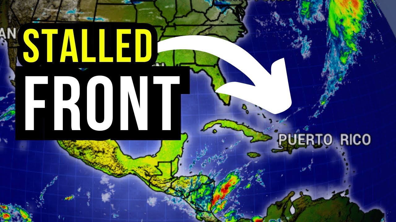
Sarah but if it if we do get some kind of Rogue system out there uh Tony would be the next name on the list now the hurricane season ended at the end of November but we keep the same list through the end of the year January 1st that's when the new list kicks in and then the hurricane season starts June 1st of next year so the list stays the same all the way through the calendar year now we have that front across the Caribbean there's still some of that rain we've had those areas of rain
just very unsettled across Central America Honduras over toward parts of Nicaragua here's the front that could give us a couple spotty showers more though Honduras and Nicaragua and watching our Islands just offshore and then as we work our way into the Eastern Caribbean it's not going to be a wash out for us but every now and then some of our Islands could get some rain we could get some of those passing showers just with easterly flow this here is tomorrow tomorrow afternoon there's that front but there's a little bit of that green you see some
of us could get some of those passing showers St vce the Grenadines even up towards St kits and neas in that front just kind of lingering giving us those spotty showers Turks and caos Jamaica parts of Cuba Haiti Dominican Republic still the higher chance of rain overall Nicaragua and Honduras watching up for the flood thread and that generally holds into Saturday Saturday I'll monitor how close some of this rain gets to Le spotty showers elsewhere and there we go Barbados St Lucia Dominica we could get a couple of those scattered showers down through Grenada St
Vincent and the Grenadines just with that easterly breeze that will be with us now the seas are going to stay on the choppy side that is common for this time of year through the Caribbean really building with that NE system that's moving off the coast of the United States that's moving off right now very dangerous Seas uh near Bermuda over the next couple of days this is by tomorrow across the Caribbean two maybe 3 meters so uh looking at 5 6 7 ft could be a little bit higher in some spots and this here is
by the weekend so monitoring uh those Waters a little bit tricky this time of year trying to do some sailing kind of getting in between uh some of these uh fronts to try to find some uh settled Waters now here's that front in the Atlantic region of Canada this is one of those fronts that's going to leave that leftover moisture and then we'll watch out to see if that Atlantic uh spin that Atlantic system does happen as we get into uh next week you could see some of the rain at times passing through Bermuda and
of course watching it passing through New Finland back toward New Brunswick Prince Edward Island Nova Scotia and then coming right out of uh Quebec that cold weather back behind it huge lake effect snow has been an issue in some spots and still even as we work our way into Saturday watching out just with that strong northwesterly flow and some leftover moisture some leftover snow will be a possibility as we head into the weekend but here's that front lingering here so some spotting showers possible extreme Southern Bahamas Turks and caos we may get an inch or
25 millim of rain if we get a couple repeat showers could be a little bit more watching out for a couple of the spotty showers Jamaica mainly dry for us in the Cayman Islands best chance of getting any rain in Haiti would be pter Prince to the north Dominican Republic as well North Side better chance of rain just closer to the front but you see the blues on the map that's telling me our rain Chan is not too high and if we do get a shower maybe a quarter to half of an inch of rain
10 mm of rain in some locations but I showed you that easterly flow you see a little bit of the way of pink and purple popping up that's that moisture that's going to build in from the East to the West so we could get a couple spots getting 50 millim of rain or 2 Ines of rain not many of us but a few of us as we work our way uh into uh the end of the week through the end of the week into the weekend Guyana seram that rain chance has gone down but there
are those higher totals the models are trying to put out a lot of rain the next few days in Honduras now I've been highlighting this I think for about seven eight days so you're well prepared for the possibility of flooding I've been watching that in Honduras and nicar Nicaragua even parts of Costa Rica and I've been highlighting that it's closer to the water where we'll see some of those higher totals of over 100 millimet of rain or 4 Ines of rain and some of this could nudge close to bise but staying generally just off to
our Southeast and with fronts moving by Texas and Mexico could see a little bit of rain so about a 50% chance for us today in Jamaica a 40% chance tomorrow back to a 50% chance on Saturday so some of us stay dry others we get some scattered showers Cayman Islands though were generally dry rain chance 10 to 20% 20% chance today Trinidad and Tobago with an easterly Breeze 30 to 40% chance as we get into the weekend 30 to 40% chance the next few days in Barbados tomorrow and Saturday rain chance will be up to
40% in isolated showers possible in St Lucia the next few days into the upcoming weekend rain chance 30% today in Grenada a 40% chance tomorrow a St Vincent the Grenadines 30% chance today tomorrow into the weekend a 40% chance of some spotty showers rain chance in Martinique the next three days at 40% 40% as well in the Dominican Republic and or excuse me in Dominica and we're going to see some Gusty winds at times 40% chance of rain guadaloop over the next couple of days 40% chance Antiga Barbuda today 20% chance for tomorrow 40% chance
today St kit Nas and moner out isolated shower one or two possible tomorrow in through the upcoming weekend 20 to 30 % chance into the upcoming weekend Anguilla and St Barts rain chance holding at 30% St Martin Saban Stasia today tomorrow on Saturday and a 20 to 30% chance of an isolated shower in Puerto Rico some of us need to get some rain we do that again us and British Virgin Islands rain chance today 30% just a 20% chance of a passing shower tomorrow but a lot of us deal with some windy weather Bahamas were
mainly dry we get back through the Turks and caos could get a couple of those showers with that front now in the Dominican Republic uh Northern sections better chance of rain same thing in Haiti Northern sections better chance of rain about a 20 to 30% chance 20% chance today in B up to a 40% chance though on Saturday some of that moisture near Honduras will start to work in to our Southern zones Aruba kir s Bonair we may get a passing shower let me know in the comments but the rain chance is not super high
and the rain chance has gone down in Guyana it's also gone down in that rain chance very minimal a lot of us staying dry as we get into the upcoming weekend Cuba we've had some of those cool nights those cooler days and we've been drier rain chance 40 to 50% Costa Rica and Panama a little higher though as we get back toward Nicaragua and in Honduras and monitoring the chances of flooding all the way into the upcoming weekend Guatemala and El Salvador rain chance 20% today 30% chance tomorrow mainly dry right across Mexico City we
mainly dry across the Yucatan Peninsula of Mexico and a 30% chance of rain in Northern Columbia 20 to 30% chance the next 3 days in Northern Venezuela and just watching that next front moving into Bermuda that'll sweep through that chance of some rain showers Gusty winds and those higher Seas so in Central America Honduras and Nicaragua watching that flood chance tracking these two fronts one in the Caribbean one to the North and then eventually in the Atlantic we could see something trying to develop at the least some gustier winds higher seas and they'll monitor how
close that storm system gets to the Caribbean as we go forward thank you for being with me and I hope you have a great rest of your day