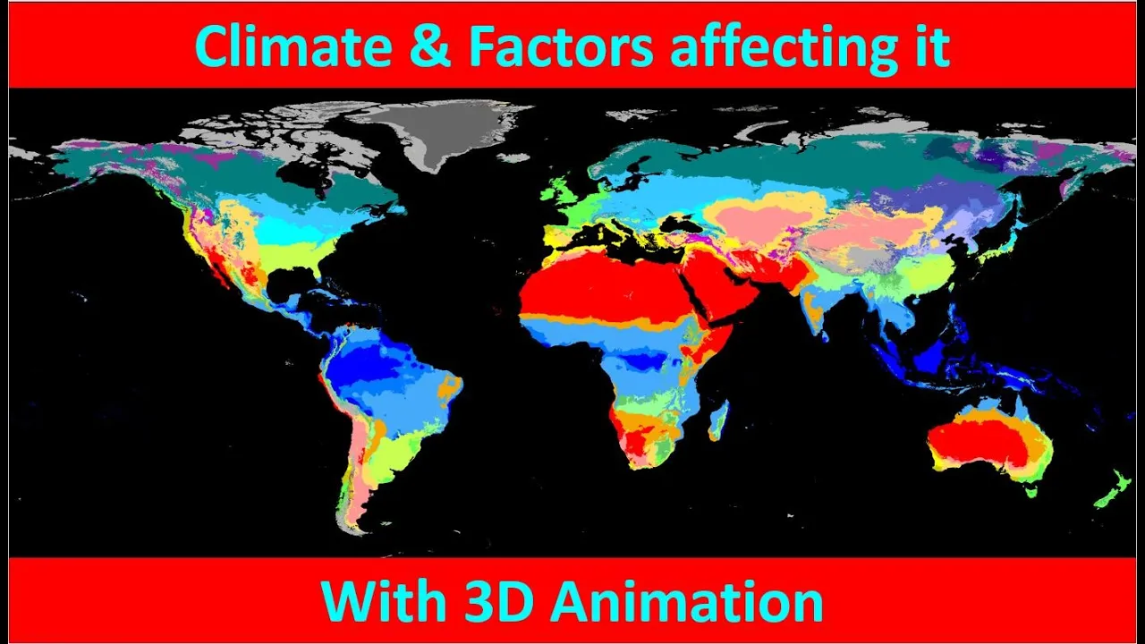
[Music] Hello friends welcome to another video of Z today we going to discuss about the factors AFF climate of a region so let's first understand what is the difference between weather of a region and climate of a region the weather is a day-to-day varation in atmospheric conditions of an area while the climate is more of an average or a long-term average are prevailing in the region so to understand the difference if we take the example of T desert then it will always be classified as an arid climate region even though if there is a rain
in that region we will say that on that day when there is rain we will say that the T desert has a rainy weather but we cannot say that it has a rainy climate so a region can have a rainy weather on one day a hot weather on another day and a cold weather on the third day but that region cannot have a hot climate on one day and cold climate on another day so climate is a general classification of a region it is an average over a very long time so if a region is
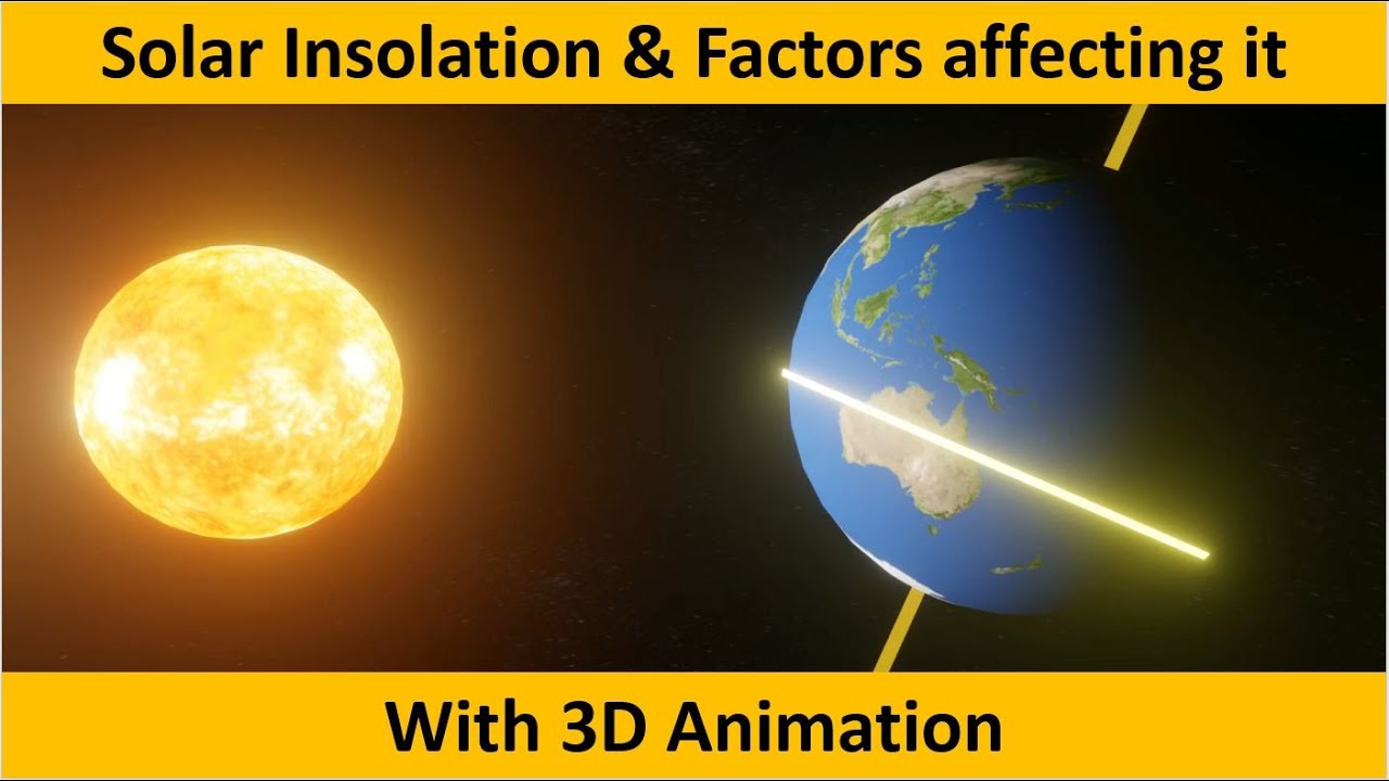
classified as hot it will always be called as hot climatic atmosphere for that region even though there is cold for a particular day in that region while for the weather we can use all the terms based on the weather or based on the atmospheric conditions on that day so why do we have climates why are there variations in the climate and the reason is that the Earth rotates around the sun on an inclined axis as we can see over here this is the top view this is the front view and this is the side view
so we can see that this line indicates the region which is directly facing the Sun so as our Earth it continues its revolution around the Sun in this orbital path we will see that different regions will have sun facing directly here it is in northern hemisphere now as the Earth will start to move from June to September we will see that it comes to the Equator so now the equator is directly facing the raise of the sun while North Pole and South Pole both are receiving sunlight but as we receive December this region will move
in the southern hemisphere that is now the southern hemisphere is directly receiving sunlight from the Sun and the North Pole is completely dark for 6 months while the South Pole will have daylight for 6 months so we can see that the amount of solar insulation or solar radiation that is received by a region on the earth varies across the year du to this elliptical orbit as well as the inclination of Earth on its axis sometimes Northern Hemisphere will receive more sunlight that is in the June month while in the December the southern hemisphere will receive
more sunlight so when it receives more sunlight that region will experience summer like conditions while the region that it receives less than light then it will have winter like climate and that is why based on the position of the Earth in this orbit the climate changes for a region so these are the various factors which which determine the climate of a region and we will see each of them one by one the first is latitude if you are near the equator then the sunlight will be directly falling on you while when you are closer to
the polar regions then the sunlight will be inclined the sunlight which falls directly is concentrated it has more intensity it has more capacity of heating this region while the sunlight which comes incline it does not have that much heat capacity to heat the region therefore it cannot raise the temperature of this region as as much as this can increase here we can see that there are beams of sunlights which are emerging from the Sun these sun rays are emerging from the Sun and reaching over Earth now remember the sun is actually much larger than Earth
but because of the amount of distance between the Sun and the Earth we can consider the Sun as a point source and here we can see that some of the rays are received by Earth are inclined R are received directly these are directly received by the this isial region where it receives Direct sunlight while here it is inclined now here we can see that it travels for a longer distance in the atmosphere which is indicated by this thin transparent layer so it covers larger distance in the atmosphere compared to the rays which are coming over
here and because it is traveling for a larger distance there will be more absorption and scattering remember we have seen in the heat budget class that the atmosphere absorbs the incoming solar radiation in the form of ozone or oxygen or weaper we saw this kind of diagram where the incoming solar radiation is absorbed by various gases which are indicated over here this is their capacity to absorb the incoming solar radiation and there is this cattering this is Relic scattering so we can see that incoming solar radiation also experience this incoming this Rel scattering now moreover
the area of the Sunray but if you take the same thickness of sunlight coming to the polar regions then it will be spread over larger area and therefore the heat capacity of the Sunray over here decreases because now it is heating a very large area compared to the sunr Rays reaching in the equatorial region now the next factor which affects the climate of a region is latitude as we have seen that the sunlight in the polar regions is inclined so if you more closer to the polar region then will at or the colder the climate
and if you're closer to the equitorial region then you will have more higher temperature so we have seen the latitude influences the amount of solar radiation that you will receive throughout the year this indicates the region which is directly facing the Sun and throughout the year this location will move across the globe it will move north and will move South however there is a foundation of this region and which we can see over here so here if you see the region that is directly facing the sun it will to the maximum reach over here in
the northern side that is it passes through Gujarat or this point is called Tropic of Cancer in the South it will reach maximum to the Tropic of Capricorn it is only this region which will face direct sunlight once in a year or twice in a year at Equator so this region will receive direct sunlight so it will have higher Heating and so this will have warmer climate sunlight because the sunlight is receiving incl in this region and therefore these regions will have colder atmosphere if you go at the poles then there is 6 month of
daylight however the light is very inclined therefore it does not provide that much heating while it has six months of no daylight so in that there is excessive cooling of the region so we will see that the polar regions are excessively cold compared to the equatorial region the second important factor that affects the climate of a region is its altitude that is height above the sea level here we can see that as we go upwards the pressure decreases pressure continuously decreases as we move higher from the sea level and we know that the temperature is
directly proportional to pressure as the pressure decreases with height the temperature will also decrease that is why regions on mountains have lower temperature so the height or the altitude is also an important factor which determines temperature of a region then distance from oans also plays an important role in determining climate of a region and the reason is that water has high heat capacity while land has low heat capacity now specific heat capacity is basically the amount of heat that must be added to one unit of mass of substance in order to cause an increase of
one unit increase in temperature so basically it means that it is the amount of heat you require to heat a one unit of an object by 1° CSUS because the heat capacity of water is higher therefore it can absorb higher amount of heat without increasing its temperature while the specific heat capacity of land is very small therefore even small amount of heating can change its temperature and similarly a small amount of loss of heat will change its temperature here we see that this region is closer to the oceans and because the oceans have high heat
capacity we can see that it has temperature compared to the this is the relative temperature profile here it is cooler compared to the land area however in the nights if we see this region is warmer because it does not change its temperature so it's because of high heat capacity while this area is very cooler because even small loss of energy can change it temperatures by 1 or 2° C therefore the land is warmer in the day compared to the oceans and it is cooler compared to the oceans in night this is take this example and
we consider two cities Kolkata and bopal Kolkata is located on the coast while bopal is located away from the coast and both are on the same latitude approximately so if you see the temperature profiles of them then we can can see that during the winters the poal temperature can go as low as 10° C however during the Summers it can reach as high as 40° C it never reaches 10° C and it never crosses 35° C in the summer so the distance from the oans plays a very important role in determining climate of a region
the pring D over a region is also very important factor determining the climate of that region here we can see that these are the Treads these are the V and here the winds are flowing from the ocean towards the land so on the Eastern margin of the continents we can see in this region that the wind is blowing from Ocean towards the land and that is why we can see that there is rainfall in these regions it brings rainfall while on the western margin we see that the winds are blowing from land to oan so
it does not bring any rain and we see deserts in this region similarly if you go in the higher latitudes we can again see that in those regions where the wind is blowing from oan to land there is rain fall then there is another special type of climate that is mediteran climate which is caused by the flow of the Winds now mediterian climate is a very specific type of climate which occurs because of reversal of the straight winds we can see in this region that because of the movement of sun and itcc the direction of
wind in this region changes here when the sun is in the another hemisphere the wind is Flowing from here towards this side while when the sun has moved in the southern hemisphere we will now see that West are flowing over here and this is the winter season in this uh area and we see that V will bring rainfall so in both the hemispheres between 30° to 40° we see that there are Mediterranean climatic like situations and it is caused because of the changing direction of flow of winds the fifth important factor which affects climate of
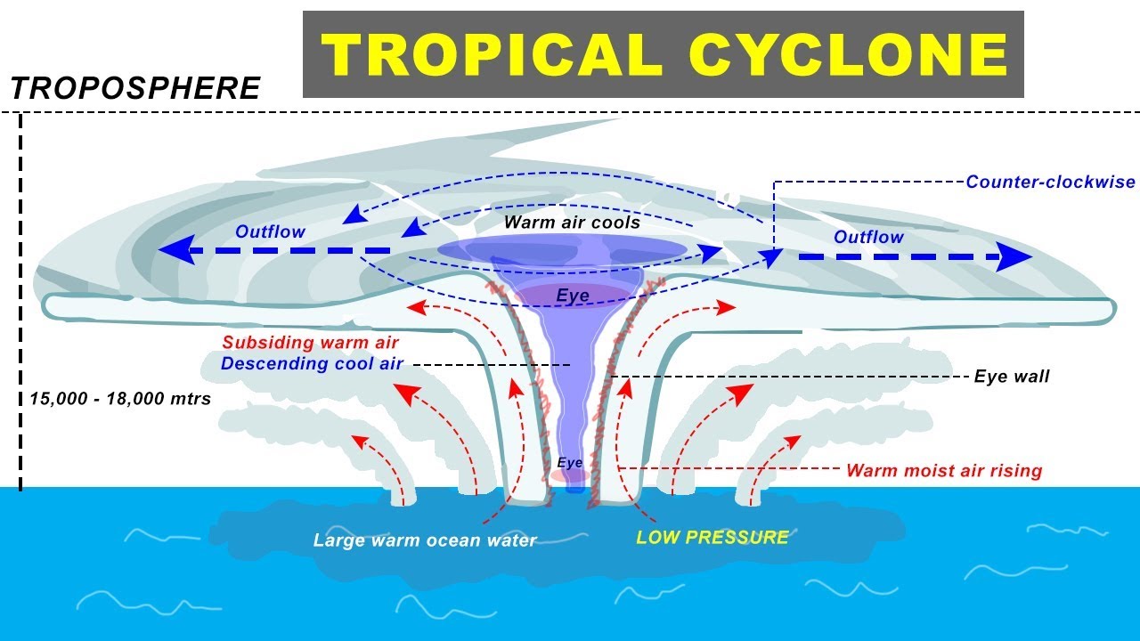
a region are prer bels we know that the trade winds which blow from the Eastern direction that is why they are called Easter when they reach the equator they will rise up and then this flow will again continue so it forms a Headly cell now here because the air is rising up there is low pressure region the low pressure in the low pressure region the air rises up it carries the moisture upwards th forming clouds and giving rainfall along this region so we will see that there are evergreen forest in this region throughout this equatorial
region we see that there are rain forests however if you go through the tropical or extratropical region we will see that there is another cell that is the feral cell and here we will see that there is a high pressure belt over here because the air is descending in this region now descending air it gets atically heated it does not have any moisture it does not bring rainfall so this region where we have this high pressure Bel there we see that there are deserts so the low pressure belt over here and the high pressure belt
over here determines the type of climate that the region will have jet stream is another important factor which affects climate of a region now jet streams do not actually affect the climate of a region but they more of affect the weather of that region but because of the increase in these incidents where there is either stoppage of jet stream or there there is expansion of jet stream we can see that it can alter the climate of that region that is why we are discussing the effects of jet stream on the climate so here we can
see that the jet stream it continuously rotates around the earth with these meanders there are Alternative High Press and low press regions so because the jet streams keep on rotating these regions also vary but sometimes it cannot happen that this rotation and stop when this rotation stops and a region is facing a high pressure region here there will be clear skies and because of this clear skies it will receive large amount of heat in this region and therefore the temperatures will increase and this is what is called Heat Wave there is an overall increase in
the number of instances of heat waves reported across the world now in Reverse to this there may occur that a region may have continuous low pressure region over there so this region which is continuously facing the low pressure region over it because of the slow movement of the jet stream it will experience rainfall or cloudy weather for a period generally The Vortex is confined to the polar region so the cold winds are confined in this region but sometimes the J can expand and they can bring the cold weather towards the American region or the Central
American region and this can decrease the temperature in this region so this is how the jet stream affect the climate of a region first is the movement or the circulation of the jet stream it becom slow so the region which has a high pressure region it will get heated it will experience Heat Wave second is by this expansion of polar vortex due to expansion of the jet stream another important factor which affects climate of a region is the physical relief or Geographic structure of that land so it can bring rainfall to that region by lifting
the air that is orographic rainfall or it can modify the wind patterns so here in our India we know and on the co we have the winds winds have to rise up to cross them and during this process we see that lot of rain for lockers because the rising air is adiabatically cool down and the moisture it becomes clouds and gives lot of rainfall in this region now here we can see two cities Mumbai and Pune and if you compare the rainfall in these two regions we can see the stack difference pun is while the
Mumbai is on the Windber side while Pune is on the leard side can see much less compared to mumb because the winds which come from that side that rise over the Western GS and because they are trying to rise over the Western GS they give lot of rainfall on that side of the mountain the slope of a region also affects the climate of that region suppose the sun which is giving sunlights to two regions here we have these mountains and because this mountains are horizontal or parall to the latitudes then the slope of this mountain
which is facing the sun it will receive large sunlight compared to the other side of the mountain which is not facing the sun there it will be much cooler and damp atmosphere compared to the side which is facing the Sun so the steep slopes have more rapid change in temperature than gentle slopes this is also effect of slopes that if the steeper the slope is there there will more fast changing temperature slopes facing Sun receive more sunlight while that temperature is higher so the side which is facing the sun will have higher sunlight so it
will have higher temperature and slopes on the windward side of mountain receive more rainfall so if a slope is facing the windward side that is winds are coming from the oans towards it then that side will receive more rainfall just like our Western guards where Mumbai is on the windward side so Mumbai receives more rainfall compared to Pune where Pune is on the lever side ocean currents also play a very important role in determining climate of a region so here we can see a map of ocean currents this yellow color indicates warm oan currents while
this blue color indicates cold water currents so if you see these regions where the warm water currents are flowing these are the Eastern margin of the continents in the tropical region the winds which will flow from this o towards here it will give lot of rainfall to the adjoining region the reason is that the warm currents will have moisture along with it and this moisture will be taken away by the winds towards the land causing rainfall while if you see the Western margin of the continent we will see that there are cold water currents these
cold ocean currents they will actually cool down the moisture in the air which we can see here so Forks are formed on this region that is on the oceans that is adjoining the continent so all the moisture in the air is removed by the fog which is formed because of this cold atmosphere created by this ocean current so when this air reaches the coastal region it will not have any moisture so it will not be able to give rainfall to these regions and therefore we see that on the western margin of continents we have deserts
Kalahari Desert Sahara Desert move desert atakama desert and we have West Australian desert now if you go to the higher latitudes we will see that on the western margin of continents we have warm currents we considered Gul stream it drinks warm Waters from the tropical regions in this region when here we have cold current that drinks cold water from the polar regions and here we have taken two cities lyen and Halifax both are almost on the same latitude but if you see that temperature we can clearly see that Halifax which is located in Canada its
temperature goes below 0° C for 4 months in a year while for the same latitude London it does not pass 0 de line almost equal 23 23 so because of this warm current which comes to this London or this regon it warms up the atmosphere and it also does not allow snow forming in this region on the sea Source therefore the ports are open in this region uping regions are also created so basically there are regions where there is this cold water current and warm water current meet and they produce a very foggy kind of
atmosphere this is also a way in which the ocean currents will affect climate of a region then we come to the soil the soil of a region also affects the climate of that region and the soils are light in color they will reflect more light so this light is sent back to the space it is not absorbed by the land while if the soil is darker in the col it will absorb more radiation and therefore there will be more heating of this region so a region having dark colored soil will be heated more compared to
the region having white colored or light colored soil now the climate of a region is also affected based on whether there is dry soil or moist soils in that region the dry soil like in our T desert it can easily change its temperature there can be large variations in day and night temperature it can easily absorb heat and it can very quickly release itat but compared to that the moist soils they heat up slowly the temperature increases much slower compared to the dry soil and they also lose temperature very slowly so the temperature variation is
lesser in the moist soil regions while in the regions where there's dry soil like the deserts there is much higher temperature variation the last important factor which affects the climate of a region is the vegetation trees that block the sunlight from reaching the ground therefore the solar radiation which is coming from the sun does not reach the Earth and it does not heat the Earth it is reflected backward towards the space and second the trees also give out water vapor during the photosynthesis process and because of this there is increase in moisture in that region
and there there is increase in the amount of rainfor in that region so the vegetation also affects in the climate of a region I hope we have covered all the important factors if there are some factors we have left out do let us know in the comments if if you have any doubt in the video then you can ask in the comments if you like this video then do subscribe to the channel and share with your friends and if you like what we are doing then you can use the UPI code support us but