Iceland, where fire and ice coexist. Despite being a small country, it's filled with astonishing natural wonders. Here, nature reigns over man.
The intense volcanic activity has crafted a unique terrain. Landscapes seem from distant planets. In this documentary, we'll explore Iceland's most amazing places.
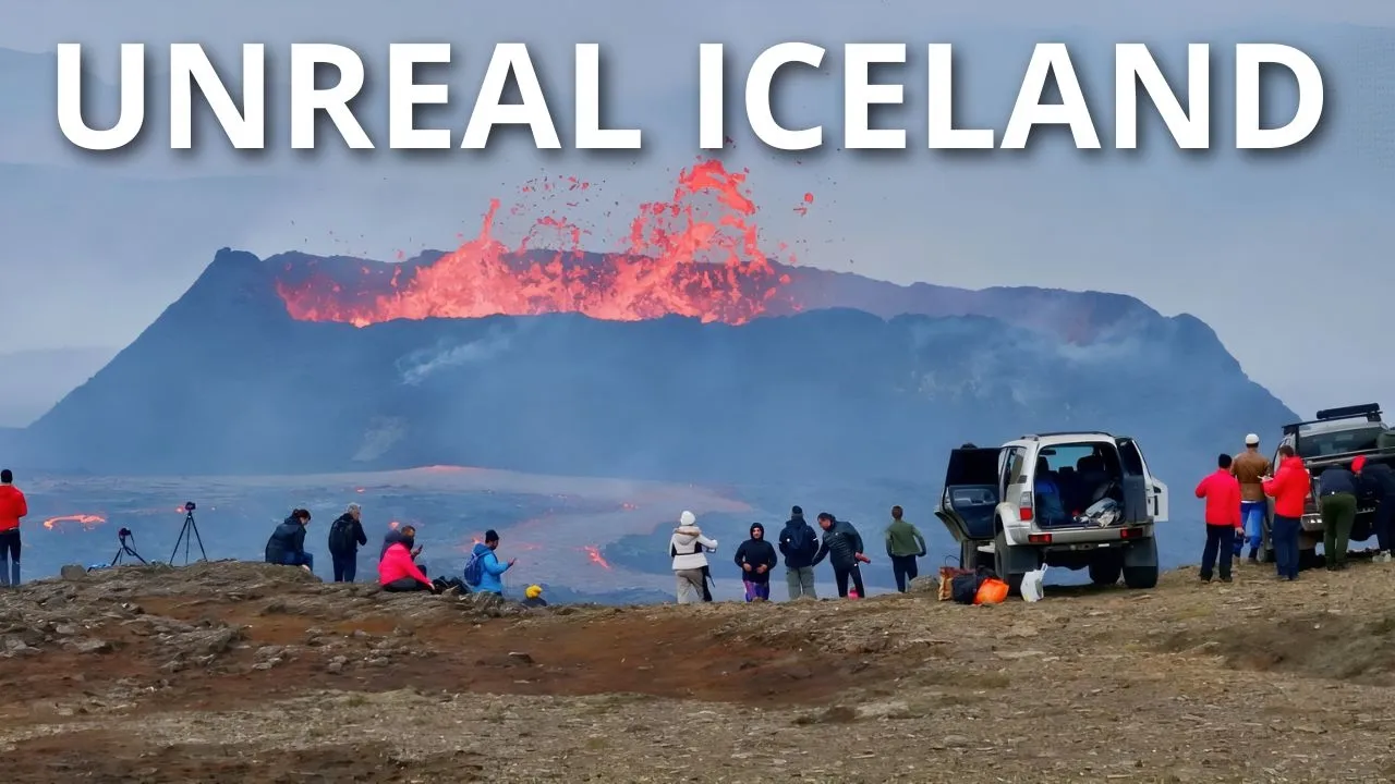
A journey to the most remote and hidden enclaves on Earth. Fagradalsfjall It's a volcanic system located in the Reykjanes Peninsula, in the country's southwest. But it's not just one volcano, rather a collection of several cones and fissures.
It lies in a tectonically active area, where the Eurasian and North American plates diverge. Its formation began during the last glacial period, indicating it emerged under a layer of ice. Initially, the lava erupting from a volcano is bright red and exceeds 1000 degrees Celsius or 1800 degrees Fahrenheit.
As the lava flows and comes into contact with air, it cools quickly, forming a solid crust. Accessibility from Reykjavik has turned Fagradalsfjall into a site frequently visited by the curious. During eruptions, spectacular rivers of fire and formations of fresh lava are created.
However, after an eruption, the levels of volcanic gasses are dangerous. After a while, it seems safe, but there might be burning lava beneath a thin layer. Litli-Hrutur This volcano is part of the Fagradalsfjall system.
When Litli-Hrutur erupts, lava bursts through ground fissures. Instead of a violent explosion, the magma flows smoothly, creating lava streams. A line of fire is visible, with lava emerging from a linear crack.
Pieces of cooled lava accumulate around the fissures. Over time, volcanic materials rise and form a volcanic cone. Gradually, a more stable structure forms, with a central crater acting as the main lava exit point.
During the eruption, the flows extend, leading to vast lava fields. Geysir Geothermal Area Considered one of the most spectacular geothermal fields in the world. The Haukadalur valley, where it is located, is a highly active geothermal area.
It's filled with hot springs, mud pits, and geysers, with a surface marked by vibrant colors. The great Geysir has had periods of activity and inactivity over the years. Earthquakes often reactivate it, though its activity decreases again as years pass.
In contrast, the geyser Strokkur erupts every few minutes, shooting huge columns of hot water. In geothermal areas like this, hot magma is close to the surface, heating the rocks. Water heats up, increasing pressure in the geyser's conduit.
Upon reaching an unsustainable pressure level, hot water and steam are expelled forcefully. Thingvellir National Park A site of historical and geological significance. This is where Icelandic democracy originated, with the establishment of the first parliament in 930.
But what's truly captivating is its location at the point where the North American and Eurasian tectonic plates slowly drift apart. In Thingvellir, this process occurs on land, allowing for direct observation. The tension and movement between the plates has created numerous fissures.
The most astonishing is Silfra, a channel filled with meltwater from the nearby Langjökull glacier. The water is so clear because it has been filtered for decades through lava fields. This clarity earns it a rank among the world’s best spots for cold-water diving.
Visibility is so good that divers feel like they are flying over an abyss. One might say they are swimming between two continents. Vatnajokull In terms of area, it's the largest glacier in Europe.
A vast ice cap covering about 8 percent of Iceland’s territory. Its icy mantle spreads over mountains, valleys, and even reaches the ocean at some points. It has multiple glacier tongues that extend from its central mass to the valleys and lowlands below.
In areas where the ice is thicker, a bluish hue appears. Fissures open perpendicular to the glacier's flow, like a natural artwork. To geographers, these are known as "crevasses".
They have formed due to stresses and compressions in the glacial ice. In each area of Vatnajökull, the crevasses look distinct. They are more visible during the warmer months, when the glacier’s surface melts.
This leads to meltwater rivers and streams. They can carve intricate paths through the landscape, creating mesmerizing patterns. The water’s celestial hue is caused by the fine particles of glacial flour that remain in suspension.
Jokulsarlon Glacier Lagoon Relatively young, this body of water began forming about a century ago due to the retreat of the Breidamerkurjökull glacier, an extension of Vatnajökull. It contains numerous detached icebergs that float around the lake. They vary in shape, size, and color.
Some display an intense blue color, a result of ice compression over hundreds or even thousands of years. Others appear white, indicating they contain air bubbles in the ice. Additionally, Jökulsárlón is a prime spot for seal spotting, especially in winter.
It is said to be a paradise for them, as there are no predators like orcas or sharks. The lake is connected to the Atlantic Ocean via a short river. Icebergs slowly drift through it.
Later, the waves carry some to the shore. This is called the diamond beach. The black sand contrasts with the ice fragments, resembling precious stones.
Studlagil Canyon The construction of a dam in 2009 reduced the flow of the Jökulsá á Dal river, revealing this gorge. Its walls are made up of basalt pillars. These appeared due to the slow contraction of lava as it cooled, creating geometric patterns.
The river runs through the canyon, acquiring a beautiful turquoise color in summer. The red coloring seen in certain rocks is caused by iron oxides. Northern Lights Iceland's proximity to the Arctic Circle enables the observation of this fascinating natural phenomena.
They are most visible away from the light pollution of urban areas. These occur when electrons and protons from the solar wind reach Earth. The weaker terrestrial magnetic field at the poles allows some particles to enter the atmosphere.
Upon colliding with atmospheric gasses, these charged solar particles cause atoms to emit light. The most common color, a bright green, is produced by oxygen molecules. Sometimes red hues appear, when solar particles react with oxygen at high altitudes.
Ice Caves These are natural formations located within glaciers like Vatnajökull and Langjökull. They develop from water flowing through the glacier or from geothermal heat melting the ice. Tunnels with beautifully sculpted ice walls are created.
The ceiling, with its translucent surface, casts a luminous glow. The denser ice, compressed over the years, exhibits an intense blue. In warmer months, water begins to flow.
It seeps through cracks and fissures in the ice, forming streams that run inside the cave. Vestmannaeyjar Also called the Westman Islands, this archipelago lies off the southern Iceland, isolated in the waters of the North Atlantic. It consists of a main island, Heimaey, and 15 small uninhabited islands.
Geologically, the youngest islands are also the smallest, created by underwater volcanic activity. Bjarnarey, the island closest to Heimaey, has historically been a hunting ground for puffins. The lone house visible is a refuge for hunters.
Ellidaey is slightly more distant and flatter. Its only structure is a hunting lodge built in the 1950s. Heimaey is the largest and only inhabited island of the Westman Islands, formed by multiple volcanic eruptions that occurred between 10 and 12 thousand years ago.
It's a small community with a quiet lifestyle, particularly dedicated to fishing and tourism. In the eastern sector is located the volcano Eldfell, which erupted in 1973. The volcanic explosion covered one-third of Heimaey with lava and ash.
Lava flows added new land, expanding the territory of the island. Most of its coast is outlined by steep cliffs of volcanic rock. The ocean has sculpted numerous natural arches.
Elephant Rock stands out, naturally carved by the force of the waves. Hverir Located at the base of Krafla volcano, this geothermal region is influenced by an underground magma chamber. It resembles another world, with its vast plains of red and orange earth, interspersed with mud pots and white smoke.
The soil's colors are due to the high concentration of minerals. The area is filled with fumaroles, emitting steam and gasses at high temperatures. The heat from the magma warms the groundwater, which rises as steam through fractures and pores in the rock.
Mud pots are another visual attraction at Hverir. They form when steam rises through deposits of clay and soil. Despite its beauty, the area can be dangerous due to gas emissions, so it is necessary to stick to the tourist walkways.
Reynisfjara Known for its black sands which are composed of heavily eroded volcanic rocks. The lava cooled when it touched the ocean and broke down into small fragments. The landscape is complemented by huge basalt columns.
The lava from multiple eruptions solidified, contracting and fracturing into geometric shapes. As winter approaches, Reynisfjara undergoes drastic changes. The waves of the North Atlantic reach the shore with a penetrating cold.
The sand, partially covered by snow and ice, creates a stunning visual contrast. Off the coast rise the Reynisdrangar, rock pillars that emerge from the sea. According to local legend, they are trolls that tried to drag ships ashore.
But they were caught by the first light of dawn and turned to stone. Visitors must be aware that the waves at this beach are strong and treacherous. They sometimes appear suddenly and can drag people into the sea.
Skogafoss This waterfall is distinguished by its wide water drop that plunges into a deep pond. It is bounded by cliffs that once formed the Icelandic coast. It maintains a powerful flow all year round, with water coming from the Eyjafjallajökull glacier.
Legend has it that the area's first Viking settler buried treasure in a cave behind the waterfall. Locals discovered the chest years later, but only managed to touch it before it vanished. Reykjadalur Hot Springs Dubbed the world's hot spring capital, this is a geothermal area near the town of Hveragerdi.
Hot springs, mud pots, and steam vents abound, creating a misty landscape. A warm river runs through the valley, forming natural pools. Each has a different temperature, allowing bathers to choose their preferred warmth.
Due to the geothermal activity, the area is characterized by a strong sulfur smell, typical in volcanic areas. Fjadrargljufur Canyon It's a breathtaking gorge located in the southern part of the country. A masterpiece of nature with its meandering rocky formations.
Fjadrárgljúfur is believed to have been formed during the last Ice Age, over nine thousand years ago. The Fjadrá river runs along the bottom of the gorge, zigzagging its way. The moss thriving on nearby rocks gives them a green appearance.
This vegetation is capable of surviving in extreme conditions, typically growing in volcanic areas. Eyjafjallajokull Considered one of the country's smallest glaciers. The area is highly seismic, with frequent earthquakes preceding volcanic eruptions.
Hidden beneath the ice cap of Eyjafjallajökull lies the caldera of a volcano. The eruption that began in 2010, though small by volcanic standards, caused significant disruption across the region. The interaction between the hot magma and ice created a massive cloud of volcanic ash, leading to the cancellation of tens of thousands of flights across Europe.
Thrihnukagigur It is a dormant volcano, one of the few in the world whose interior can be explored. It hasn't erupted in about four thousand years. Most volcanoes seal their magma chambers with solidified lava after an eruption.
However, when this volcano last erupted, the lava drained into the ground, leaving a large empty space. Surtsey Among the Vestman Islands, this geological wonder stands out as the southernmost point of Iceland. It emerged from an underwater eruption that began in 1963 and continued until 1967.
It was one of the most significant geological milestones of the 20th century, giving scientists the chance to study the creation of a new island. Serving as natural laboratory without human intervention, it reveals information about geological and biological processes. It is currently inhabited by numerous plants and birds, along with hundreds of species of invertebrates.
Laki Fissure It emerged as a volcanic fissure due to the devastating eruptions that occurred between 1783 and 1784. It released such a massive volume of lava that it ranks among the largest documented volcanic eruptions. The volcanic gases poisoned the pastures, killing much of the livestock and causing a famine that wiped out 25% of the Icelandic population.
The eruption had a significant impact on the global climate, causing a drop in global temperatures. The toxic fogs that spread across Europe deteriorated air quality, causing thousands of deaths from respiratory diseases. According to some historians, the poor harvests caused by the eruption helped stoke the social discontent that culminated in the French Revolution.
Eldhraun Beneath a thick blanket of moss lies a vast lava field. The result of the Laki eruption. Lava spread across the terrain, covering valleys and fields.
Over time, the molten lava hardened, creating a rough and rugged surface. Initially, the environment was devoid of life, but gradually it began to be colonized by mosses and lichens. The moss, in particular, adapted to the cooled basaltic rocks, establishing and expanding its presence.
Seljalandsfoss These waterfalls cascade over a cliff that was once part of the coastline. A reflection of how tectonic movements have altered the Icelandic landscape over time. It belongs to the Seljalandsá river, whose source is the Eyjafjallajökull glacier.
It features a unique geological structure, with a cavity behind the waterfall. This makes it one of a few waterfalls in the world where it's possible to walk behind. Landmannalaugar Its name, meaning "the people's hot springs," comes from its centuries-old use as a bathing spot.
It's a popular destination among hiking enthusiasts and those seeking to bathe in natural hot springs. Located in a valley between mountains and endless lava fields. The mountains display an incredible variety of colors, including bluish-green hues.
This is due to the minerals present in rhyolite, a rock formed when silica-rich lava cools rapidly. The black lava field of Laugahraun, resulting from a 1477 eruption, lies among the mountains. It covers a large area, with the solidified lava forming complex shapes.
To the north lies Frostastadavatn lake, formed from volcanic eruptions. Lava flowed across the land, creating natural barriers that trapped the water. Near this area is Bláhylur, a volcanic crater lake.
It formed within the crater left by a powerful volcanic explosion. Kerlingarfjoll It's a mountain range known for its rhyolite peaks and extensive geothermal areas. The mountains are painted in vivid hues of oranges, reds, and yellows, due to the high presence of volcanic minerals.
Kerlingarfjöll is part of a volcanic network with a large central caldera, with the landscape shaped by magmatic activity. Various geothermal phenomena are observed in the area. Water emerges at the surface as springs, heated by the proximity of magma.
In the mud pots, boiling and bubbling mud can be seen. Thorsmork A nature reserve located between the Tindfjallajökull, Mýrdalsjökull, and Eyjafjallajökull glaciers. It comprises a zone of protected valleys, flanked by mountains and vast glaciers.
The name Thórsmörk literally translates to "Thor's forest," in honor of the Norse god of thunder. Unlike much of Iceland, this area has lush vegetation, rich in mosses and wildflowers. Various rivers flow through the valleys, originating from the nearby glaciers.
Their flow varies with the seasons and weather conditions. During periods of thaw, they swell rapidly, and crossing becomes a challenge. In 2010, Thorsmork was affected by the eruption of nearby Eyjafjallajökull, but the area has since recovered.
Blue Lagoon It's a geothermal spa located in a lava field. Its waters are a milky blue, surrounded by black volcanic rock. They contain high levels of silica and sulfur, which give it this appearance.
The water temperature remains warm throughout the year. In the colder months, the steam intensifies the ethereal atmosphere. Despite its natural appearance, this lagoon was created in 1976 as a byproduct of the Svartsengi geothermal plant.
Dettifoss It is characterized by its impressive width and the large volume of water that descends in a powerful and noisy fall. It is one of the most powerful waterfalls in Europe measured by the sheer volume of water. The amount of energy released is so great that one can feel the ground tremble underfoot when approaching the edge.
The water of the Jökulsá á Fjöllum river, which feeds the waterfall, carries glacial sediments that give the water a brown color. Dettifoss was featured in the science fiction movie "Prometheus," directed by Ridley Scott, which increased its number of visitors. Borgarfjardarhofn This small remote village in the northeast of the country, Borgarfjördur Eystri, is one of the best places in the world for bird watching.
Here lies Borgarfjardarhöfn, a reserve for Atlantic puffins. Facilities were built to minimize human disturbance in the natural habitat of this curious species. Puffins are seabirds that only come to land to reproduce and nest.
They arrive at the coast in April and by the end of August return to the sea, where they stay the rest of the year. They nest in colonies on cliffs or islands, digging tunnels to lay a single egg. They are usually monogamous, returning with the same partner each breeding season.
Excellent in flight, they flap their wings hundreds of times per minute. They are also notable swimmers, using their wings to chase fish underwater. Skutustadagigar In the Mývatn lake area in northern Iceland, this series of pseudocraters stands.
It's a very rare geological phenomenon worldwide. After an eruption, the hot lava came into contact with water, quickly turning it into steam. The rapid transformation from liquid to gas caused explosions, leaving holes in the ground and accumulations of volcanic material.
Kerid Crater At the bottom of this volcanic crater, there is a lake, whose walls are stained with rusty red and brown. At only six thousand five hundred years old, it is young compared to other geological formations in the area. It is thought to have been a conical volcano whose eruption caused the collapse of its cone.
Unlike other craters filled with rainwater, it is believed that Kerid's lake is fed by groundwater. Gullfoss In summer, the abundant flow of this waterfall creates a marvelous scene. It is said that Gýgur, who owned a large amount of gold, threw a chest into its depths, which earned it the name of the golden waterfall.
Located in the Hvítá river canyon, it features two main waterfalls. Over millennia, the flow of the water shaped the rock, creating the crevice seen today. Snaefellsjokull National Park It's one of the country's most iconic national parks.
Named after the Snaefellsjökull volcano, which features a glacier visible from Reykjavík. Jules Verne's novel "Journey to the Center of the Earth" was based on this stratovolcano as the gateway to the underground world. The park showcases a diversity of geological formations, such as lava tubes and volcanic craters.
Nearby is Arnarstapi, a small village with striking rocky outcrops. These hexagonal basalt columns arose from the cooling of a thick lava flow. Also notable is Gatklettur, a natural arch sculpted by the force of the waves against the volcanic rock.
Kirkjufell Located on the Snaefellsnes Peninsula, this mountain has an unusual conical shape. It rises alone from sea level, independent of other mountains. Volcanic eruptions followed by glacial erosion gave rise to its peculiar appearance.
In summer, Kirkjufell turns intensely green, covered with grass and moss. Kirkjufellsfoss, the nearby waterfall, seems to spring directly from the mountain. It is fed by the Kirkjufellsá river, which originates in the nearby mountains and flows to the sea.
Grimsey Island To the north of Iceland's north coast, within the Arctic Circle, lies this small island. Due to this position, for much of the summer there are 24 hours of light, while in winter almost the entire day remains in darkness. Unlike mainland Iceland, full of mountains and volcanoes, Grímsey's terrain is flat.
Only a few dozen people live on the island, though there are thousands of birds. Amid this isolation stands a notable mobile monument: a large stone sphere that marks the position of the Arctic Circle. Thridrangaviti Lighthouse A solitary guardian in the vast blue of the North Atlantic, south of Iceland.
This sanctuary of peace is accessible by sea, though helicopter is another viable option. The construction of the lighthouse in 1939 was a remarkable feat, considering the complex geography of the location. Godafoss In winter, these falls transform into a frozen paradise, with elaborate ice formations.
It is one of Iceland's most spectacular and historically significant waterfalls, known as the waterfall of the gods. It is part of the Skjálfandafljót river, flowing from the central highlands, an uninhabitable area formed by basalt mountains and lava fields. Legend has it that in the year 1000, when Iceland converted to Christianity, statues of Norse gods were thrown into the waterfall.
Krafla It's a volcanic caldera located near Lake Mývatn. Defined by fissures that cut through a central volcano, forming a volcanic system. In the crater of one of the eruptions, the Víti lake emerged, whose turquoise waters stand out against the rocky and red surroundings.
The Krafla geothermal power station utilizes the energy from the subsurface, one of the first of its kind in the world. It employs turbines driven by the steam of hot water obtained from the ground. Hengifoss The area surrounding these waterfalls has experienced volcanic eruptions for millennia.
The striking red lines visible on the cliff wall are layers of clay originating from volcanic ash. During eruptions, the ash was deposited on the ground, compacting into clay. When the iron minerals in the clay were exposed to oxygen, they oxidized, giving it a red hue.
Over thousands of years, lava from new eruptions covered the layers of reddish clay, explaining the dark layers. This alternation between dark and red layers illustrates the various geological ages. Sigoldugljufur This is a spectacular canyon nicknamed the "Valley of Tears”.
Defined by steep walls and a series of waterfalls cascading into the deep valley below. The force of water and earthquakes gradually wear down the rocky walls. The river flowing through the canyon, coming from nearby reservoirs and meltwater, feeds the numerous waterfalls.
Hafragilsfoss A powerful natural wonder within Vatnajökull National Park. It is one of the waterfalls of the Jökulsá á Fjöllum river, downstream from the famous Dettifoss. It falls into the Jökulsárgljúfur canyon, formed by volcanic activity and glacial floods.
The torrential river has carved the bedrock for more than two thousand years. After Hafragilsfoss, the water continues its course and reaches a glacial spring, resulting in what is known as a water encounter. The clear turquoise water is typical of waters coming from glaciers.
When it merges with the river, which carries murkier water, abstract patterns are created at the meeting point. Katla Volcano Considered one of the most active and powerful volcanoes in Europe. Its crater remains hidden, covered by the Mýrdalsjökull glacier.
Katla is named after a malevolent witch in Norse mythology, who, when pursued by her enemies, threw herself into the volcano. Over the past 20 years, it has experienced numerous major eruptions. They are particularly explosive and dangerous.
Given its activity, Icelandic volcanologists constantly monitor it using seismographs. Within the Katla volcanic system lies Eldgjá, the largest volcanic canyon in the world. The eruption that occurred here in 939 was one of the largest lava floods of all time.
Gljufrabui Hidden behind a cliff, this waterfall is more difficult to reach. Its name, meaning "Dweller of the gorge," refers to its hidden location in a narrow canyon. Because it is behind a large cliff, its visibility from a distance is less than that of other waterfalls.
Visitors can access the base, an enclosed space with moss-covered walls. Hraunfossar The meltwater from the Langjökull glacier seeps through porous volcanic rock to reach this spot. Known as "lava waterfalls," it is a series of cascades that spring from a small cliff.
After the colonization of Iceland, a volcanic eruption created the lava field through which the water flows. Legend has it that a sorcerer diverted the Hvitá river, creating the waterfalls. Mulagljufur Canyon Also known as Múlafoss, this deep and narrow gorge features vertical walls of volcanic rock.
Access is challenging, especially during the winter months. A river runs along the canyon floor, fed by meltwater from nearby glaciers and rainfall. The topography, with its steep slopes and rocky cliffs, gives rise to tall waterfalls.
Foss a Sidu A hidden gem, this waterfall is near the village of Kirkjubaejarklaustur. It falls dramatically from a cliff partially covered in vegetation. It incorporates a historic farm that has been operational continuously since the Viking settlement era.
Indeed, this area is mentioned in one of the earliest works of Icelandic literature, the Book of Settlements. Maelifell It's a volcano in the Highlands, starkly visible against a desert of black sand. Accessible only by 4x4 vehicles and only in summer, it is in one of Iceland's most remote regions.
It has an almost perfect conical shape, composed of layers of hardened lava. It was once covered by the Mýrdalsjökull glacier, emerging about 10,000 years ago at the end of the last Ice Age. Glacial rivers surround it, forming branches as they flow.
Dyrholaey Lighthouse Located at the highest point in the area, it offers a stunning panoramic view of the Atlantic Ocean. It was built in 1927 to assist ships approaching the southern coast. These cliffs are primarily composed of black basalt, the most common magmatic rock in the country.
It consists of an area rich in geological formations, like the Dyrhólaey arch. Formed over millennia from volcanic eruptions, it has been sculpted by the waves. The area around the lighthouse is ideal for bird watching, especially for puffins that nest on the cliffs.
Westfjords It's a large peninsula filled with mountains, cliffs, and fjords. With few inhabitants, this area is one of the most remote in Iceland. It features multiple deep bays that cut into the land.
And some mountains formed millions of years ago. The Látrabjarg cliffs are among the tallest in Europe. It's a breeding ground for Atlantic puffins.
Many of the roads in the Westfjords are narrow and traverse the steep mountain slopes. One of them leads to Raudisandur beach, which translates to "red sand. " But it is not a single shade of red.
It varies between red, pink, gold, and white. The presence of mollusk shells and other marine organisms in its composition is the reason for its appearance. Another natural phenomenon of this peninsula is the Dynjandi waterfall.
It resembles a bridal veil, cascading in steps. The upper level is the widest, spreading across the mountain. Ljotipollur Despite its beautiful appearance, its name in Icelandic translates to "ugly puddle.
" It is a crater lake formed in 1477 by an explosive eruption. The blue of the lake's water enhances the color of the red walls. Additionally, green lines of mosses and lichens have grown on the volcanic terrain.
Vestrahorn and Stokksnes Beach Vestrahorn is a majestic mountain, considered one of the most iconic in Iceland. It features sharp peaks and jagged ridges that extend towards the sky. It is made of gabbro and granite, which gives it a dark color.
Stokksnes, which borders Vestrahorn, is equally stunning. It consists of a black sand beach with unusual green mounds. These are plants adapted to sandy environments that grow in the dunes.
Eystrahorn It is a long mountain near Vestrahorn. Not easily accessible, it offers a more solitary experience. It rises directly from the sea, surrounded by waters.
Its slopes are often covered with snow in the colder months. Like many other parts of the country, Eystrahorn experiences rapid weather changes that alter the landscape within minutes. Nauthusagil A waterfall located in a remote and difficult-to-access place.
It falls at the end of a canyon, and reaching it requires being well-equipped. To get there, one must pass through narrow passages. At the end, a hidden small pool that receives water from the stream is revealed.
Hverfjall Almost perfectly circular, it is one of the largest tuff rings in the world. It is part of the highly geothermal and lava field-surrounded Krafla volcanic system. It was created from an explosive eruption about two thousand five hundred years ago, which is quite recent in geological terms.
Due to the acidity of the soil and its volcanic origin, it is devoid of vegetation. Husavik A coastal town in the north, set against a backdrop of mountains and blue waters. According to the Icelandic sagas, it was one of the first Viking settlements on the island.
It is known as the "whale watching capital" due to the diversity of cetacean species sighted in Skjálfandi Bay. It is possible to see humpback whales, fin whales, and minke whales, among other species. During the 19th and early 20th centuries, whale hunting was crucial to Húsavík's economy and much of the nation.
However, the town evolved into a center for cetacean observation. Asbyrgi A massive flood during the last glacial period created this horseshoe-shaped canyon. It is a small geological wonder of Vatnajökull National Park.
According to local folklore, Sleipnir, the horse of the Norse god Odin, left the imprint of one of his hooves. This environment hosts a lush forest of birch and willow trees, unusual in the Icelandic landscape. Bjarnafoss It stands out for its height and the powerful waterfall cascading from a rock cliff.
Local legends claim that mythical beings live in nearby caves. As it falls, the water passes over basalt formations that line up in hexagonal columns along the cliff. Solheimasandur Plane Wreck These are the remains of a Douglas DC3 from the United States Navy.
It ran out of fuel while flying over the area on November 21, 1973, and crashed on the Sólheimasandur beach. After the accident, the cost of recovering it was deemed too high, and it was left abandoned. What remains is the fuselage, parts of the wings, and the tail section, all resting on a desolate surface of volcanic sand.
Reykjavik It is the capital closest to the North Pole. It was the site of the island's first permanent settlement, established by the Viking explorer Ingólfr Arnarson in 874. It is reputed to be one of the cleanest, greenest, and safest cities on the planet.
Underlying volcanic activity allows for the generation of electricity. Due to its location, it experiences illuminated nights from May to August and few hours of light from December to February. Buildings like the Hallgrímskirkja church stand out, whose design is inspired by lava columns.
Started in 1945, its completion took more than 40 years. Isafjordur It serves as the administrative center of the Westfjords. Its natural setting is splendid, with towering mountains, and the fjord opening out to the Greenland Sea.
It was once one of the country's largest fishing ports, with a trading history dating back to the 16th century. Some of the town's oldest buildings are made of wood, painted in bright colors, in a style unique to this region. Seydisfjordur This settlement was colonized in 1848 by Norwegian fishermen.
In 1906, the first telegraphic cable linking Iceland to Europe was installed here. It remains a fishing village, but the economy has been developing towards tourism. Although located in the northeast, it has a tundra climate with high humidity.
Lupine Fields They have become a true natural spectacle in summer. Introduced in the 20th century, they have since thrived, covering vast areas of the country. They were introduced to combat deforestation and improve soil fertility.
By densely covering the ground, they support the growth of native plants and the survival of local animals. When in bloom, they transform into a colorful carpet that sometimes surrounds other natural wonders. Eldborg It is an oval-shaped volcanic crater, with steep sides and a defined rim.
In Icelandic, "Eldborg" means "fire fortress," alluding to its fortification-like shape and volcanic origin. It developed from a fissure eruption, with lava erupting from a crack in the ground about 5,000 to 8,000 years ago. The ease of access and views from the top make the hike to the crater very popular with tourists and locals.
Akureyri Sometimes called the capital of the north, it is located very close to the Arctic Circle. Helgi magri Eyvindarson, a Norwegian Viking, was the first to settle in the area. The city is situated at the base of the Eyjafjördur fjord, surrounded by snow-capped mountains well into spring.
The architecture blends traditional and modern styles, with colorful wooden houses alongside contemporary buildings. Despite its location, Akureyri enjoys a relatively mild climate thanks to warm ocean currents. Hornstrandir It is the most remote area of the Westfjords.
Only accessible by boat or on foot from the south, it is uninhabited. Its ecosystems remain largely intact, as it is one of the country's most protected natural areas. This isolation makes it one of the best places in the world to observe the Arctic fox in its natural habitat.
In summer, their fur darkens, helping them to camouflage in the tundra. Siglufjordur It is a small fishing village nestled in a fjord on the Tröllaskagi peninsula. Surrounded by steep mountains and the North Atlantic Ocean, with traditional houses and a small harbor.
Once known as the "Atlantic herring capital. " Before the construction of tunnels, it was one of the most isolated settlements in the country, accessible only by sea or mountainous paths. Grjotagja Cave Hidden in this small cave is an underground thermal spring.
The water is an intense blue, and light filters in softly, creating a mystical atmosphere. Until the 1970s, locals frequently came here to bathe. However, seismic activity raised the water temperature, making it too hot for safe bathing.
Myvatn Nature Baths These are large pools of milky blue thermal waters, surrounded by volcanic landscapes. The water is naturally heated by an underground geothermal source. It is believed that their high concentration of silica and minerals is beneficial for the skin.
While other natural baths are more touristic, these are also frequented by Icelanders. Grabrok Crater Considered an extinct volcano, it is part of a volcanic system that contains three craters. It was created by a volcanic eruption about three thousand years ago.
It has the typical conical shape of a volcanic crater, with walls composed of rocks from ancient eruptions. Bruararfoss It consists of a series of small waterfalls that flow over a lava field. The glacial river Bruara makes its way through a deep crevice cutting through the center of dark volcanic rock formations.
This results in rapids of celestial blue, a product of the mix of meltwater and mineral-rich spring water. Vik It is the southernmost village in Iceland, positioned on the coast of the Atlantic Ocean. A small, tranquil community with traditional Icelandic architecture.
It is under constant threat due to its proximity to the volcano Katla. The Atlantic Ocean stretches out in front with its black sand beaches, while tall mountains rise behind. Svartifoss Its name, meaning "black falls," is due to the dark basalt columns that surround it.
The base is covered with sharp rocks that have broken off during seismic activity. Its appearance has influenced Icelandic architecture, as seen in Reykjavík's Hallgrímskirkja church. Fjallsarlon At the foot of the Fjallsjökull glacier lies this lagoon, part of the vast Vatnajökull.
It is less known than its neighbor Jökulsárlón, but equally spectacular, with large ice masses. Along the lagoon, icebergs break off from the glacier. The water is a deep blue, and the icebergs, compressed over centuries, display various colors.
Kolgrafafjordur A fjord located on the Snaefellsnes peninsula. It was a fishing and trading post for the surrounding communities. It extends inland from the coast, with steep cliffs and mountains rising from the shore.
The waters are generally calm, reflecting the sky and surroundings. Solheimajokull It is a glacier situated between the volcanoes Katla and Eyjafjallajökull, part of the larger Mýrdalsjökull glacier. Notable for its enormous crevasses, some of which are suitable for climbing.
Appropriate equipment, such as crampons, harnesses, and ropes, along with technical skills for moving on ice, is required. Participants often rely on guides who are well acquainted with the geography and know how to conduct the activity safely. Although some glaciers are accessible year-round, the best conditions for climbing are usually in the summer.
Hrunalaug This small natural thermal pool is located near the village of Flúdir. It is believed that locals have used it for bathing for centuries. The underlying geothermal activity heats the waters, providing an authentic hot spring experience.
Aldeyjarfoss Fed by the Vatnajökull glacier, this waterfall plunges down the Skjálfandafljót river. Framed by black basalt columns, it shines with its white and foamy water. The contraction and gradual solidification of the lava have created geometric structures.
To reach it, a 4x4 vehicle is necessary, as it is located in a remote area. Hvitserkur It is a unique rock formation in Húnaflói Bay. A monolith of tuff surrounded by the North Sea.
Its appearance is reminiscent of a rhinoceros, an elephant, or a dragon drinking water. Legend has it that it is a troll petrified by the first rays of dawn as it attempted to destroy a nearby monastery. Secret Lagoon This geothermal pool is naturally heated.
It is the oldest pool in the country, opened in 1891. Its rustic appearance has been preserved over time to maintain its historical value. Eskifjordur A small town in the Eastern Fjords.
Nestled in the fjord of the same name, surrounded by rugged terrain and serene waters. Historically, it has been a vital port and fishing center for this region. It is characterized by its colorful houses against the backdrop of the mountains and the North Atlantic Ocean.
Haifoss One of the tallest waterfalls in Iceland, accompanied by its neighbor Granni, which means "neighbor. " They are somewhat isolated, in the valley of Fjórsárdalur, requiring a short hike to reach. Haifoss is surrounded by steep cliffs, and its water falls directly onto the rocky base.
Raudaskal Surrounded by a black desert, this volcanic crater has a wavy shape. It formed through a violent eruption that brought magma to the surface. The name "Raudaskál" indicates a reddish hue, caused by the iron oxides in the rocks.
Studlafoss A lesser-known but incredibly beautiful waterfall. Recognized for the basalt columns that surround it. They form a structure similar to an amphitheater of hexagonal columns.
Viking Village Originally conceived as a film set, it was later transformed into a tourist attraction. Located at the foot of Mount Vestrahorn, flanked by grasslands. It is a recreation of an authentic Viking village, with traditional Nordic architecture.
Viking villages were typically situated along rivers or coastlines. Those prone to attacks placed protective structures like fences, walls, or ditches. Arctic Henge A modern monument near the remote town of Raufarhöfn.
Its huge stone structures are arranged in a circular pattern. Inspired by Norse mythology, particularly the poem "Völuspá," which speaks of a cycle of creation and destruction. It acts as a gigantic sundial, with openings that capture sunlight and project shadows at specific points.
Selfoss The largest residential area in southern Iceland, a service center for the region. Serves as a gateway to some of Iceland's natural attractions, such as the Golden Circle. The Ölfusá river, the largest in the country by volume, flows through the town.
Rebuilt after the 2008 earthquake, it combines modern earthquake-resistant structures with traditional buildings. Hafnarfjordur Located south of Reykjavik, it is one of the most populated cities in the nation. The first settlers were Vikings who arrived in the 9th century, and in the 15th century, trade began with the English.
It is built on the lava from the Búrfell volcano, which erupted over seven thousand three hundred years ago. According to folk tales, elves and trolls live in the lava fields surrounding the city. Stykkisholmur This town, located at the northern tip of the Snæfellsnes peninsula, features well-preserved ancient wooden houses.
It gained worldwide recognition when selected as a location for the film "The Secret Life of Walter Mitty. " It serves as a starting point for ferry services to the Westfjords and tours around Breidafjördur Bay. The church, Stykkishólmskirkja, stands out for its modern architecture, distinct from traditional Icelandic designs.
Grundarfjordur Also on the Snaefellsnes peninsula, this small village is set against a stunning natural backdrop. Traditionally, the area has been a fishing community, thanks to its access to the sea and plentiful fishing grounds. Around 1800, French traders settled in the area, constructing a church.
Among all the natural wonders nearby, Kirkjufell, visible from the village, stands out the most. Krisuvikurberg Cliffs They rise on the Reykjanes peninsula, forming a natural wall along the coast. Lava flows from past eruptions solidified, creating the rocky layers of the current cliffs.
The force of the wind and waves shapes the basalt into vertical walls. The reddish hue in some sections is due to the oxidation of iron minerals. Strandarkirkja Sailors from the 12th century who survived a storm built this church.
They believed an angel had guided them safely to shore, erecting it in gratitude. Its reputation for harboring miraculous powers makes it one of the most visited pilgrimage sites in the country. Other Places Despite its small size, Iceland hides dozens of treasures worth exploring.
The Langanes Peninsula, with its flat surface, is defined by its steep cliffs. Mígandifoss, a waterfall in the east of the country, flows directly into the ocean. Built in 1884, Hofskirkja is one of the last turf churches remaining on the island.
These tiny houses, known as alfhol, are built to signal the presence of elves. The Glaumbaer farm, with its traditional turf houses designed to withstand the harsh climate. Laufás, a 19th-century farm, has been inhabited by clergy since the early years of Christianity in Iceland.
Krafla's shower, which continuously supplies hot water from an underground source. The Gjáin canyon, with waterfalls and lush vegetation. Here, mosses, ferns, and other plants thrive, forming a green oasis amid the rocky surroundings.
Arnardrangur, an unusual rock structure on Reynisfjara beach. Its name means eagle rock, although no eagles have nested there since 1850. The DC-3, a US Navy aircraft that crashed in 1969 north of Iceland, later moved to Eyvindarholt in the south.
The Vattarnes lighthouse, on the eastern coast, is located on a remote peninsula. Brimketill, a natural pool of volcanic rock located on the Reykjanes Peninsula. Grafarkirkja, the country's oldest church, dating from the 17th century.
Borgarnes, a town situated on a small peninsula in Borgarfjordur fjord. Stjórnarfoss, a tranquil waterfall, in a less-traveled area. It flows over basalt rocks in two main levels.
Gerduberg, a cliff with a row of basalt columns. They are unusually uniform in size and shape, creating a long natural barrier. Sigöldufoss, a waterfall in the Highlands.
The weather here can be unpredictable, with sudden temperature changes and strong winds. Búdakirkja, a nearly 2-century-old church known for its black facade. A common sight while touring Iceland is sheep.
They arrived on the island with the first Viking settlers and over more than a thousand years have adapted to the climate and environment. They survive by feeding on pastures in summer and hay during the long winters. During the summer, their owners allow them to graze freely.
They are often seen near Iceland's natural wonders. They are known for having little herd instinct, dispersing and reaching remote areas. In September, farmers gather for the "réttir," an event in which they collect the sheep and bring them back to the farms for the winter.
Another animal commonly seen while touring the country is the Icelandic horse. It is believed that settlers brought breeds of Nordic and Celtic origin. Due to geographic isolation and laws prohibiting the importation of horses, the Icelandic breed has remained pure for over a thousand years.
They are smaller than most horse breeds but possess incredible strength and endurance. Their efficiency in finding food makes them ideal for enduring this harsh climate. Reindeer, imported from Norway in 1771 to diversify food sources, are less likely to be seen.
They inhabit the eastern part of the country, especially in the highlands and mountainous areas. We have reached the end of our journey through Iceland, an island filled with breathtaking landscapes and untamed nature. Thank you for joining us on this journey.
See you on our next adventure.


![National Geographic's Epic Voyage through Alaska's Inside Passage [S1-E33]](https://img.youtube.com/vi/W779GIUIFeo/maxresdefault.jpg)