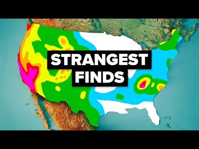
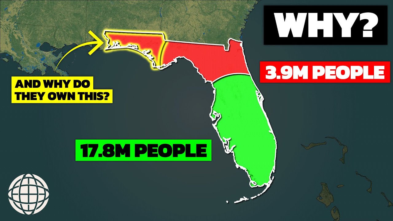
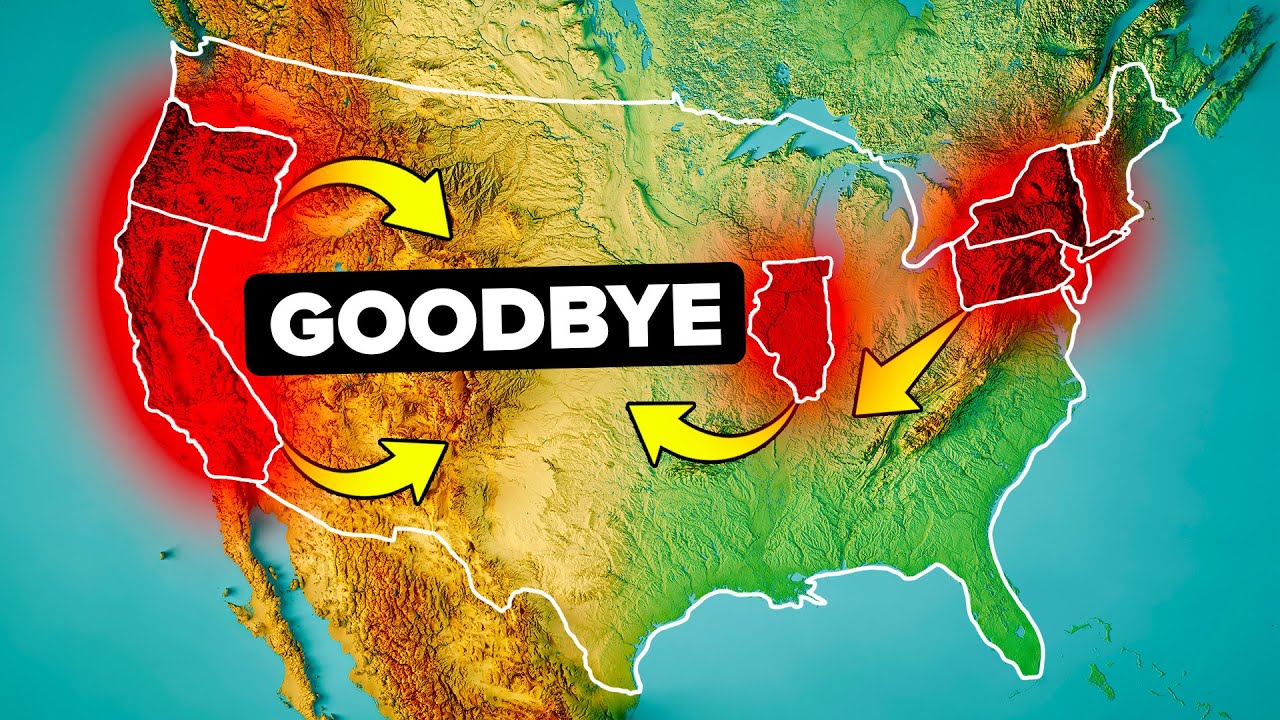
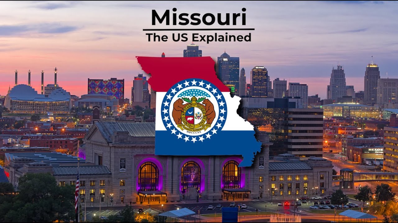
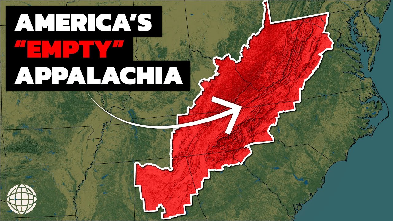
the United States of America possesses 3. 79 s million square miles of diverse territories lending astounding levels of diversity from one state to the next but for every beautiful Landmark the US has to offer there's something downright strange just around the corner locations that would make any traveler or even a native question exactly how it all came to be in this video we'll be taking a look at 25 of the country's Geographic Oddities that continue to befuddle the average americop file yes that's a real word as well as the reason they stand today have you ever noticed this disconnected piece of Minnesota known as the Northwest angle it is one of only six non- island hotspots identified as practical exclaves a part of one country that can only be entered via land route by passing through another country which in this case is Canada the area of this chimney is approximately 596. 52673200 with [Music] the northwest or the true shape of the Lake of the Woods which was instead shown as roughly oval during future treaties such as the Treaty of gent in 1814 the British suggested carving out a new boundary to run West of Lake Superior to Lake atasa the actual headwaters of Mississippi unfortunately at this point in time the love of expansion was already a part of the US's modus operandi and there was no way they would consider giving up land as there was a fear that this would set a precedent for all future negotiations so the Northwest angle or simply angle as the locals call it is here to stay our next stop is this town here Carter Lake at first glance you'd probably assume this is just another Nebraskan town that lies near the border of Iowa but the reality is it's actually a part of Iowa but unlike the Northwest angle which is clearly separated from the rest of Minnesota by water why is this town in exclave of Iowa the lake to the north from which the town gets its name was born in 1977 after a flood changed the course of the Missouri River 1 and a/4 miles to the southeast the development led to an arduous litigation process between Iowa and Nebraska where the Supreme Court ruled that Carter Lake belonged to Iowa what makes this so unique is that this defies the general rule that state boundaries follow the changes in the river as a result in July 1930 Carter Lake was incorporated as a city hosting two amusement parks in the early 20th century as well as becoming a place to gamble in the 30s and 40s with limited law enforcement thanks Mother Nature now quick let me ask you this which US state is closest to Africa most map enthusiasts might assume that it's Florida about 4,085 miles from gurara on top of that Florida's climate just makes you think that it would have to be Africa's closest Oceanic neighbor in the states alas you would be wrong it actually happens to be Maine more specifically a peninsula in the state known as quadi head which sounds like something out of Moby deck this little Lighthouse settlement is at the easternmost point in the US 3,154 mi from El bedua a rural commune in Morocco just over 900 M closer than Florida known for its Rocky Coastline and lobster Shacks the cool state of Maine seems like an odd location to be closest to the cradle of civilization and yet here we are just south of Main we arrive at New York City which has a rather unique governmental structure as you may know New York City is made up of five burrows for the uninitiated these Burrows are titled Manhattan Brooklyn Queens the Bronx and Staten Island each burrow is also equal to the county boundaries of the same name this group of counties cover a relatively small 322 square mies of land and yet each of these societal Pockets possesses its own class system and culture Manhattan acts as the seed of wealth housing most of the territory's skyscrapers multinational corporations Wall Street and the headquarters of the UN Brooklyn on the western tip of Long Island is the most populated out of the five and known for its diversity and thriving art scene Queens is the largest of them all founded by the Dutch it has reached major commercial success inspiring countless TV shows and movies the Bronx is home to Yankee Stadium and home to the largest metropolitan zoo in the world lastly Staten Island boasts unobstructed views of the Statue of Liberty along 28 miles of trails and the green belt but the strange thing about this layout is that the government of New York City as an entity supersedes the authority of each individual County so while County leadership would supersede a city in the other 49 states New York City is the exception traveling to the Midwest take a look at the Missouri boot heel a Salient or elongated protrusion that makes it look like Missouri has begun leaking into Arkansas the rest of Missouri's Southern border is a straight line so what happened here up until the 20th century the district was utilized for wheat and was full of Family Farms until the invasion of the notorious b Weevil a beetle that decimated the territory and sent everyone packing surprisingly this little piece of land was home to a number of Civil War battles too it was a hot bed for civil rights conflicts during the 1910s but origin Al the Missouri boot heill wasn't supposed to be included as part of Missouri during the formation of the Missouri Compromise the original border was supposed to be a simple extension connected to Kentucky and Tennessee but a man by the name of John Hardman Walker didn't like the sound of that idea he had grown up in the territory and after many had fled following the New Madrid earthquakes in 1811 Walker continued to buy land to expand his cattle business this led to him eventually being known as the SAR of the valley by 1818 Congress was brought into a dialogue with Walker and the local residents Walker who preferred the area and his Holdings to be under the protection of Missouri state laws lobbied in Missouri and Washington DC for inclusion of the boot heel within the boundaries of the state of Missouri on March 6th 1820 the Missouri territory requested admission into the union with the modified boundary the request was accepted and increased the total area of Missouri by 980 squ mil going from one Salient to another it's time to talk about another iconic geographical odity the Florida Panhandle bordering Alabama at about 200 m in length this Panhandle is one of only eight that can be found in the United States the 10 counties that inhabit the space are not only separated culturally with French influence being a common theme but they inhabit a separate time zone from the rest of the state using Central Time Well except Gulf County which is Split in Two by the Central and Eastern time zones but how did the Florida Panhandle come into existence and why wasn't it just included as part of Alabama the journey started in 181 while the Panhandle was still a part of Spain but American settlers in the territory found themselves closely identifying with the US and sent a petition to Congress asking to be incorporated into the Mississippi Territory but this more or less fell on deaf ears in 189 the Constitutional Convention of Alabama asked to join what was then known as West Florida to the new State again no such luck finally in 1821 Spain decided it was in their best interest to sell the territory at that point the Panhandle counties finally became a part of Florida which was admitted as a state in 1845 quite the roller coaster but here it stands today geography has its high points and low points in this case literally and figuratively another fascinating odity lies in the state of California California is one of the few places is where five major climate types occur in close proximity here the desert cool interior Highland and Steppy climates border a smaller region of Mediterranean climate half of all produce comes from the state's varietal landscape so it may come as no surprise that there are many Peaks and valleys to visit as a traveler in this particular instance the peak we're talking about today is Mount Whitney a 14,505 ft monster of a mountain and the culminating Summit of the Sierra Nevadas its neighbor sitting only 85 M apart from the high peak is the badwater Basin in Death Valley sitting at 282 ft below sea level what makes this fascinating or odd is that these are the highest and lowest points of the contiguous United States the country is about 3,000 M wide so the fact that Mount Whitney and badwater sit so close to each other is one of the craziest natural coincidences on this list across the US there's a clear hierarchy with the government you have cities that are part of counties which make up states which fall under the federal government in DC so it may surprise some to know that one state decided this hierarchy didn't apply to them that state is Virginia but why well it's a fairly complicated matter that can be traced back to the time of the colonies when the British were trying to encourage the creation of towns in order to better extract taxes from their subjects it was a feudal gesture and Virginia's eneral assembly held numerous meetings in an attempt to resolve the issue in later years the issue often stemmed from a lack of population density finally after World War I Alexandria County was the first in Virginia to have sufficient population density for local officials to provide Public Services equivalent to towns and cities the Supreme Court of Appeals ruled in 1922 that towns could not be created in Arlington County and its territory could not be annexed by the adjacent city of Al Alexandria so Arlington County was to be treated as an independent city and it was the first county in the United States to adopt the county manager form of government fast forward to the present day and many Virginia cities Statewide are completely separate from counties when it comes to jurisdiction City residents resolve legal disputes in separate courts from County residents cities and Counties have separate land use and transportation plants and in almost every case separate school systems as well in the end Virginia was going to do it their own way moving further south Texas is another member of the United States that definitely marches to the beat of its own drum as the second largest member of the Union it spans 268,000 the US in 1845 from rodeos to 10-gon hats to its iconic lone star flag Texas's presence looms so large that many on the outside believe Texans and Americans in general are one and the same all of this aside although many see Texas as the champion of the South some might be astonished to know just how South Texas actually is in fact if you look at a map of Deep South Texas you'll see its southernmost point dips almost as low as Miami the port of Brownsville is almost a straight shot to the party Capital about 1,29 nautical miles through the Gulf of Mexico at number 10 we'll be looking at another natural wonder Crater Lake located in South Central Oregon this volcanic crater lake is famous for its aesthetic alone drawing in a number of cross-country enthusiasts with its Rich blue color and up close Clarity no rivers flow in or out of it and it makes up for any loss of water through rainfall or snowmelt it also houses two small Islands uniquely named wizard Island a 316 acre cinder cone and a natural rock pillar called Phantom ship these facts are enough to catch one's attention but the Oddity lies in Crater lak's depth although the body of water is only about 5 to 6 M across its maximum depth is 1,949 Ft making it the deepest lake in all of the United States excluding Lake vasto in Antartica Crater Lake is cited as the seventh deepest lake on the planet all of this is the product of volcanic activity from Mount Mazama it's estimated that about 720 years was required to fill the lake to its present depth of 1,949 Ft much of this occurred during a period when the prevailing climate was less moist than at present some hydrothermal activity remains along the lake floor suggesting that at sometime in the future Mazama May erupt once again with that said Crater Lake is not the only mover and Shaker on this list when thinking about earthquakes we often jump to highlighting activity on the west coast in places like California after all there was a shock on April 10th 1906 off the Northern California coast that smashed City Hall and triggered a fire that scorched 28,000 buildings with a death toll that may have exceeded 3,000 for these reasons many reasonably assume that the San Andrea's fault is an apocalyptic concern inspiring ing a number of films like 2012 starring John cusac believe it or not the two biggest earthquakes in recorded US History outside of Alaska occurred far far away from the San Andreas fault they actually took place in Missouri and South Carolina known as the New Madrid earthquakes named after the New Madrid seismic Zone which was in turn named after the Mississippi River Town of New Madrid there was a series of quakes that occurred between 1811 and 1812 the the first one hit a recorded magnitude of 7.
2 to 8. 2 at the time their area was sparsely populated so it didn't have the same effect as what took place in California the last quake packed quite the punch though shaking at a magnitude of 7. 4 to 8.
6 the town of New Madrid was destroyed in St Louis Missouri many houses were severely damaged and their chimneys were toppled to this day many Eastern residents are warned that such an earthquake could come come again in the next 50 or so years cleansing our pallets it's time to look at another Panhandle if you look closely at the northwest corner of the Panhandle where Texas joins Oklahoma and New Mexico you'll notice that the lines aren't perfectly aligned after going down the edge of Oklahoma the Border goes 2. 3 mil to the left before continuing in a straight line South a couple miles is no big deal right well this is often referred to as the worst surveying area error in United States history let's get a bit deeper here this error actually goes far beyond the previously cited 2. 3 Mi it actually gets bigger as it continues South 310 Mi to the bottom Texas New Mexico corner where it turns West and heads for El Paso all totaled the mistake accounts to a 942 s m pickup to add insult injury all of this land should have technically gone to New Mexico so what happened well in 1859 a man named John H Clark was paid to survey and install monuments along what is called the 103rd Meridian which aligns with where we see Oklahoma's border meet New Mexico today Clark began on the southern end of today's Texas and New Mexico border and made his way northward until he no longer had a water source sounds reasonable enough but there was a small problem on top of this problem while connecting the lines he was frightened by the natives in the region and decided to stop 70 M early this leads us to the third problem though even if he wasn't running away he still wouldn't have successfully drawn a connecting line it turned out that his math was wrong and he was off by the 2.
3 Mi we see on the map today but it's more than that when you calculate the narrow strip of land that should have been New Mexico it amounts to 63,360 Acres but due to laziness or a lack of scrutiny the boundary was accepted and certified in 1891 in 1910 when New Mexico was ready to become a state the error was discovered and New Mexico made a push to reclaim the territory however within the strip of land that would then become part of New Mexico was the exit Ranch whose primary investor a man named John Farwell was also a friend of then President William Howard Taft not wanting to lose any land rights Farwell successfully persuaded President Taft to tell New Mexico to leave the Border as it was or forget becoming a state entirely New Mexico understandably backed down and the Border remained as it is today speaking of boundaries some are just as deliberate as they are bizarre for example have you ever noticed that the top of Delaware is round this is because of something known as the 12m circle a circular Arc that makes up the boundary between Delaware and Pennsylvania extending out from the Delaware town of Newcastle like many a of the Eastern United States the start of this line dates back to King Charles II who in 1681 granted a deed to William Penn the circle was the product of the Monarch's exception to accommodate the needs of the Duke of York who had won the area after a victory against Dutch colonists the Duke later gave the lands to Penn a year after the agreement the circle isn't without controversy though of note is the fact that the circle claims that the entirety of the Delaware River is part of Delaware's territory normally a water border is split evenly down the middle but this claim over the entire Waterway has sparked government disagreements between Delaware in New Jersey ever since although the Supreme Court attempted to put these concerns to rest they continue to battle over the odd boundary with Delaware even going as far as to request the National Guard for security in the early 2000s this however was ultimately a symbolic gesture for the time being though it's clear that Delaware's cllean to the river will stand sticking with Delaware for a moment longer this is a case where physical and man-made geography meet we're talking about the Delaware Peninsula or Del Marva Peninsula depending on who you ask Delmarva is an East Coast peninsula portmanto made up of parts of Delaware Maryland and Virginia although Delmarva is owned by three different governments who probably secretly wish to own it all themselves it is a land mass that has since developed its own separate culture in fact many are quick to point out that Del Marva has a distinct accent and way of speaking additionally there have been efforts by the people to secede but these efforts have proven to be unsuccessful if they ever managed to break away from the mainlanders as they call them the total population would be about 1. 4 million similar in size to Hawaii this is one of those rare cases where separation does appear to make a bit of sense considering that the people of Delaware Maryland and Virginia appear to support their independence for variety of reasons Independence or not Delmarva definitely deserves its place on this list at number 15 take a look at this protruding piece of border on the northwest corner of Pennsylvania in this area we have what is known as the Eerie triangle a 300 squ M piece of land that was a fairly hot button issue between five states as well as Native American tribes each argued their claim to the land as it represented valuable access to the Waters of Lake y when Native American leaders heard of Pennsylvania's intent to access the land they voiced their opposition saying we must observe to you that we are sent in order to make peace and that we are not authorized to stipulate any particular session of lands they also encouraged their people to actively oppose any attempts by American settlers to occupy the land the opposition was not enough however and the US government ultimately approved a sale of the land to Pennsylvania in 17 1992 the Native American tribes were paid $2,800 from Pennsylvania and $1,200 from the federal government unsurprisingly this didn't plate the trib's concerns and conflict erupted in that region but after the group's defeat by the United States Army in 1795 the tribes relented and Pennsylvania's chimney was set in stone our next Geographic odity brings us to Bristol a city split in half by the states of Virginia and Tennessee in 1771 a trading post was constructed to serve Travelers heading west for a better life after about 1856 it reportedly prospered after the link between the Norfolk western and southern Railways was finally joined two communities were given City charters in 1890 with the name Bristol triggering a pretty heated boundary dispute until 1901 when a line virtually have the settlement along the center of State Street upon closer inspection there are markers to indicate the SE operation and the dispute for the most part ended amicably like Del Marva both halves of Bristol share the same culture in quirks with nothing separating them other than the invisible line separating all states in the union while some boundaries are fixed other boundaries change by the season meet Maryland a state well known for its extensive waterways with a major historical sea port located in Baltimore due to its terraqueous nature water rites take up a large portion of Maryland's legal disputes especially when it comes to its boundary issues with Virginia for decades both states have entered numerous negotiations regarding control over the pomac river 400 m long from its Headwaters at North Branch to its mouth in the chesap bay it ranks 48th among 135 Us Rivers that are more than 100 m long the river is about 11 M wide between Point Lookout and Smith Point ultimately Maryland owns everything up to the low water Market on the Virginia side what makes this especially strange is that rainfall essentially dictates how large Maryland is in a given year if the season proves to be wet the water level in the pomac will rise technically expanding the size of Maryland for the duration of that particular period at number 18 we have another exclave this time it's the famous Kentucky bend a child of the Mississippi River encircled by the states of Missouri and Tennessee as of the 2020 census the population was nine persons in this area tabulated as the Kentucky Bend census County division the mailing address of the area is Tiptonville Tennessee New Madrid Missouri is directly across the river to the north but it isn't connected to the bend by Road or Ferry covering an area of 26.