Earthquakes in California: The Hidden Threat Beneath Los Angeles Just when our videos were drawing attention to the dangers of seismic regions like New Madrid and Cascadia, with the cry of "forget the San Andreas Fault, the real danger doesn't come from there! ". .
. here come a couple of significant earthquakes in California, even in the heart of Los Angeles, putting the Big One back in the race as the "most dangerous upcoming earthquake" contender! As you may recall, just over an hour after sunset on August 6, 2024, a sparsely populated strip of farmland near Bakersfield, Southern California, was shaken by a magnitude 5.
2 earthquake, followed by hundreds of smaller aftershocks. According to California standards, this wasn't an unusually severe event. The state is the second most seismically active in the United States after Alaska, with Southern California experiencing an earthquake on average every three minutes.
While most are too small to be felt, about 15-20 events exceed magnitude 4. 0 each year. This recent magnitude 5.
2 earthquake is the strongest to hit Southern California in the past three years. The epicenter was about 17 miles (27 km) south of Bakersfield, California, and people reported feeling the tremor nearly 90 miles (145 km) away in parts of Los Angeles and as far as San Diego. Then, at 12:20 PM local time on August 12, another tremor shook the Los Angeles area due to a rupture on a small section of a minor fault independent of the San Andreas.
The resulting magnitude 4. 4 earthquake had its epicenter just four miles (6. 4 km) northeast of downtown and at a depth of about 7 miles (11 km).
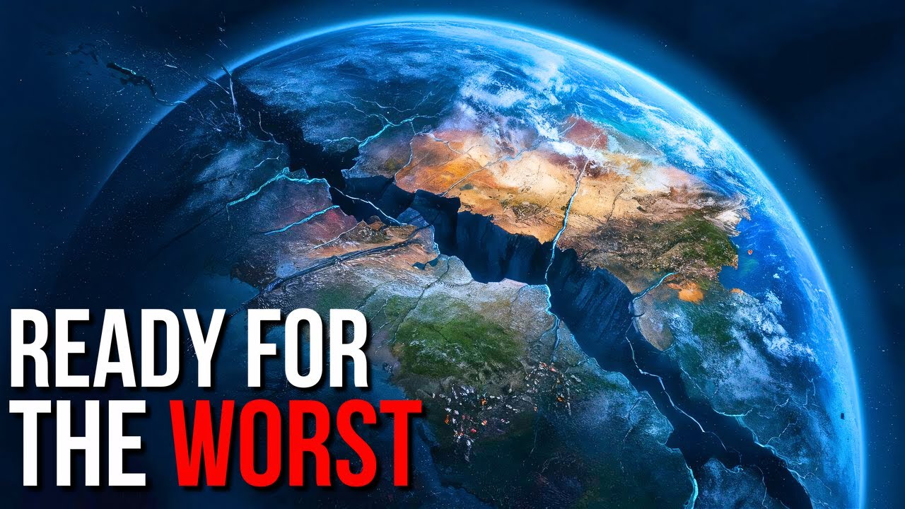
Given the densely populated area, the tremor was felt not only throughout the city but also in San Diego – about 124 miles (200 km) from the epicenter – and in Orange County, home to the famous Disneyland amusement park. Despite this, the tremor did not cause significant damage. From a geological perspective, none of this should surprise us, given that the area is particularly seismic: along the entire western coast of the USA, there is a complex fault system, the most notable of which is the San Andreas Fault: a structure about 800 miles (1,280 km) long, 10 miles (16 km) deep, and made famous by the "Big One," a journalistic term referring to the much-feared earthquake that could strike California sooner or later.
Specifically, this term refers to a tremor of at least magnitude 7. 0 on the Richter scale: the last major earthquake associated with the fault dates back to April 18, 1906, with a magnitude 8. 3 quake that caused destruction and fires in the city of San Francisco.
However, putting the past aside, can these two tremors really make us fear that the San Andreas Fault has started moving? No more Cascadia, no more New Madrid. .
. Do we have to deal with the Big One again? But then, are we really sure that the Big One would mean the complete destruction of Los Angeles, San Francisco, and the surrounding areas?
Let's try to clarify with this exciting video! “Roll intro” Have you seen the movie San Andreas, which hit theaters a few years ago? The latest Hollywood blockbuster about natural disasters played on the fears of residents of the US West Coast, offering a glimpse of what will happen when The Big One, the predicted mega-earthquake, actually strikes.
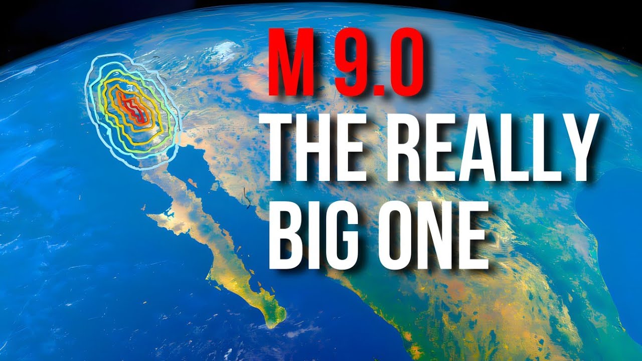
Well, after hearing about the recent seismic activity in California, I felt the need to rewatch the film, especially to immerse myself in the right context before voicing this new video. As you may recall, the film depicts a sudden magnitude 9. 6 earthquake hitting California.
The long-awaited gigantic earthquake levels the metropolises along the infamous San Andreas Fault. Los Angeles, San Francisco, and their surroundings are plunged into chaos. Triggering violent tremors from the depths of the earth, the disaster sparks fires, power outages, and the mother of all tsunamis.
Setting aside the protagonist's improbable stunts, it's worth noting that the film gets at least one thing right: the basic safety measures an individual should follow during an earthquake. Throughout the film, the characters demonstrate that in the event of a tremor, they should immediately drop to the ground and hide under sturdy objects. They also know that if the sea recedes along the coast, it means a tsunami is coming.
Early warning systems also blare along the coast, urging people to move to higher ground. In short, watching the film is like participating in a rudimentary survival course. And that's something.
However, there are many other things in the film that don't add up. For example, the initial tremors of magnitude 7. 0 and 8.
0 on the Richter scale cause much more damage than they would in reality in a city where most buildings are constructed with seismic safety standards. "before moving on, don't forget to subscribe to our channel if you haven't already . .
. make sure to hit the notification bell so you don't miss out on our daily videos! " We know.
. . directors and screenwriters have to exaggerate, multiplying the disasters and their consequences tenfold and a hundredfold.
But in reality, even the most devastating earthquakes, like the magnitude 7. 9 that hit Nepal in 2015, wouldn't cause the collapse of most buildings as shown in the film. And if I mention this earthquake, which happened many years ago, it's because a survey by the Nepali Engineers Association found that only 20 percent of buildings suffered severe damage from that quake.
About 60 percent of the buildings that collapsed in the area were made of masonry and lacked steel structures, construction methods banned in California since 1933! The film then ventures into science fiction when the geologist character played by Paul Giamatti goes on national TV to announce the start of a "swarm," a series of earthquakes that would spread from Nevada to San Francisco. According to his "magnetic earthquake prediction model," the geologist also warns Americans that The Big One will eventually hit San Francisco with a magnitude of 9.
6 and that its impact will be felt even on the East Coast. Its force, he says, will be such that "the ground will literally split open. " Sure, seismic swarms are real phenomena: several earthquakes can indeed occur over a relatively short period.
However, these types of earthquakes generally have a fairly low average magnitude and do not produce a distinguishable main earthquake. While a swarm might explain the continuous earthquakes depicted in the film, they certainly wouldn't be able to produce individual destructive tremors! Then there's the issue of the tsunami, which in the film completes the destructive work of the earthquakes.
One thing is certain: even in the face of a massive earthquake, a tsunami – even a modest one – will never occur as a result of a slip on the San Andreas Fault. The fault is located inland, far from the coast, whereas for a tsunami to occur, the earthquake would need to manifest on the ocean floor or at least very close to the sea. Many of the characteristics of the tsunami depicted in the film – as you might imagine – were created for dramatic effect and are inaccurate.
For example, a tsunami would never form a wave of that size in shallow waters near the coast. Additionally, tsunami events typically have multiple waves, and the first one is not always the largest. In short, the film greatly exaggerates the destructive power of a natural phenomenon like a fault rupture and blatantly evokes impossible scenarios, such as being able to predict the location, time, and intensity of its occurrence.
The first thing to know is that the San Andreas Fault is not long and deep enough to trigger a magnitude 9 or higher earthquake like the one depicted in the film! The largest historical earthquake triggered on the northern part of the fault was the magnitude 7. 9 earthquake of 1906, and computer simulations show that the fault is capable of producing earthquakes up to a maximum magnitude of 8.
3, which is an event almost a hundred times weaker than the magnitude 9. 6 quake that devastates San Francisco in the film! Another thing to consider is that all the most recent earthquakes, including the magnitude 6.
2 quake on August 24 in Napa Valley, have occurred along the northern and central parts of the fault. In the southern part, however, no earthquakes of greater than magnitude 7 have occurred for nearly 300 years. And it is precisely from here, where much more energy may have accumulated, that experts predict the arrival of the Big One.
Yes, but when? Well, according to the group of scientists from the Uniform California Earthquake Rupture Forecast, there is a 99. 7% probability that an earthquake of magnitude 6.
7 or greater will occur in California within the next 30 years and a 46% chance that the quake will be greater than magnitude 7. 5. The probabilities are higher in the south (37%) than in the north (15%).
The Big One has a 67% chance of hitting the Los Angeles area and a 63% chance for the San Francisco Bay Area. If the Big One were to hit the area most likely indicated by studies, it could destroy Palm Springs and many cities in the San Bernardino and Riverside regions of California. The effects could be very severe for all of Southern California, including the major metropolises and densely populated areas of Los Angeles, Orange County, San Diego, and Tijuana.
No need to worry, though. . .
The scenario seems catastrophic, but there are also those who argue otherwise. In a study published in the Bulletin of the Seismological Society of America, seismologists from San Francisco analyzed data recorded since 1776 from the first Spanish missions and those collected by observing fault displacements. It turns out that between 1690 and 1776, earthquakes with magnitudes between 6.
6 and 7. 2 occurred, releasing energy similar to that of 1906. According to the researchers, the geological characteristics of the San Francisco area make a scenario of intense and frequent earthquakes more likely than one involving a highly destructive earthquake.
So, who should we believe? My answer is: no one who claims to see the future. A certain amount of trust should only be given to those who, in the tradition of scientific inquiry, hypothesize scenarios in terms of probabilities rather than absolute certainties.
. . but above all, it is absolutely necessary to have faith in preventive engineering, that is, the ability to construct buildings to seismic standards.
However, contrary to what I've done so far, I want to end our chat by suggesting an additional danger for California residents. . .
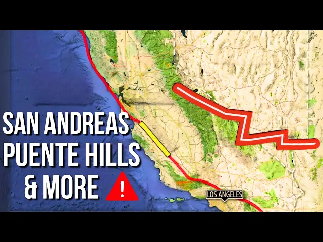
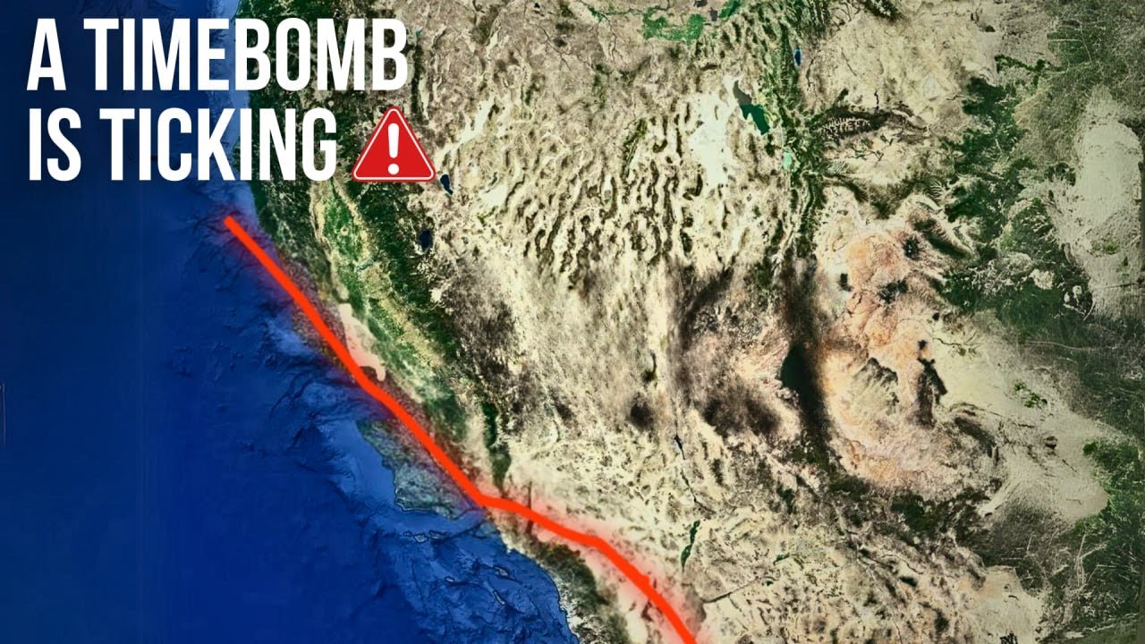
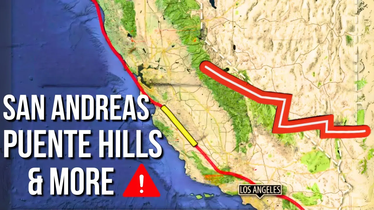
For over a century, Los Angeles has feared the infamous San Andreas Fault and focused solely on it. But its residents may be overlooking a much closer and even more lethal monster: the Puente Hills Fault, which could kill more people and cause much more damage, being located right beneath the oldest and most vulnerable neighborhoods. A study by the University of Southern California states that Puente Hills has the potential to produce "the most costly disaster in U.
S. history. " Up to 18,000 people could die, 735,000 could lose their homes, and up to 100,000 tons (90,718 metric tons) of debris could be generated.
The total economic loss would amount to $252 billion. The United States Geological Survey has presented similar projections, noting that the destructive power of Puente Hills is five times that of San Andreas. A magnitude 7.
5 earthquake on the nearby Puente Hills Fault would cause the same destruction as a magnitude 8. 0 earthquake on the more distant San Andreas, with a magnitude 8. 0 earthquake releasing 16 times the energy of a magnitude 7.
5 earthquake. According to statistics, the rupture of the Puente Hills Fault occurs once every 3,000 years. Note for editor: Here's the improved and translated version of your additional text, with double units of measurement added where necessary: The fault, first discovered in 1999, extends for about 25 miles (40 km) across the Los Angeles Basin, from downtown to the southeastern part of the county, reaching into Orange and San Bernardino counties.
The magnitude 6. 0 Whittier Narrows earthquake in October 1987 led to this discovery. This was followed by the Chino Hills (2008), Pico Rivera (2010), and La Habra (2014) earthquakes.
In 2017, a team of Harvard scientists produced a report showing an acceleration in the slip rate along this fault. An increase that implies that the magnitudes and/or frequency of earthquakes on this fault segment are increasing over time. These faults also pose an additional danger because they are located along the Los Angeles Basin, where local soil conditions are prone to liquefaction, a phenomenon that causes the ground to move like jelly when shaken.
When this phenomenon occurs under vulnerable buildings and other structures, the consequences can be catastrophic. Well. .
. guess which fault triggered the magnitude 4. 4 earthquake on August 12?
That's right, right under Los Angeles, on the Puente Hills Fault. Scared? No, you shouldn't be.
. . everything will be fine.
. .