The Feared Cascadia 9. 0 Earthquake: Potential Consequences are Scary. Who could have imagined that a monster earthquake in the Cascadia subduction zone could leave a lasting impact on the environment for over 2,100 years?
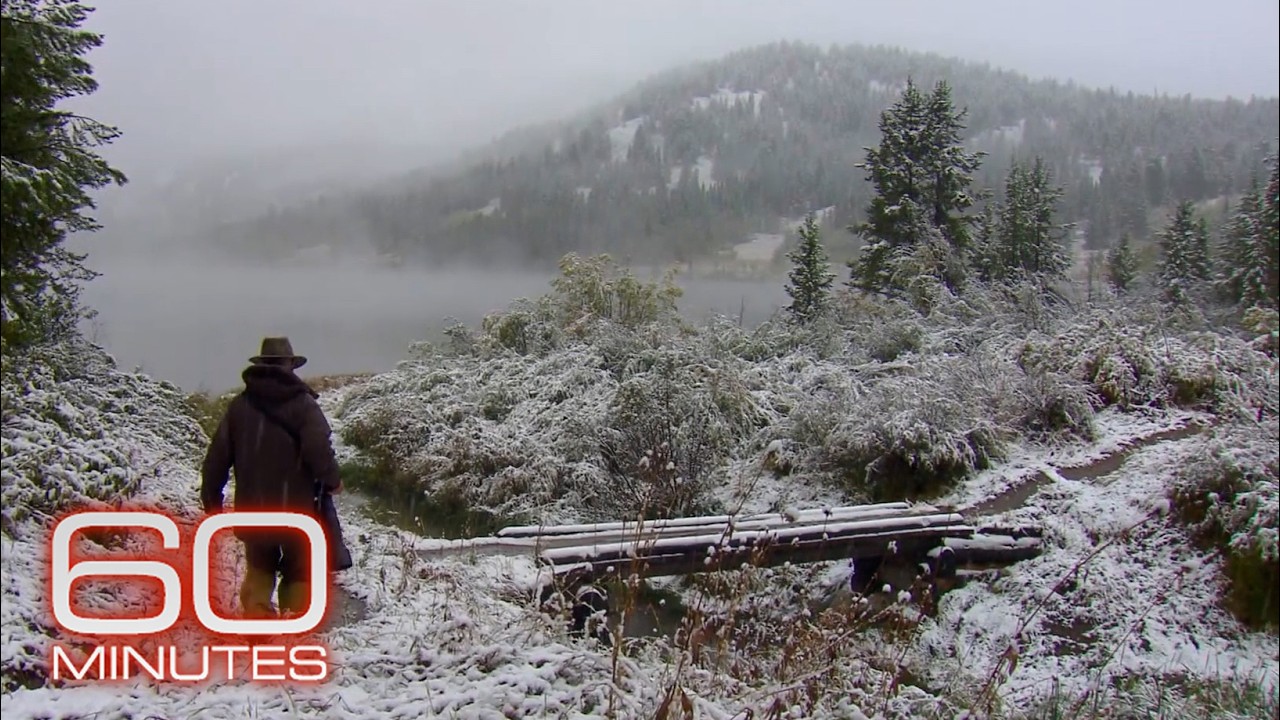
Yet, that's exactly what we see on an Oregon beach south of Neskowin, where a haunting "ghost forest" of dead trees tells the horrifying tale of a seismic event of unimaginable proportions. To grasp the potential scale of the impending Cascadia 9. 0 earthquake, we must travel back in time to see exactly what happened here and compare that with current observations.
Let’s dive in! The United States has a long history of major earthquakes, dating back to when humans started keeping records of these disasters. Take California, for instance, where earthquakes occur daily, although most are too small to notice.
The USGS has set up a large network of sensors to detect these tremors. However, one of the most notable earthquakes in US history struck the Oregon Coast several centuries ago, causing significant damage in the Cascadia subduction zone. Keep watching as the impact of this past megathrust earthquake might be our only clue into the feared impending Cascadia 9.
0 earthquake. Around 2,100 years ago, a cataclysmic event led to the creation of numerous "ghost forests," with some located over a mile inland. This disaster devastated millions of trees across a 620-mile stretch from Eureka, California, to the western part of Vancouver Island, Canada.
Within just 3 to 5 minutes, the ground across approximately 55,000 square kilometers—equivalent to the size of West Virginia—sank by 2 to 6 feet. Most of this subsidence occurred underwater, but a portion affected land, submerging previously healthy coastal forests below sea level. Following the ground subsidence, a powerful tsunami struck, flooding areas up to 10 miles (16 kilometers) inland.
The saltwater overwhelmed the trees, which were already stressed by being submerged, leading to their rapid demise. The remains of these trees became petrified, lying below high tide for centuries. Eventually, geological processes like sediment deposition and long-term uplift moved the shoreline westward, revealing the ancient remains of the trees.
The existence of multiple ghost forests along the Cascadia Subduction Zone is a harrowing reminder of the region's seismic history. These forests, formed as a result of massive earthquakes, have differing ages, with the Neskowin ghost forest dating back to around 100 BCE and the Copalis ghost forest forming in 1700. The fact that additional large subsidence events have occurred between the creation of these two ghost forests suggests that more ghost forests may have formed around 400, 700, 1150, and 1470.
The culprit behind these disasters is a megathrust earthquake, a type of earthquake that occurs when one tectonic plate is forced beneath another. These massive earthquakes, which can range from 7. 5 to 9.
2 in magnitude, seem to repeat every 250 years, although the interval between major events has varied significantly. The last major Cascadia megathrust earthquake occurred 324 years ago, and since then, the population in the region has grown by 20 million people. This raises concerns about the potential impact of the next major Cascadia subduction zone earthquake.
To better understand the risks, let's consider how the modern West Coast of the United States and Canada might fare if an earthquake of the same magnitude as the one in 1700 were to occur today. Assuming the next megathrust earthquake takes place at 9 am local time on a future date, we can superimpose the damage, tsunami heights, and other effects from the 1700 earthquake onto the modern world. This thought experiment would provide a clearer glimpse into the potential consequences of such a disaster.
Let’s get into it! Picture this: In the not-so-distant future, the offshore Cascadia subduction zone is experiencing its usual tectonic dance. Here, the Juan de Fuca Plate is slipping beneath the North American Plate, a process that's been happening for over 300 years.
The friction between these plates causes the North American Plate to bend downward toward the subducting slab. Over time, stress builds up until, finally, it surpasses the friction holding the plates together, causing the overlying plate to snap back upward. It's now 9:00 am.
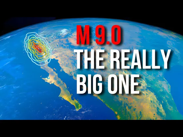
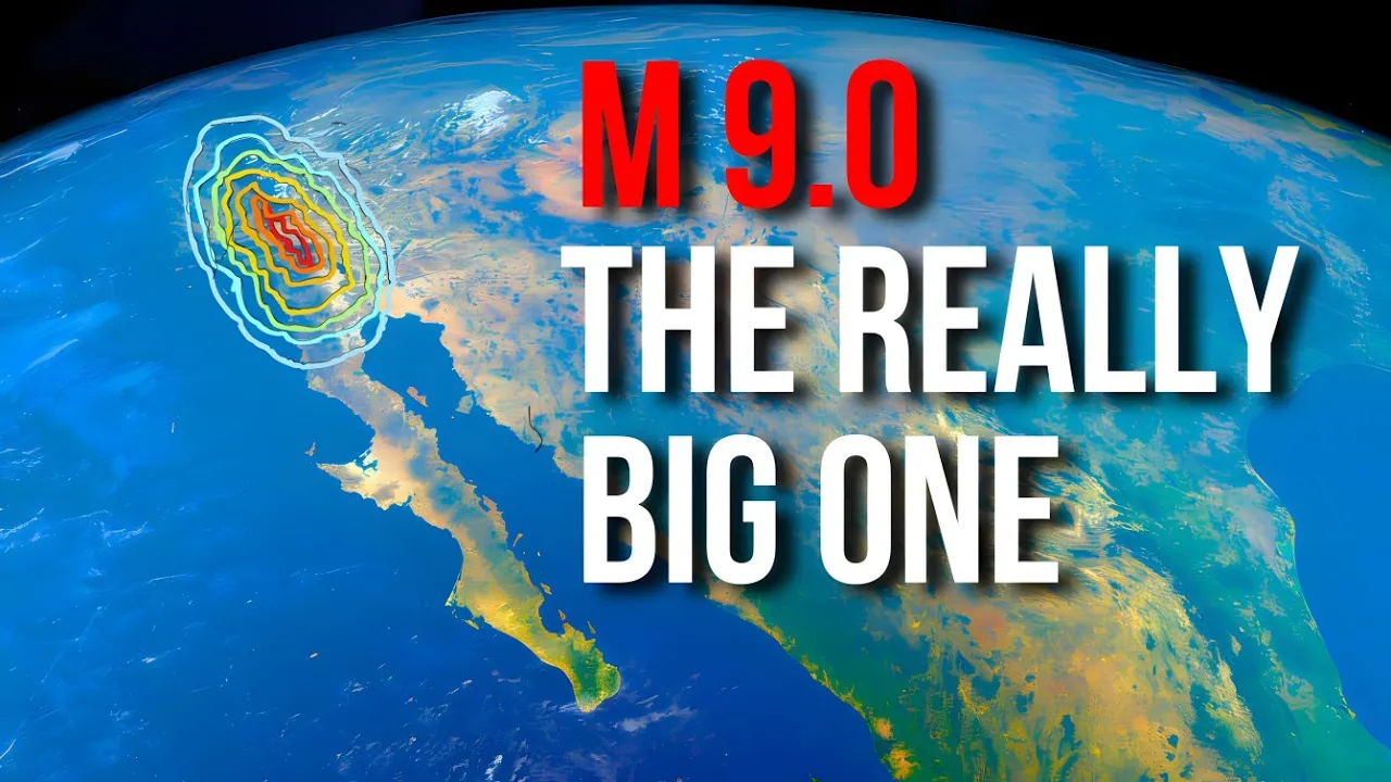
Suddenly, a magnitude 9. 0 earthquake erupts. The epicenter lies 13 miles deep, approximately 48.
5 kilometers west of Lincoln Beach, Oregon. Simultaneously, a rupture extends along a 620-mile stretch of the subducting slab, sending P and S seismic waves racing outward at speeds of 5. 5 and 3.
1 kilometers per second, respectively. This rapid upward snap of the North American Plate displaces a massive amount of ocean water, generating a towering tsunami. Just 5.
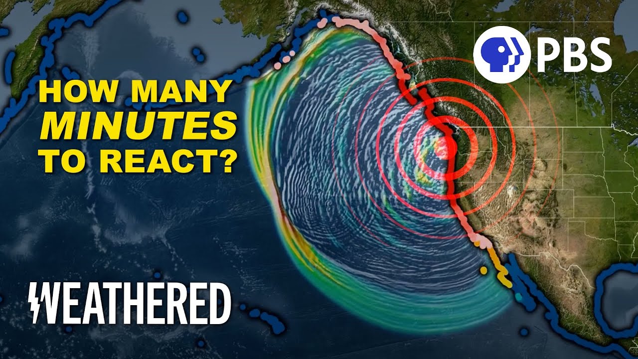
4 seconds later, a seismic station 18. 2 miles away detects a strong spike from the earthquake's P wave. Instantly, it sends a signal to a server, which then dispatches millions of alerts to every phone with internet access.
Within seconds, people receive warnings that a major earthquake is underway and that intense shaking will follow shortly. For context, let’s explain the P and S waves. Imagine you're standing in a field when an earthquake hits - the P (primary) waves are like a loud noise that travels through the air, compressing and expanding the ground in a push-pull motion, while the S (shear) waves are like a sideways jolt that shakes the ground from side to side, making it hard to stand upright.
Think of P waves as a row of people doing a "wave" motion with their arms, moving forward and backward, while S waves are like a row of people holding hands and swaying from side to side. Hey, guys, just a moment Before we continue, be sure to join the Insane Curiosity Channel. .
. Click on the bell, you will help us to make products of ever-higher quality! Let’s get back to the thought experiment.
Eight seconds after the quake began, the first seismic waves reached Lincoln City, one of the closest towns to the epicenter. The ground shook violently for 11 seconds before the more destructive secondary waves arrived, changing the motion to an intense up-and-down jolt, accelerating to half the force of gravity. Shortly after, other seismic waves, like the Love and Rayleigh waves, followed, escalating the destruction.
Inside buildings, items flew off shelves, heavy furniture toppled, and light fixtures crashed to the floor. Outside, roof tiles were flung off, chimneys crumbled into piles of bricks, and cracks appeared in walls and foundations. This scenario applies to wooden and reinforced steel buildings.
If you were in a nonreinforced brick structure, it would likely collapse, with slightly better odds in a concrete building. This relentless shaking persisted for a grueling five minutes, feeling like an eternity for those caught in the catastrophe. This description covers MMI 8 damage, impacting major cities like Crescent City and Newport.
MMI 7 intensity shaking would reach Seattle, Portland, Tacoma, Medford, Redding, and Victoria. MMI 6 shaking would hit Vancouver, Klamath Falls, Chico, and Port Hardy, while MMI 5 shaking would affect San Francisco, Sacramento, Reno, and Bend. Cities experiencing an MMI of 5 or higher would sustain some form of damage, while those at an MMI 7 or higher would witness many masonry structures collapse.
In addition to the structural damage, millions, if not billions, of trees would fall, and tens of thousands of landslides would occur, wiping out hundreds to thousands of structures from Vancouver to Redding. These landslides could strike any area experiencing at least MMI 4 shaking, becoming more common with stronger ground motion. Regions with steep, rugged terrain would be most vulnerable.
If you lived near a beach, close to an active river, or in an alluvial plain with sediment-containing water, your home could face another potential hazard leading to collapse. Why? In areas with abundant groundwater, the underlying soils held together by friction could shift, causing water to be expelled and the ground to subside unevenly.
This could lead to the ground collapsing beneath a building in a process known as liquefaction, likely affecting tens of thousands of buildings. While tens of thousands of casualties would have already occurred as the devastating seismic waves took varying times to reach major cities, the most devastating threat had yet to arrive: a monster tsunami. How will Tsunami Aggravate This Catastrophic Event?
Tsunamis are massive ocean waves that can bring about catastrophic destruction when they reach land. Although they can be triggered by various geological events, such as underwater landslides or volcanic eruptions, the most devastating tsunamis are often generated by powerful megathrust earthquakes that occur along subduction zones. The Cascadia subduction zone, located off the Pacific Northwest coast of North America, is a region prone to producing powerful tsunamis.
The process of tsunami generation from megathrust earthquakes is relatively simple. In a subduction zone, one tectonic plate is forced beneath another, creating a steep and narrow trench on the seafloor. When a large earthquake strikes along the subduction interface, it causes a sudden vertical shift of the seafloor, which in turn displaces the overlying water column, generating a tsunami.
The size of the tsunami wave depends on several factors, including the magnitude of the earthquake, the amount of seafloor displacement, and the geometry of the subduction zone. Larger earthquakes that produce greater vertical uplift tend to generate bigger tsunami waves. Additionally, subduction zones with a steep offshore slope, such as the Cascadia region, are more likely to produce destructive tsunamis.
Now, let’s look at the hypothetical scale of the tsunami that would be generated in such an event. Within 20 to 35 minutes after the quake, the ocean would start to recede noticeably, pulling back up to 1,000 feet from the shoreline. This sudden retreat of the water is a classic warning sign of an impending tsunami.
Unfortunately, this phenomenon would only give you a few seconds, or at best a few minutes, before the towering waves came crashing back in. The height of these tsunami waves would vary depending on location. In Northern California, they would largely be 13 to 20 feet tall.
Further north, in Oregon, they would range from 20 to 43 feet. And in Washington, the waves could reach a staggering 20 to 115 feet in height! Even Seattle would be impacted by an estimated 5-foot tsunami.
Entire coastal towns would be inundated, with water flooding up to 10 miles inland - the extent of the damage largely dependent on the local topography. Tragically, this scenario could lead to tens of thousands of casualties during this initial tsunami onslaught. The devastation wouldn't stop there, as multiple tsunami waves would continue to strike the coast over the course of several hours.
And to make matters worse, there's also the potential for a disastrous chemical spill along the Willamette River, which could kill 2,500 people and injure 17,000 in Multnomah County alone. As the tsunami radiates out across the Pacific, it would bring 10 to 20-foot waves to much of Hawaii, likely causing significant damage in Hilo. Parts of southern Alaska, including Kodiak and Cordova, would also be hit by 10-foot waves.
The overall toll of this catastrophic event is staggering. Experts estimate that it could result in 16,000 to 65,000 deaths, and 25,000 to 30,000 injuries, and leave 100,000 people homeless. The financial damage is projected to be around $270 billion - though some experts believe this figure may be an underestimate.
And the troubles wouldn't end there. The major earthquake would likely be followed by a powerful aftershock, potentially registering between 7. 8 and 8.
1 on the Richter scale, along with thousands of smaller aftershocks. What's more, the shaking could even trigger volcanic eruptions in the Cascade Range, potentially including a medium-sized eruption of Mount St. Helens.
Of course, the severity of this scenario depends on the magnitude of the earthquake, with a 7. 5 quake likely causing much less widespread and severe damage than a 9. 0 to 9.
3 event. Nonetheless, the risk of a major Cascadia megathrust earthquake is estimated to be about 1 in 250 each year. The implications of such an event are truly staggering to contemplate.
Do you think the next Cascadia earthquake will happen anytime soon? Is there a region you think we should estimate the scale of potential impact in comparison to past disasters? Share your opinion in the comments below.
Click on the next video that pops up on your screen. It explains why the new Madrid fault disaster could hit the middle of the U. S!
Thanks for watching.