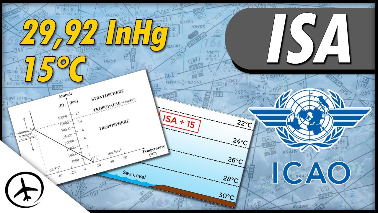
Today we are going to talk about the ISA atmosphere Which is also known in aviation as "Standard Conditions" First of all, let´s see what ISA stands for ISA stands for "international standard atmosphere" Or in spanish "atmósfera estándar internacional" This is an atmospheric conditions model adopted worldwide as a datum When I say "atmospheric conditions" I refer mainly to The specific values of air temperature and pressure at different altitudes This model was created by the Internacional Civil Aviation Organization (ICAO) In the 1950´s This is the reason why sometimes ISA is refered as "ICAO Standard Atmosphere" Or in spanish "atmósfera tipo de OACI" Once the model was created, it was published in the ICAO Doc. 7488 where all the parameters that were used were specified But the question is: what is the ISA atmosphere for? Well.
. . .
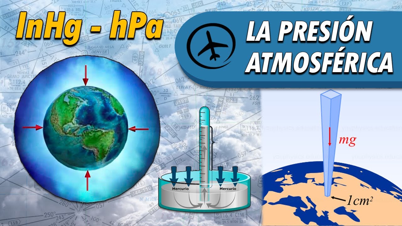
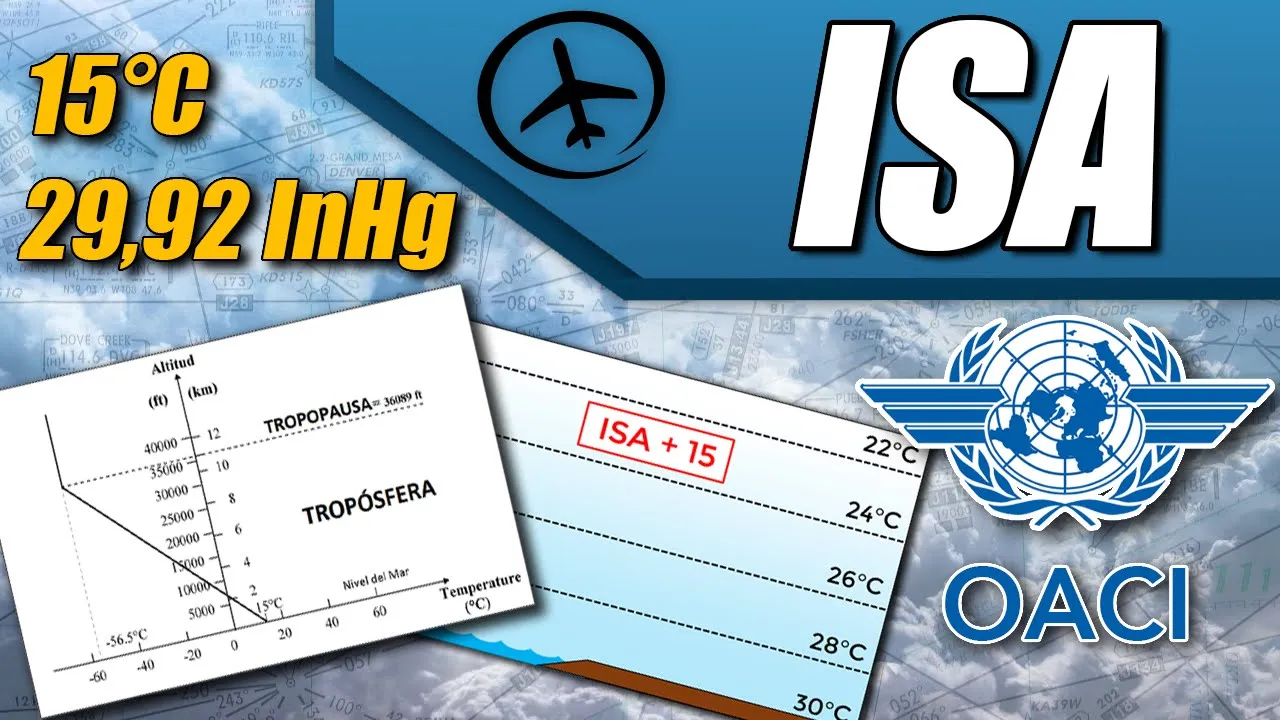
First of all we must say that the atmospheric conditions are constantly changing every day And they are also very different depending of the geographic location Let´s see an example of this Here we have two people One of them is in the coast of a tropical area And the other one is in the coast of a colder area In this case, the person who is in the tropical coast, would say that the normal temperature at sea level is aprox. 30°C While for the other person, the normal temperature at sea level is aprox. 5°C As we can see, for a specific altiude, in this case 0ft (Sea level) We have two different reference temperatures Depending of the conditions of each place This is why it is necessary to have a standard universal reference with which the different conditions can be compared This is one of the reasons why the ISA atmosphere model was created, also known as "satandard conditions" So having said that, let's look at the ISA model in detail The ISA model assumes that the air is an ideal gas that means that it has no dust particles, salt or moisture That is why in this model we can apply the formula of ideal gases Even if in reality the air isn´t an ideal gas Now, with this in mind, the ICAO stablished certain reference values For the air temperature and pressure at different altitudes in the ISA model Which we will see in detail now First of all we must say that, in general terms, the atmospheric pressure and the air temperature decrease with altitude For example, if we observe the air that is right on the surface (Sea level) We will notice that it has a higher temperature and pressure compared to the air that is at higher altitudes With this in mind, let´s now see how does the air pressure behaves in the ISA model The model assumes that the standard pressure at sea level is 29,92 InHg Or 1013,25 hPa depending on the measurement unit we are using and the model also assumes that this pressure decreases with altitude at a variable rate so that means that the pressure gradient isn´t constant However, we can say that in lower altitudes, the pressure decreases at a rate of aprox.
1InHg per 1000ft Or 1hPa per 30ft This means that under standard conditions, at sea level we would measure a pressure of 29,92 InHg At 1000ft we would measure 28,92 InHg At 2000ft, we would have 27,92 InHg And so on Giving as a result, a graph like this Here we can appreciate that the line on the graph isn´t perfectly straight that´s because the rate at which the pressure decreases with altitude varies slightly However, from sea level to aprox. 10. 000ft we can say that the average pressure gradient is 1 InHg / 1000ft.
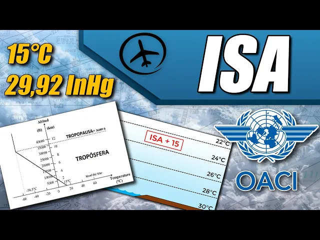
We just saw how the pressure behaves in this ISA model Let´s now continue with the air temperature The ISA model assumes that the standard temperature at sea level is 15°C And it decreases 1,98°C (aprox. 2°C) per 1000ft of altitude increase inside the troposphere We´ll discuss later what is the troposphere So according to this, at sea level in standard conditions we would measure a temperature of 15°C At 1000ft we would measure 13°C At 2000ft we would have 11°C, and so on So, as we said before, this rule only applies inside the troposphere To get into context The atmosphere is divided in several layers, each one with different characteristics and propieties The first layer we find right above the surface is called the troposphere Here, as we said before, the temperature reduces 2°C per 1000ft It is like this until reaching an altitude of 36. 089ft (Aprox.
11Km) Where we find the tropopause, which is another layer of the atmosphere This is characterized by the fact that the temperature is kept constant Therefore there´s no change in temperature with altitude anymore It is like this until reaching an altitude of 65. 617ft (Aprox. 20Km) Where we find another layer of the atmosphere called the stratosphere where the temperature increases slightly with altitude However, considering that almost all the aircrafts fly below the stratosphere We will not deal with it in detail Having in mind what we have just seen The air temperature decreases with altitude until reaching the tropopause So, we would start with 15°C at sea level At 15.
000ft we would have aprox. -15°C At 30. 000ft we would have -45°C Until reaching 36.
089ft Where we would have -56,5°C according to the ISA model And it is at this point where the tropopause begins Where the temperature is kept constant Therefore, if we measure the air temperature at 40. 000ft or 50. 000ft it would still be -56,5°C Now we have to take into account that this are the values of the ISA model Because in reality, the altitude at which we find the tropopause varies depending on our geographical location For example, near the equatorial line, the tropopause is usually very high compared with polar regions, where it is fairly low But here, as we are using an universal reference model, this are the standard values to be assumed in ISA All of this gives as a result, a graph like this As we can see, from 0ft to 36.
089ft the temperature decreases with altitude at a rate of 2°C / 1000ft. And then it remains constant at -56,5°C Now. .
. sometimes it is necessary to caclulate which is the standard temperature at a certain altitude We could do it manually, but it is way easier to use this formula ISA equals 15 minus 2 times altitude divided by 1000. As a side note, if the altitude is higher than 36.
000ft then we directly assume that the ISA temperature is -56,5°C Since as we said before, there´s where we find the tropopause So this formula only applies to lower levels Let´s see an example of how to use it Let´s suppose we are asked to find the standard temperature at 23. 000ft Well, in this case we only have to replace the altitude with 23. 000ft We do the calculations, and that gives as a result a temperature of -31°C Which would be the standard temperature at 23.
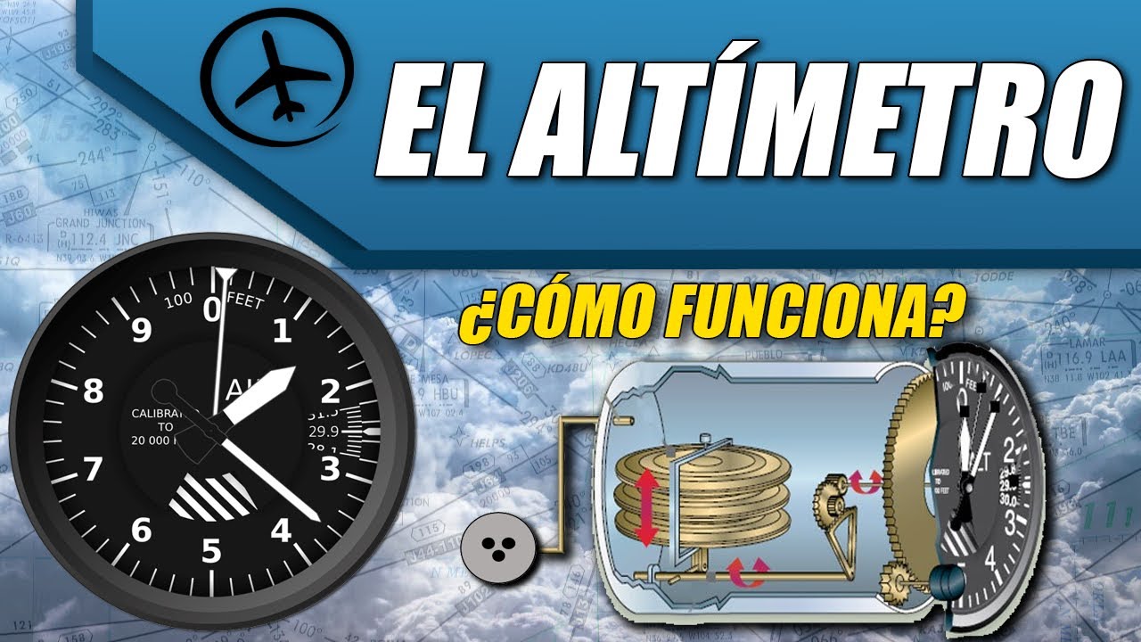
000ft according to the ISA model All this valures we are calculating here are approximate values Since the exact values are published in the ICAO Doc. 7488 ISA conditions table Here´s something we have to clarify In practice, the actual atmospheric conditions are almost never standard So we almost never find ISA conditions We could think: "If this conditions almost never exist, why is this ISA model used? " Well, actually the ISA model is used as a reference more than a set of expected or average conditions With that being said, the ISA model is used widely in aviation For example for instruments calibration Mainly the airspeed indicator and the altimeter As well as in the development of performance tables which determine how will the aircraft behave under a given set of conditions Having in mind that ISA is a reference model There´s a very important concept to understand, which is called "ISA Deviation" This is a way to express how different are the actual conditions compared to the ISA model (Standard) Normally in terms of air temperature Let´s see an example Let´s suppose there´s a person under ISA conditions Therefore, at sea level, this person measures a temperature of 15°C This only in theory Now let´s suppose that in reality, that person measures 25°C instead of 15°C Then if we compare the real conditions with the standard conditions We can see that there´s a difference, a deviation from ISA In this particular case, the real conditions are 10°C warmer that the standard Therefore we say that we have ISA+10 conditions And that would be our ISA deviation So in other words, the ISA deviation is obtained by comparing the actual conditions with the theoretical standard ones For example, under ISA conditions At 0ft we would have 15°C At 2000ft we would have 11°C At 4000ft 7°C And at 6000ft 3°C If we observe the ISA-20 model, a colder model At 0ft we would have -5°C, so it is 20°C colder than standard So that´s why it is called ISA-20 At 2000ft we would have -9°C At 4000ft we would have -13°C And at 6000ft we would have -17°C On the other hand If we observe a ISA+20 model, We would see that at 0ft, the temperature is 35°C It means, 20°C warmer than the standard At 2000ft we would have 31°C At 4000ft we would have 27°C And at 6000ft 23°C As we can see, the different conditions are always expressed in terms of ISA deviation In this particular example we talked about ISA-20 and ISA+20, but those values could have been ISA+3, ISA+8 or any other Another thing to take into account is that in a certain aerodrome or area, the ISA deviation won´t be always the same throughout the day, the ISA deviation value will be constantly changing Let´s see an example let´s suppose we have an aerodrome which is located at sea level In this case the standard ISA temperature is 15°C So, according to the ISA model, the air temperature at the airport should remain constant at 15°C And that simply doesn´t happen in real life For example if we measure the temperature early in the morning it will have a low value In this example, 8°C Then if we compare the actual conditions with the standard (ISA) we will see that the deviation is ISA-7 Since the real conditions are 7°C colder than standard Now, this is only true at 6:00am Because as the day progresses, the temperature will increase In this case to 18°C If we now compare the actual conditions vs the standard, we will see that the deviation is now ISA+3 Because the real conditions are 3°C warmer than standard This example in particular was very simple, because we already know that the standard temperature at sea level is 15°C But now let´s see another example with an airport with a higher elevation In this case this airport has an elevation of 4000ft In order to determine the ISA deviation, first we have to calculate the standard temperature at 4000ft So for this we can use the formula Which give us as a result a standard temperature of 7°C at 4000ft Now let´s suppose that at 6:00am the temperature is 11°C In this case, the actual conditions are ISA+4 And as the day progresses, the temperature will increase And at 1:00pm, the temperature reaches 21°C So in this case the ISA deviation is now ISA+14 And this concept doesn´t only apply to aerodromes but also to any other altitude For example, let´s suppose that this aircraft is flying at 6500ft And the instruments onboard measure a temperature of 8°C So, what is the ISA deviation in this case?
Well, first of all we need to calculate the standard temperature at 6500ft So applying the formula, the result is 2°C So if we compare the actual conditions with the standard, we can see that we are operating under ISA+6 Which can be really useful for the cruise performance calculations Since as we said before, this ISA deviation has several applications in aviation Specially in performance calculation For example, here we have a cruise performance table And this takes into account different conditions But we can see that they are expressed in terms of ISA deviation In the center column, we have ISA (standard) conditions In the left column, we can observe ISA-20 conditions And in the right one we can see ISA+20 Therefore, before using the table, the pilot needs to find out the ISA deviation in order to use the proper column And we have to say that the temperature plays a very important role when it comes to performance as we have seen in previous videos Sometimes, it isn´t even necessary to calculate the ISA deviation manually Since some avionics systems does this automatically in real time, as we can see here With this, we finish everything that concerns the ISA atmosphere Let´s have a little summary ISA is an international standard model of air pressure and temperature at different altitudes In terms of temperature, it is assumed that at sea level it is 15°C And it decreases at a rate of 2°C per 1000ft Until reaching 36.