thank you very much for joining me I'm meteorologist Brian Shields and thank you for being part of this weather Community All Eyes Of course on Milton this is going to become a powerful hurricane as really all hurricanes are in one way or another I want to show you what could happen over toward the yucatana Mexico kind of what's going on First and watching Western Cuba where most of the heaviest weather should stay to the north so I want to get into what we could expect near Merida over toward Cancun and then start to look down
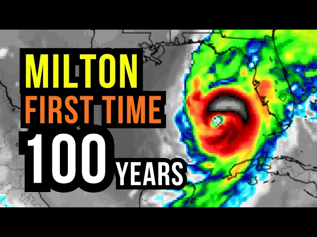
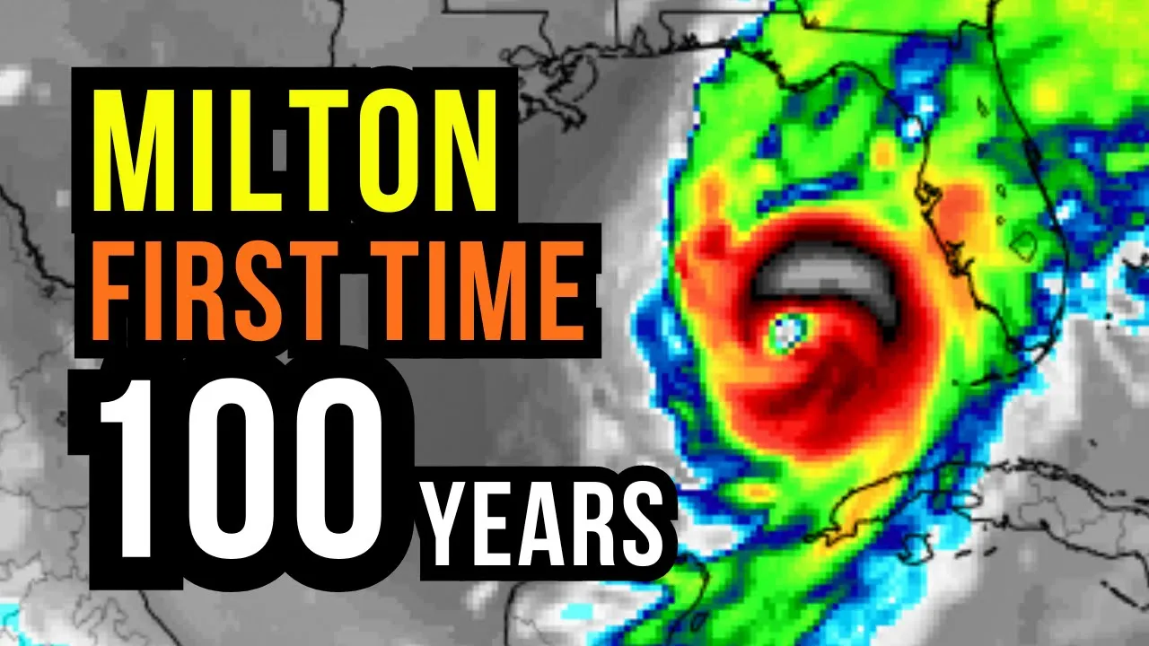
the road now this could be the first Direct Hit right into the Tampa area in over 100 years a very high concern but the landfall eventually down the road could be anywhere from near Tampa All the Way South through Fort Meyers uh that still needs to be fine-tuned so with that uh do this channel for safety so if you're in the Tampa St Petersburg area all the way down through say Fort Meyers if you have any uh alerts to evacuate or if the local officials ask you to evacuate please please do so then as we
work Inland I am concerned with some flooding and high winds of course through Central Florida if you're watching in Central Florida right now wftv.com a great resource for live streaming for preparations and county by county exactly what you could expect again wftv.com they'll be live streaming through the entire uh system as it works in to give you the very specifics on what you could expect uh where you are and then down the road I'm a little more optimistic for the Bahamas and watching Bermudas so I want to expand things out still a big concern for
us in the northern Bahamas a mod monitoring free Port over toward uh New Providence for some eventual or the at least the potential of some tropical storm impact so I'm going to take you out in time uh nice and slowly here I do apologize this video is going to be a little bit long but now for today uh it is a tropical storm and it ramped up quickly yesterday but this forecast that I showed you yesterday is generally on track and that's my goal not to have any big changes with the forecast to give you
a heads up so you can uh prepare made some minor tweaks in this but really nothing big from yesterday which is which is good winds at 75 mph tomorrow so it will be a hurricane tomorrow will be hurricane Milton then it is going to strengthen more so on Tuesday then on Wednesday that eventual landfall now uh it's also not only do I not know exactly where it's going to come on Shore yet which makes sense uh because it's still kind of getting its act together uh but also the timing is a little bit different the
timing this time of year is trickier because they fronts to the north so sometimes it could bring it in a little bit quicker sometimes things can slow up we'll cover that but winds could be near 100 milph or up to about 115 with a landfall as of now near the St Petersburg area working right across central Florida so again uh please stay tuned to uh WFTV because with hurricane Ian for example there were so many different spots uh that got flooding in Central Florida there were a lot of flood emergencies so I want you to
have the very latest information on that and then this swings off the Space Coast on on Thursday and it's going to transition into almost a subtropical system it's going to get tied up into a front on this heading this would keep the worst weather North of the northern Bahamas just to the north of the Yucatan and significantly north of Cuba in Flor the Florida Keys heaviest weather would be to the north but if this were to work into say the fort Meers area of course that would shift everything uh to the South here's the National
Hurricane Center in which they did Issue tropical storm warnings which makes good sense for the extreme Northern portions of the Yucatan of Mexico the hurricane conditions uh are going to stay to the north so if you're in Merida if you're in Cancun the hurricane conditions will be to the north over the open Waters of the Gulf of Mexico and then substantially to the north of Western Cuba which is very good news of course for Western Cuba and again all of this stays away uh for Jamaica the Cayman Islands this stays away back through Puerto Rico
all of this is going to be running right up here so let me go model by model for you the American model same thing brings this in uh near the Tampa area with a landfall in the afternoon on Wednesday so a lot of the action is going to be through the day on Wednesday uh winds around 150 miles per hour at landfall and then it becomes a tropical storm offshore as it transitions kind of gets tied up into a front and becomes a little more subtropical now the European model is very close to the same
winds at landfall Point later in the day on Wednesday would be near 100 milph uh very close to Tampa South maybe anamarie Island clear water could be even a touch South there watching over toward uh Bradenton as this moves on Shore and then working across once again so that's a Europe model very similar to the American model now the Canadian model is different it's more south and slower this would have a landfall late in the day Thursday and that's why I do mention some of the discrepancies so it's kind of a wait and see on
a few things just fine tuning a few things overall you're making the preps for tropical storm and hurricane conditions throughout much of the peninsula of Florida 90 mph winds on the Canadian model at landfall and this would be a landfall a little bit closer to the Fort Meers area the potential of that and then swinging back here the uh icon model shows a hurricane uh Wednesday morning this one's a little earlier now I'm leaning to both the American and European model so I don't like to just show you everything and leave you hanging on kind
of what I'm thinking uh that's what I I'm thinking I do think this comes in very close to the St Petersburg area winds roughly around 100 mph or more and we'll dive into the intensity in just a moment but I do want to show you kind of everything that is out there so you have all the information uh you you need now the computer models have been very consistent with this all these squiggly lines just like a computer or device you may have uh at home or at work uh they're they're different some are higher
powered some are better in different situations so that's why kind of behind the scenes I try to take all these squiggly lines kind of narrow it down for you now out in time it does show strengthening now this time of year I mentioned the timing is a little tricky with with the fronts because you get those fall fronts moving in so is the intensity uh because if the fronts uh could the fronts could kind of play a factor in this I'll just leave it at that but this is a a day out this is two
days out so two days out let's go up in time these computer models most of them have this in the category 2 range here that orange shading there some stronger some a little weaker and the models range from anywhere from a category one to a category 5 let's go somewhere in between at this uh Point as as far as intensity goes so roughly around Category 2 maybe a category 3 at landfall time now here's the American model and then I'll show you the European model and I want to show you the Windfield too so here's
Mexico first thing is first watching over toward Merida heaviest weather stays to the north that is a very very good news we need these things to stay over water I do not like storms that's actually why I do weather uh I want these things to stay away from folks a surge of moisture at ahead of it that's bad news like what happened with Helen up uh here up into the Carolina they had rain before the system even moved in that's going to be the same thing for Florida there's rain before this even moves in and
that's why I mentioned those resources at the beginning with a probability high probability of flooding right across parts of uh Florida but there's the core of it so this is tomorrow afternoon uh becoming a hurricane it will be a hurricane hurricane conditions the core stays north of Mexico but once again there's that surge of moisture out ahead of it which is just awful because you could get a few inches of rain before this even works in and then going out in time here this is by Tuesday afternoon all the preps in Florida should be done
uh by later in the day on Tuesday you want to get everything done over the next few days here's Mexico here's Cuba and you see Cuba this is going to stay well to the north if you have friends family in Cuba you're letting them know about this again the heaviest weather all stays to the north of Cuba watching the keys for the Florida Keys just depends on if it's going to be that Southern Track or a little bit more of that Northern Trek but here the americ model has this becoming a very strong hurricane as
really all hurricanes are that's why they're called hurricanes Brian uh but nonetheless this would make landfall uh sometime either uh dur or sometime during the day on Wednesday the timing again can change by four or five hours could come in a little bit in the morning or maybe more so in the afternoon this brings it on Shore right up through Tampa Bay which would be the first time in over 100 Years of a direct hit in the Tampa area now where it comes on Shore and South that's where there'll be a huge push of water
to the north the water's actually going to be coming out so it's going to be very critical where this makes landfall keeping an eye on the Northern Bahamas got you covered in the Bahamas if anything gets uh different with this I'm going to zoom down Island by Island for you and then this works across so by the time we get into Thursday the americ model already has a spin-off Shore you kind of look at the map and it almost doesn't look like uh anything crazy at this point it's going to be a broad spin I'll
show you that with the winds here in a second uh it's going to transition into a subtropical so not truly tropical system uh down the road once it gets tied up into the front let me show you that to you here here are the the winds and to keep everyone covered kilm an hour and miles per hour on the map uh so here's Mexico and you see it winding up in the Reds and some of the yellows starting to pop up as it gets stronger this here is by tomorrow will be a hurricane at that
point winds are going to be right around 75 to 80 miles hour so we're looking at some very strong winds just off the coast of Mexico but clipping by the ucatan with some tropical storm conditions could have some gust around 50 miles per hour 80 kilometers an hour uh but nothing uh the folks uh here can't handle and then north of Cuba this here is by the time we get into Wednesday stopping it here you see Wednesday morning right here that's where it could become a major hurricane even if it's not it's going to be
a powerful hurricane obviously as this moves in uh winds you can see some of the yellow showing up there 90 or higher uh could be 110 to about 115 with that landfall as we work our way right into uh Wednesday late morning uh into the afternoon working across and then it works AC cross with strong tropical storm and hurricane winds right across parts of uh Central Florida potentially even North Florida and then it starts to work offshore by Thursday morning and you see it there in kind of a broader spin once it moves offshore the
winds are actually the wind field is actually going to expand it's a really compact system now but once it moves offshore of Florida near the Bahamas the Windfield expands which means Northern Bahamas what I'm seeing now uh Freeport New Providence uh we're looking at some tropical storm uh wind wind as we work our way in through the day on Thursday I'm not seeing this as a Dorian situation which is always in the back really in the front of our minds right not see I'm not seeing that this will start to just be a big Wind
Maker offshore with those higher Seas on Thursday and then move away now if the Canadian model is on to something all of this timing would be a little bit slower but overall the impacts and kind of what I'm seeing overall uh generally stays the same here's the European model so you get over to the coast of Mexico here here's Cuba Florida here watching the Bahamas here keeping an eye on Bermuda Bermuda I'm not seeing this as a threat long term there's that surge of moisture out ahead of it now our FR obviously the West Coast
of Florida was so impacted uh by Helen there's piles of debris just devastating on the west coast so again this is going to be backto back systems moving in but our friends Georgia to the north through the Carolinas which are also uh devastated by Helen this stays to the South but hitting some of the exact same areas that got so much flood uh with Helen in the west coast of Florida so here it is becoming that hurricane tomorrow this is the European model look how in line it is with the American model so that would
keep the heaviest weather to the north of amida here and then here's Cuba and then working its way over here uh this would be a strong hurricane category 1 category two by the time we get into Tuesday heaviest weather just to the north stays to the north of Cuba here the Florida keys right in here right you got Jamaica here Cayman Islands here Northern Bahamas and right through Florida here and then this is going to work its way from Tuesday into Wednesday uh strengthening some before it makes landfall into the Tampa area uh but this
is not just a Tampa scenario obviously look how big look how big it is impacting the entire peninsula of Florida the entire Peninsula will either have tropical storm or hurricane conditions there's kind of no escaping that right uh the angle it's taking is a little bit different it's coming right in uh it's not making a little curve so even some wobbles aren't going to make a big difference overall they'll make a big difference with the The Surge which will break down further over the next couple days and then the European model has it offshore north
of the Bahamas the center on Thursday but I mentioned that Windfield is really going to expand there'll be Gusty winds on uh Thursday all the way from the Outer Banks of uh North Carolina down through the Bahamas just because it's going to be a broad Windfield and then you see it here most of the models just kind of have uh something fizzling getting caught up into a front here we are in Bermuda right in here so not seeing this long term as a threat for Bermuda trying to think of everyone uh down the road now
the wind shear so so very tricky I was really hoping that this would play more of a factor still May because there's still uncertainty with this this time of year windsh those winds up above that could just kind of rip apart these systems which we like most of the wind share will be up here but eventually as this moves into Florida it will get tied into that wind shear and that front that's why we'll see it go from a hurricane back into more of a subtropical system once it moves offshore so Ju Just watching this
I wish the windsh was a little bit more south at this point which it's not water temperatures of course very warm they did go down some when Helen uh moved over the Eastern Gulf of Mexico but they have rebounded slightly looking at about 86 degrees Fahrenheit could be a little bit warmer in a few spots here 30° celsi so water temperatures are warm uh but one thing is this is a small system right initially initially it's going to it's going to expand but if that uh pocket of a kind of if the core of this
rolls over that I know this map's a little bit hard to see but it's a wonderful uh product uh that's put out see that red right there if the core of this were to run right over that that's not only warm water but it's warm deep water so as it CHS up the water it just CHS up more water this is heat content uh there are these Hot Pockets in the in the water we saw that with barrel uh we saw that with Helen as Helen developed in the Western Caribbean uh but if it rolls
over that that could really intensify it so it's going to be a close call as far as the intensity goes and as of now uh we're looking at anywhere from a category 2 to Category 3 so winds could be near 100 or plus uh as this makes landfall but it's going to be that surge too where it comes on Shore the center of it uh the center and just to the South there's going to be a big push of water that's why I mentioned please listen to the local officials don't mess around with this one
because the angle it's taking if they ask you to leave leave period and think of yourself I know it's hard to say but almost grateful if you do have the means to leave because a lot of folks do not have the uh means to uh to leave and uh make other accommodations so we're thinking of you though dealing with this back to back no doubt uh with this over toward the west coast of Florida but there are the higher seas and all of this uh will be working in as far as the surge goes it's
going to be upwards of 12 maybe plus feet but as far as where that's going to be still to be determined just because does it move into uh the Tampa area is a little bit more to the south over toward Fort Meers but as we work our way into Friday of course the Atlantic waters are going to stay extremely uh dangerous with the elevated Seas so we are rolling down the list of names and actually over the last few weeks it's been one of the most active periods in the hurricane season for the last few
weeks on record for late September early October this is about as active as it's been from Helen Isaac was out there in the North Atlantic Joyce was out there in the Atlantic so is Kirk and Lesley which I want to show you and uh Milton now so this has been about as active as it's uh been on record for late September and early October there you can see one hurricane here one hurricane here this is Kirk huge Wind Maker Kirk will be for uh the United Kingdom over toward France they are going to have true
tropical storm conditions moving in uh there is uh Leslie and then over here of course that is Milton so let me just show you what's going on here's Bermuda uh here we are in Trinidad and Tobago now by the way Trinidad and Tobago uh we're going to have some extra rain moving in and we had some thunderstorms yesterday Guyana over towards suram not organized but we're going to see some extra rain I'll Zoom down in a moment but to show you Leslie is going to miss us in the Caribbean here's some of the extra rain
possible with that front near Bermuda but not seeing this staying as a hurricane working its way over toward Bermuda there on Wednesday that's what's left of Kirk the tropical storm conditions moving into France and over toward up toward London and then you see as we work here's Leslie uh as we work our way into Friday and it will eventually get caught up in the same front that is going to take Milton it's also going to take Leslie and just kind of keep it uh out to seea uh at this point so this is to give
you kind of that long term as we get about a week ahead you could see here the tropical storm conditions that will move especially toward the southern UK over toward France once we work our way into Wednesday it's amazing how the weather is so tied together globally here we are in tigga in Barbuda in Leslie here's Bermuda uh Leslie will stay away will eventually make that curve and then start to a weekend so this is Milton right here there's that rain I was talking about Barbados South better chance of some rain but especially over toward
Trinidad and Tobago and Guyana not an organized system but there is going to be that flood potential so giving the heads up P of Spain uh even Northeastern Venezuela we're going to see some extra rain around over the next couple days and the Dominican Republic to back toward Puerto Rico little energy around that could give us some of those scattered storms here we are in Mexico B B all of Milton stays well well to the north same thing Honduras I mentioned the Cayman Islands Jamaica this is on Monday there's some of that rain that could
clip Us by Barbados St Lucia down through Grenada and you see it here still some scattered showers so unsettled across the Southeastern Caribbean and that would lead to some pockets of flooding this here is as we work our way into a Tuesday as far as the rain goes obviously wherever Milton goes that could be over a foot of rain in some spots or up to a foot of rain that's a possibility especially with the rain that's out ahead of it I was mentioning that the batches of rain uh uh at ahead of Milton heaviest rain
north of Cuba but we may see some spots across the extreme Northern sections of the Yucatan getting about 4 in of rain or 100 millim of rain but we're looking at scattered showers elsewhere but I mentioned the Dr where we could get a few spots over the next couple days 3 to four inches of rain or over 100 millimeters of rain could see some scattered showers Puerto Rico uh down through guadaloop and Dominica Dominica to the South that's where it's more unsettled and you see look at this white and even black shading so the heads
up thank you for spreading the word Trinidad and Tobago I know all eyes are on other things which is um which makes sense uh with that said I I am watching us because we're going to see a better chance of some flooding as we go through the week ahead with not a name system just tropical moisture that will be moving in even Guyana where we had thunderstorms had a little rain yesterday too in a suram still some pockets of higher totals in Central America but I mentioned Mexico obviously most of that staying to the north
uh with Milton and way too dry uh north of Mexico City uh back through Texas so uh some scattered storms possible in Jamaica no wash out but could see a few Hit or Miss showers and storms over the next few days about a 50% chance 30% chance today in the Cayman Islands a 20% chance tomorrow and then you see that rain chance going up in Trinidad and Tobago where we're going to see the risk of some flooding as we get into the upcoming week rain chance stays kind of active tomorrow and Tuesday Barbados a 50%
chance you see that 60% chance tomorrow in St Lucia so every now and then we could get the pockets of rain and even some thunderstorms Grenada included at St Vincent the Grenadines you see by the time we get into Tuesday the rain chance bumps up to a good 60% chance of some rain a 40 to 50% chance in Martinique and about a 30 to 40% chance in Dominica over the next three days rain chance holds at 30% the next couple days in guadaloop 30 to 40% chance Antiga and Barbuda rain chance pretty small today St
kits and neas monzerat may catch a shower too as we get into the upcoming week 30 to 40% chance Anguilla and St Barts 30 to 40% % chance St Martin Sab and Stasia and we'll look at some scattered thunderstorms back through Puerto Rico a 50% chance mainly in the afternoon and evening could see a couple showers us and British Virgin Islands rain chance though in the Bahamas all lies of course on Milton if it takes that Southern Track if it goes into South Florida uh that would mean some higher uh impacts for us in the
northern Bahamas thank you for spreading the word across the Bahamas watching out for the possibility in our our northern islands of some tropical storm conditions once we work our way uh into about Thursday isolated shower storm Turks and Kos uh 30% chance Dominican Republic but a little bit higher near Santo Domingo and that's where we could get some of those downpours and a higher chance of rain we are hot across Haiti with a passing shower 20% chance in Biz very hot all of Milton staying up to the north Aruba could see a passing shower Aruba
over toward carasel rain chance 20 to 30% Bonair included and then the rain chance in Guyana a little elevated today about a 50% chance we'll see some storminess around that time cam to kind of Hit or Miss showers Cuba worst weather with Milton stays to the north uh well to the north but still that chance of some scattered showers and storms the next few days Costa Rica Panama we're looking at about a 60% chance 40 to 50% chance in Nicaragua and a 30 to 40% chance as we work our way into Honduras over the next
few days Guatemala and El Salvador about a 40% chance picks up to a 60% chance on Tuesday could get some scattered showers across Mexico City to the north it will be dry and of course course watching the Yucatan heaviest weather just misses to the north but still getting clipped by some tropical storm conditions Northern Columbia 40 to 50% chance 40% chance the next few days in Northern Venezuela and keeping an eye on Bermuda as of now the next few days that rain chance stays on the low side so major hurricane impacts uh as this system
rolls through the gulf and makes its way toward Florida in which it could be the first Direct Hit into Tampa I think it was 1921 so over a 100 years watching Mexico and Cuba in the short term in which I covered that powerful hurricane will eventually make landfall in Florida most likely Wednesday we we'll see if it gets delayed a little bit Kirk in Leslie out there watching the tropical rain in the Southeastern Caribbean this is a Super Active October I hope it calms down very soon but uh uh just so much to track over
the last few days so I'll do my best as we go throughout the day uh to get to the comments uh but I mentioned if you go back at the beginning of the video to some of the resources that maybe you could use uh as we go through uh Milton uh but I'll I'll go through those comments as we go throughout the day wherever you are be safe you're if you're making those hurricane prep uh preparations we are thinking of you and have a good rest of your day