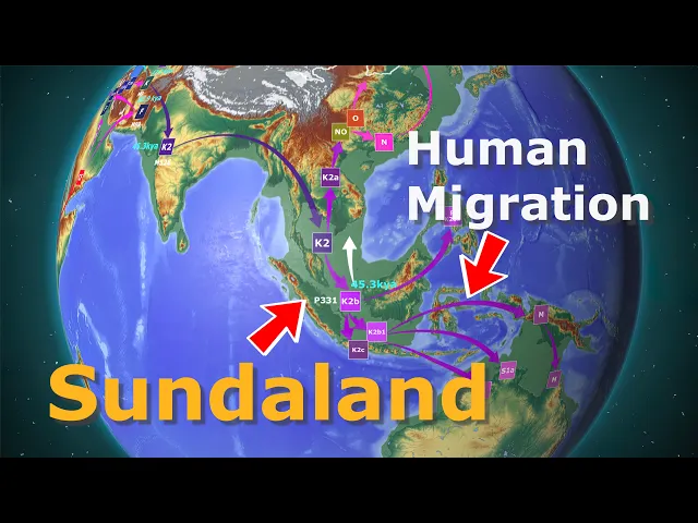
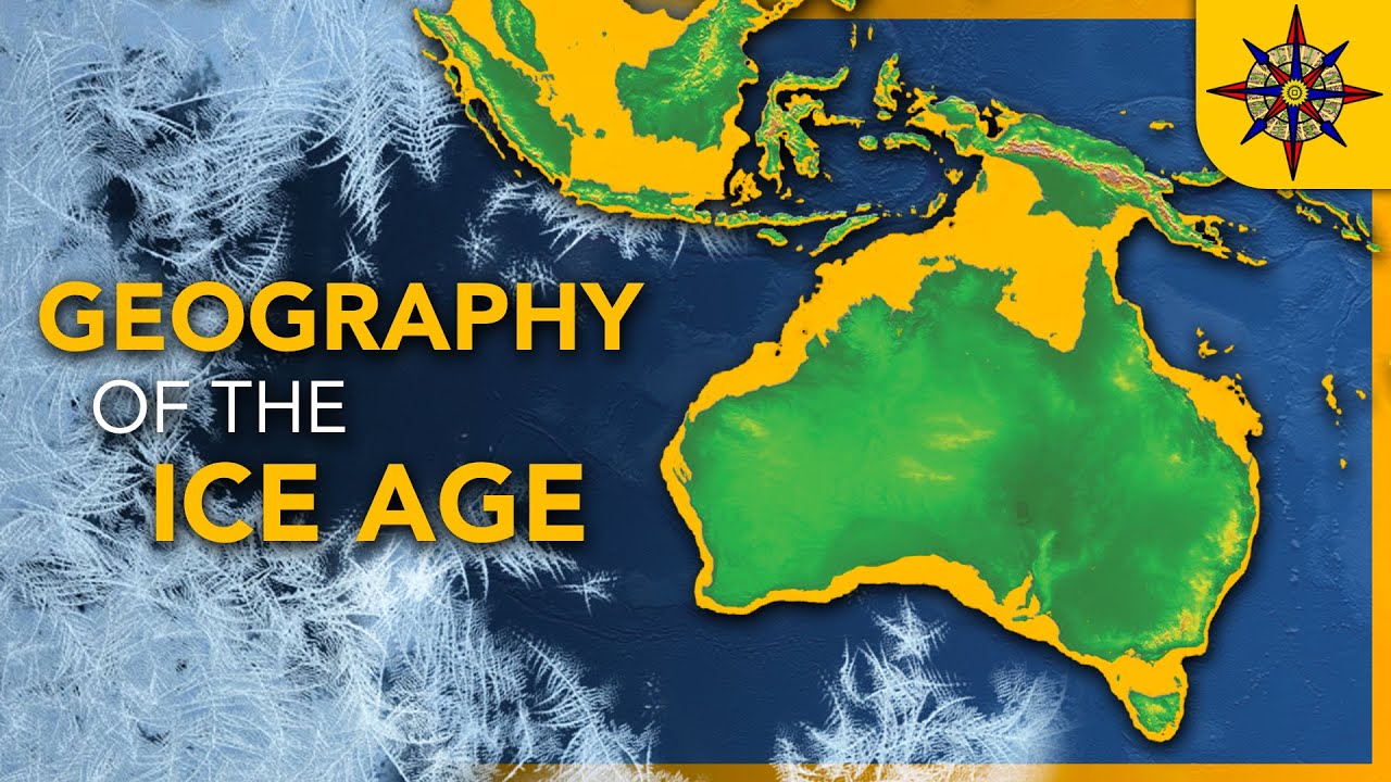
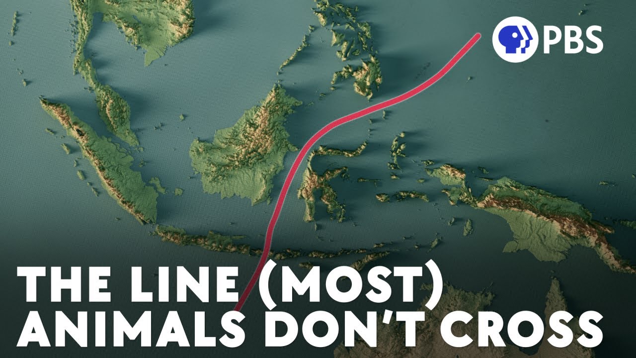
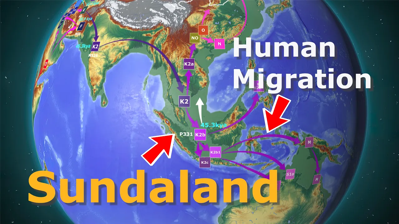
this episode introduces the geography of Sunderland in Southeast Asia linked to landbridge during the Ice Age and the early human migration associated with [Music] it when the last ice age reached its maximum there were substantial ice sheets in Europe and North America as much as 48 million cubic kilm of water was in ice so the sea level was 120 M 394 ft lower than it is now this resulted in the formation of land bridges in several places doer land in Europe and now beringia in the bearing straight the Ice Age geography of these two regions was introduced in the previous video even in Asia during this time there were areas where land bridges connected Islands this is sundaland which was in Southeast Asia in this video I will introduce the geography of Ice Age Sunderland and the migration of modern humans to Asia during the lgm the last glacial maximum Sumatra Jaba and calaman or Borneo in Indonesia were connected by a land bridge the Malay Peninsula and the Indochina Peninsula which includes Vietnam La Cambodia and Thailand are also joined by land the Philippine islands of Palawan were landlocked with Borneo only about 25 km 14. 5 M across mindo Philippines the the islands of the Philippines were also mostly landlocked the distance between Palawan and Muro connected to Borneo was only 55 km 33. 5 Mi let's move a little North hyan Island in southern China and Taiwan were also connected by land also the Yellow Sea between China's east coast and the Korean peninsula's West Coast became land the distance between Korea and Japan was less than 55 km 34 MI the East sea between Korea and Japan was left as a vast Sea Lake with only a narrow passage to the South would you like us to go south of Sunderland a Paleo continent called sahul included today Australia Tasmania New Guinea and the Yu Islands the area where Sunderland was 20,000 years before the present exactly matches where the oan countries are today oan comprises 10 countries Indonesia Malaysia the Philippines and Vietnam and others this is a geopolitically important place the Lost Sunderland was a palean Network Center associated with human migration even today the sea where sundaland was located plays a vital role in world trade the volume of work that passes through this sea reaches $3.
5 trillion 30% of World Trade goes through the sea where sundaland used to be 2/3 of China's Maritime trade passes through this sea and 40% of trade both of Korea and Japan passes through the sea where sundland used to be about 15 million barrels of crude oil pass through a daily about the same amount that passes through the straight of hormas in a day the straight of malaka is a trade choke point of East Asian countries such as China Japan Korea and Taiwan even during the Ice Age 20,000 years ago this place was an important place where many people came and went as it is now now I will briefly introduce the ecological environment of this place Asian tigers and proasus monkeys inhabit the western part of Bali the orangutan is a mammal only on the islands west of Bali from lambach island east of Bali a completely different ecosystem exists due to the year-round humid climate lambach island is blessed with giant tree forests the terrestrial fauna here is strikingly diverse from balies Treetops once occupied by primates in Bali are inhabited by birds endemic to Australia in lambach curiously the Eastern islands of Bali have more Australian parrots than Indonesian species that's not all that's surprising ceries which have been passed down from the age of the dinosaurs also live there it is a bird that has been isolated for a long time and cannot fly because its wings have degenerated this bird is also endemic to Australia Australia's representative species the kangaroo can't be found west of The Wallace Line but in abundance in the east in 1895 the famous British natural scientist Alfred Russell Wallace discovered this and Drw the distribution line that is The Wallace Line which separates the biodistribution of Southeast Asia and Australia it was confirmed that terrestrial animals endemic to Southeast Asia were distributed west of Wallace's line and Australian species were distributed East the Indonesian Islands east of Wallace's line are home to species not found elsewhere in Asia one of the giant reptiles on Earth the kodo dragon sui's smallest monkey is the Taria a species not found west of Wallace's line why do different ecosystems exist east and west of The Wallace Line at the end of the mayene the Indian and Asian continents collided slightly resulting in topographical changes at this time some of Australia's terrestrial animals migrated to Indonesia forming the unique terrestrial ecosystem of The Wallace Line a scholar named Huxley even modified this line by extending it to the Philippines since then Max Wilhelm Carl Weber has proposed Weber's line to classify Australian mammal fauna as an alternative to Wallace's line Weber's line offers the tanbar island group rather than Bali and lambach as the boundary separating Southeast Asian species from those endemic to Australia Weber's line is currently generally accepted there was the only mammal on Earth that crossed Wallace's line and Weber's line it was us humans when did modern humans cross Wallace's line into Australia the earliest date of human occupation of Australia is given from sites in the Northern Territory the ruins of the m b brck shelter in Aram land are estimated to be about 50,000 years old in a paper published in nature in 2017 the claim that it dates back to 65,000 years was refused Ed by Alan and oconnell in 2020 molecular clock estimates genetic studies and archaeological data all placed the first colonization of sahul and Australia by modern humans at 48,000 to 50,000 years ago the area where they stayed before moving to Australia was sundaland Homo erectus has been living here for at least 1. 5 million years the first colonization of Sunderland by modern humans dates back 70,000 years ago other species incl clud the denisovans and little by little interbreeding with modern humans took place melanesians and Aboriginal Australians have 3 to 5% of denisovan DNA this suggests that modern humans who interbred with the East Eurasian denisovans migrated to Australia and Papua New Guinea for the Denis OFA migration route information see the link Denny with a neanderthal mother and a daobin father the last glacial Peak was 20,000 years ago it is is also 120 M 394 ft lower at sea level the lgm began around 33,000 years before the present between 45,000 and 30,000 years ago glaciers in the northern hemisphere did not develop much 45,000 years ago Europe was almost ice free and the laurente ice sheet in North America was only 1/3 of the lgm if so the migration time of humanity does not coincide with the time when land Bridge was in Sunderland which we generally know so did modern humans who migrated to Australia not use landbridge there was another time when the Northern Hemisphere ice sheets grew to a similar extent to the lgm between 58,000 and 72,000 years ago it almost coincides with the tobo lake eruption for information on the quader glaciation see the linked Ice Age quinary glaciation and habitats of honin the time when modern humans migrated to Australia and sahul would have had a coastline similar to the lgm from now I will introduce the sundaland vegetation of the lgm period 58,000 to 72,000 years or 20,000 years ago scientists claim that traits for modern dipterocarp trees in the Southeast Asian tropical rainforest have existed since the lgm some scientists suggest that a savannah Corridor existed on the land bridge vegetation models using climate simulation data suggest that the Savannah Corridor ran down the Malay Peninsula through somatra and Java to [Music] Borneo in addition tropical rainforests and Monson or dry forests existed around the Savana Corridor before sundaland emerged during the late Pine and early Pine 2.